Harter Fell (Mardale)

Last updated

Harter Fell
Harter Fell and Blea Water from High Street.jpg
Harter Fell seen from High Street with Blea Water in the foreground
Highest point
Elevation 778 m (2,552 ft)
Prominence 149 m (489 ft)
Parent peak High Street
Listing Hewitt, Wainwright, Nuttall
Coordinates 54°28′34″N2°50′06″W / 54.476°N 2.835°W / 54.476; -2.835 Coordinates: 54°28′34″N2°50′06″W / 54.476°N 2.835°W / 54.476; -2.835
Geography
Lake District National Park UK relief location map.png
Red triangle with thick white border.svg
Harter Fell
Location in Lake District, UK
Location Cumbria, England
Parent range Lake District, Far Eastern Fells
OS grid NY459093
Topo map OS Explorer OL5, Explorer OL7

Harter Fell is a fell in the far eastern part of the English Lake District. The summit at lies the meeting point of three ridges, and Harter Fell forms the head of three valleys: Mardale, Longsleddale and the valley of the River Kent.

Contents

Topography

In plan section the summit area forms a horseshoe, open to the south east. This ridge is narrow and grassy, with a relatively new fence in place. There are subsidiary tops on both horns of the horseshoe. The southern ridge passes over The Knowe and then Brown Howe, before connecting to Kentmere Pike. The eastern branch includes the rocky top of Little Harter Fell (2,234 ft), and Adam Seat (2,185 ft) which is marked by a prominent boundary stone. This ridge continues down to Gatescarth Pass before rising again to Branstree.

Connecting to the centre of the summit horseshoe, producing a shape not unlike a tuning fork in plan, is Harter Fell's third ridge. This starts lower down the fell-side and cannot be seen from the summit. This ridge is all together rockier in character and leads swiftly down to Nan Bield Pass for onward connections to Mardale Ill Bell and High Street.

The western slopes of the fell above Kentmere Reservoir are moderately steep, with an area of historic landslip surrounding Dry Gill. A low subsidiary ridge juts out into Kentmere, separating it from the valley of Ullstone Gill. This is named for The Ullstone, a prominent erratic boulder.

The summit horseshoe of Harter Fell forms the head of Wren Gill, the main headwater of the River Sprint in Longsleddale. At Wrengill Quarry near the base of the slope, the Gill drops into sinkholes, reappearing from the ground a few yards lower down. The slopes on this south eastern side of the fell are gentle and generally grassy.

To the north above the head of Mardale, Harter Fell shows a different character. Extensive crags, unnamed on Ordnance Survey maps, drop 1,300 ft to the valley. Further crags fringe the descending ridge to Nan Bield. Below these is the beautiful mountain tarn of Small Water. This corrie tarn, with a depth of around 50 ft has brown trout and perch. [1]

Ascents

The walkers' passes of Nan Bield and Gatescarth provided historic trade routes from Mardale to Kentmere and Longsleddale respectively. With the submergence of Mardale Green village beneath Haweswater reservoir in the 1940s, their original purpose has died, but both routes still provide good access for fellwalkers and are the easiest ways onto Harter Fell. The upper sections still bear the original zig-zags over steep ground. The fell is most frequently climbed from Mardale, as there is road access along the shore of Haweswater. Harter Fell summit is 1 mile or 1.5 km southwest and 1,800 ft or 550 m above the carpark at the head of the reservoir. Crags block a direct ascent, however, and Harter Fell is thus normally climbed via Gatescarth Pass to the east of the summit, or Nan Bield Pass to the west. These two passes also provide the easiest access from Kentmere or Longsleddale.

A longer route from the Kent valley follows the ridge that separates it from Longsleddale, taking in Kentmere Pike on the way. This may form part of the Kentmere Horseshoe walk which also includes the Ill Bell ridge. An ascent of Harter Fell may also be combined with fells such as Branstree, Mardale Ill Bell and High Street to form a high-level circuit of Mardale from the road end. Finally, direct ascents from Longsleddale can also be made up the grassy slopes above Wrengill Quarry.[ citation needed ]

Summit

As well as a pile of stones, the summit cairn of Harter Fell carries many pieces of ironwork salvaged from the fence. Some of these resemble upended pitchforks, and when encountered unexpectedly on a misty day, the effect is faintly nightmarish. [2] A second cairn to the north carries similar decoration. The view is good all round and can be improved by moving to the rim of the crags, bringing the full length of Haweswater into sight.

Listing

Harter Fell was originally listed as a Marilyn in Alan Dawson's The Relative Hills of Britain, but it was later found not to have the required 150 m of relative height, missing out by 1 metre.[ citation needed ]

Related Research Articles

<span class="mw-page-title-main">Longsleddale</span> Valley and civil parish in Cumbria, England

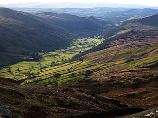
Longsleddale is a valley and civil parish in the South Lakeland district of Cumbria, England. It includes the hamlet of Sadgill. The parish has a population of 73. As the population taken at the 2011 Census was less than 100, details are maintained in the civil parish of Whitwell and Selside.

<span class="mw-page-title-main">Seatallan</span>

Seatallan is a mountain in the western part of the English Lake District. It is rounded, grassy and fairly unassuming, occupying a large amount of land. However, it is classed as a Marilyn because of the low elevation of the col connecting it to Haycock, its nearest higher neighbour to the north. The name Seatallan is believed to have a Cumbric origin, meaning "Aleyn's high pasture".

<span class="mw-page-title-main">Branstree</span> Fell in the Lake District, Cumbria, England

Branstree is a fell in the Far Eastern part of the English Lake District. It overlooks the valley of Mardale and Haweswater Reservoir.

<span class="mw-page-title-main">Yoke (Lake District)</span> Fell in the Lake District, Cumbria, England

Yoke is a fell in the Lake District in Cumbria, England. It has a height of 706 m (2,316 ft) and is situated in the far eastern sector of the national park, 6½ kilometres ENE of the town of Ambleside. Yoke is the southern extremity of the long ridge that runs southwards from the fell of High Street. Yoke’s name is believed to be derived from the Old English language word geoc which is similar to the German word joch meaning mountain ridge.

<span class="mw-page-title-main">Shipman Knotts</span>

Shipman Knotts is a fell in the English Lake District in Cumbria, England. It reaches a height of 587 metres (1,926 ft) and is situated in one of the quieter areas of the national park, 2 kilometres (1.2 mi) north-east of Kentmere village. Although not one of the best-known Lake District fells, it earned a separate chapter in Alfred Wainwright’s Pictorial Guide to the Lakeland Fells due to “Its characteristic roughness. .. rocky outcrops are everywhere on its steep slopes”.

<span class="mw-page-title-main">Red Pike (Buttermere)</span> Mountain in the English Lake District, Cumbria, England

Red Pike is a fell in the High Stile range in the western English Lake District, which separates Ennerdale from the valley of Buttermere and Crummock Water. It is 2,476 ft (755 m) high. The direct ascent of Red Pike from Buttermere is very popular and the ridge walk from Red Pike to Haystacks is regarded as one of the finest in the area, with excellent views of the Scafells, Great Gable and Pillar.

<span class="mw-page-title-main">Ullscarf</span> Fell in England

Ullscarf is a fell in the English Lake District close to the geographical centre of the Cumbrian hills. It forms part of the watershed between the Derwentwater and Thirlmere catchments, a ridge running broadly north-south.

<span class="mw-page-title-main">Wether Hill (Lake District)</span> Fell in the Lake District, Cumbria, England

Wether Hill is a fell in the English Lake District, between Martindale and Haweswater. It lies on the main north-south ridge of the Far Eastern Fells between Loadpot Hill and High Raise. Lesser ridges also radiate out to the east and north-west.

<span class="mw-page-title-main">High Raise (High Street)</span> Mountain in the English Lake District, Cumbria, England

High Raise is a fell in the English Lake District, standing to the west of Haweswater Reservoir in the Far Eastern Fells. Note that another High Raise is the highpoint of the Central Fells.

<span class="mw-page-title-main">Rampsgill Head</span> Fell in the Lake District, Cumbria, England

Rampsgill Head is a fell in the English Lake District, standing to the west of Haweswater Reservoir in the Far Eastern Fells. It forms the focal point of three ridges which fan out north-east, north-west and south.

<span class="mw-page-title-main">Kidsty Pike</span>

Kidsty Pike is a fell in the English Lake District, standing to the west of Haweswater Reservoir. It is a subsidiary top of Rampsgill Head, but has long achieved the status of a separate fell, thanks to its classic peaked profile. Wainwright followed this convention in his Pictorial Guide to the Lakeland Fells.

<span class="mw-page-title-main">Thornthwaite Crag</span> Mountain in United Kingdom

Thornthwaite Crag is a fell in the English Lake District, standing to the west of Haweswater Reservoir. It is a focal point of the Far Eastern Fells, standing at the head of several valleys.

<span class="mw-page-title-main">Mardale Ill Bell</span>

Mardale Ill Bell is a fell in the English Lake District, rising to the south west of Haweswater Reservoir. It stands on the watershed between Mardale and Kentmere and is the highpoint of the south-eastern ridge of High Street, midway on its course to Harter Fell.

<span class="mw-page-title-main">Kentmere Pike</span>

Kentmere Pike is a fell in the English Lake District, rising between the valleys of Kentmere and Longsleddale. It is the highpoint on the ridge between Harter Fell and Shipman Knotts.

Selside Pike is a fell in the English Lake District. It stands between the valleys of Mardale and Swindale in the Far Eastern Fells.

<span class="mw-page-title-main">Tarn Crag (Far Eastern Fells)</span> Fell in the Lake District, Cumbria, England

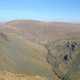
Tarn Crag is a fell in the English Lake District. It stands to the east of Longsleddale in the Far Eastern Fells.

<span class="mw-page-title-main">Grey Crag</span> Fell in the Lake District, Cumbria, England

Grey Crag is a fell in the English Lake District. It stands to the east of Longsleddale in the Far Eastern Fells.

<span class="mw-page-title-main">Nab Scar</span> Mountain in the English Lake District, Cumbria, England

Nab Scar is a fell in the English Lake District, an outlier of the Fairfield group in the Eastern Fells. It stands above Rydal Water.

<span class="mw-page-title-main">Bowscale Fell</span>

Bowscale Fell is a hill in the English Lake District. It rises above the village of Mungrisdale in the Northern Fells. Bowscale Fell stands at the extreme north east the Blencathra group, connected to this higher fell by the intervening Bannerdale Crags. In common with many fells the western slopes are smooth and convex while the eastern side exhibits crags.

<span class="mw-page-title-main">Far Eastern Fells</span> Mountain range in Cumbria, England

The Far Eastern Fells are a group of hills in the English Lake District. Reaching their highest point at High Street, they occupy a broad area to the east of Ullswater and Kirkstone Pass. Much quieter than the central areas of Lakeland they offer in general easier walking as the fells merge mainly into the surrounding moorlands.

References

  1. Blair,D: Exploring Laleland Tarns:Lakeland Manor Press (2003) ISBN   0-9543904-1-5
  2. Alfred Wainwright: A Pictorial Guide to the Lakeland Fells , Book 2: ISBN   0-7112-2455-2