
Alpine Village is a census-designated place (CDP) in Alpine County, California, United States. The population was 114 at the 2010 census, down from 136 at the 2000 census.

Bowles is a census-designated place (CDP) in Fresno County, California, United States. The population was 166 at the 2010 census, down from 182 at the 2000 census. Bowles is located 11 miles (18 km) south of downtown Fresno, at an elevation of 279 feet.
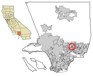
Mayflower Village is a census-designated place (CDP) in the San Gabriel Valley, in Los Angeles County, California, United States. The population was 5,515 at the 2010 census, up from 5,081 at the 2000 census. The ZIP Codes serving the community are 91006, which is served by Arcadia and 91016, which is served by Monrovia.
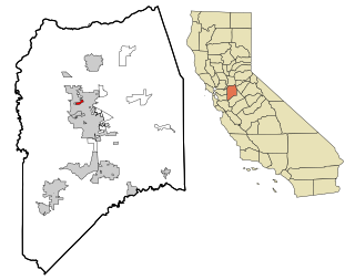
Lincoln Village is a census-designated place (CDP) in San Joaquin County, California, United States. The population was 4,381 at the 2010 census, up from 4,216 at the 2000 census.
Emden is a village in Logan County, Illinois, United States. The population was 485 at the 2010 census. The village was named after Emden, Germany due to the large number of residents who immigrated to the area from villages along the River Ems

New Holland is a village in Logan County, Illinois, United States. The population was 269 at the 2010 census, down from 318 in 2000.

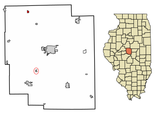
Pleasant Hill is a village in Pike County, Illinois, United States. The population was 966 at the 2010 census.

Lakeland Village is a census-designated place (CDP) in Riverside County, California, United States. The population was 11,541 at the 2010 census, more than double the 5,626 reported at the 2000 census.

Hartsburg is a village in southern Boone County, Missouri, United States. It is part of the Columbia, Missouri Metropolitan Statistical Area. The population was 133 per the 2020 census.

Westwood is a village in west St. Louis County, Missouri, United States. The population was 316 at the 2020 census.

Sodus Point is a village in Wayne County, New York, United States. The population was 900 at the 2010 census. However, the last official US Census in 2020 recorded the population at 822. The name is derived from a nearby body of water, Sodus Bay. It is considered to be within the larger Rochester metropolitan area.

Warsaw is a village in Coshocton County, Ohio, United States, along the Walhonding River. The population was 624 at the 2020 census.

Brice is a village in Franklin County, Ohio, United States, on the southeast side of the Columbus metropolitan area. The population was 93 at the 2020 census.

Metamora is a village in Fulton County, Ohio, United States. The population was 566 at the 2020 census.

Whitehouse is a village within the Toledo Metropolitan Area in Lucas County, Ohio, United States. The population was 4,990 at the 2020 census.

Jerry City is a village in Wood County, Ohio, United States. The population was 454 at the 2020 census.

Browntown is a village in Green County, Wisconsin, United States. The population was 280 at the 2010 census.

Taylor is a village in Jackson County, Wisconsin, United States, along the Trempealeau River. The population was 484 at the 2020 census.

South Wayne is a village in Lafayette County, Wisconsin, United States. The population was 489 at the 2010 census.
Belmont is a town in Lafayette County, Wisconsin, United States. The population was 767 at the 2010 census, up from 676 at the 2000 census. The village of Belmont is located in the southeastern part of the town. The unincorporated community of Leslie close to the center of the town.


