Harveysburg, Ohio | |
---|---|
Nickname: Village on the lake | |
Coordinates: 39°30′04″N84°00′23″W / 39.50111°N 84.00639°W | |
Country | United States |
State | Ohio |
County | Warren |
Founded | 1829 |
Established | 1831 |
Village | 1844 |
Government | |
• Type | Council-city manager |
• Mayor | Jonathan Funk |
Area | |
• Total | 1.02 sq mi (2.64 km2) |
• Land | 0.99 sq mi (2.57 km2) |
• Water | 0.02 sq mi (0.06 km2) |
Elevation | 912 ft (278 m) |
Population (2020) | |
• Total | 554 |
• Density | 557.34/sq mi (215.19/km2) |
Time zone | UTC-5 (Eastern (EST)) |
• Summer (DST) | UTC-4 (EDT) |
ZIP code | 45032 |
Area code | 513 |
FIPS code | 39-34384 [3] |
GNIS feature ID | 2398262 [2] |
Website | www |
Harveysburg is a village in Massie Township, Warren County, Ohio, United States. The population was 554 at the 2020 census. It is best known as the home of the Ohio Renaissance Festival.
Harveysburg was platted in 1829 by William Harvey, and named for him. [4] Ardent abolitionists, the Harvey family established the Harvey Free Negro School in 1831. [5] A post office has been in operation at Harveysburg since 1839. [6]
According to the United States Census Bureau, the village has a total area of 1.01 square miles (2.62 km2), of which 0.99 square miles (2.56 km2) is land and 0.02 square miles (0.05 km2) is water. [7]
Census | Pop. | Note | %± |
---|---|---|---|
1830 | 99 | — | |
1850 | 329 | — | |
1860 | 445 | 35.3% | |
1870 | 388 | −12.8% | |
1880 | 539 | 38.9% | |
1890 | 402 | −25.4% | |
1900 | 435 | 8.2% | |
1910 | 359 | −17.5% | |
1920 | 355 | −1.1% | |
1930 | 361 | 1.7% | |
1940 | 354 | −1.9% | |
1950 | 477 | 34.7% | |
1960 | 514 | 7.8% | |
1970 | 486 | −5.4% | |
1980 | 425 | −12.6% | |
1990 | 437 | 2.8% | |
2000 | 563 | 28.8% | |
2010 | 546 | −3.0% | |
2020 | 554 | 1.5% | |
U.S. Decennial Census [8] |
As of the census [9] of 2010, there were 546 people, 204 households, and 147 families living in the village. The population density was 551.5 inhabitants per square mile (212.9/km2). There were 237 housing units at an average density of 239.4 per square mile (92.4/km2). The racial makeup of the village was 95.1% White, 1.5% African American, 0.4% Asian, 0.2% from other races, and 2.9% from two or more races. Hispanic or Latino of any race were 0.2% of the population.
There were 204 households, of which 37.3% had children under the age of 18 living with them, 57.8% were married couples living together, 7.4% had a female householder with no husband present, 6.9% had a male householder with no wife present, and 27.9% were non-families. 20.6% of all households were made up of individuals, and 5.9% had someone living alone who was 65 years of age or older. The average household size was 2.68 and the average family size was 3.08.
The median age in the village was 37.3 years. 26.4% of residents were under the age of 18; 5.9% were between the ages of 18 and 24; 27.1% were from 25 to 44; 31.4% were from 45 to 64; and 9.3% were 65 years of age or older. The gender makeup of the village was 51.1% male and 48.9% female.
As of the census [3] of 2000, there were 563 people, 191 households, and 152 families living in the village. The population density was 857.1 inhabitants per square mile (330.9/km2). There were 208 housing units at an average density of 316.7 per square mile (122.3/km2). The racial makeup of the village was 96.45% White, 2.13% African American, 0.18% Asian, 0.18% from other races, and 1.07% from two or more races. Hispanic or Latino of any race were 1.95% of the population.
There were 191 households, out of which 45.5% had children under the age of 18 living with them, 62.8% were married couples living together, 13.1% had a female householder with no husband present, and 19.9% were non-families. 14.7% of all households were made up of individuals, and 4.7% had someone living alone who was 65 years of age or older. The average household size was 2.95 and the average family size was 3.29.
In the village, the population was spread out, with 32.3% under the age of 18, 7.8% from 18 to 24, 32.7% from 25 to 44, 19.4% from 45 to 64, and 7.8% who were 65 years of age or older. The median age was 31 years. For every 100 females there were 94.1 males. For every 100 females age 18 and over, there were 92.4 males.
The median income for a household in the village was $44,750, and the median income for a family was $49,063. Males had a median income of $31,923 versus $23,333 for females. The per capita income for the village was $16,918. About 7.7% of families and 8.6% of the population were below the poverty line, including 8.4% of those under age 18 and none of those age 65 or over.
The entire village is in the Clinton Massie Local School District. Mail is delivered through the Harveysburg post office while telephone service is supplied through the Waynesville exchanges.
Manchester is a village in Manchester Township, Adams County, Ohio, United States, along the Ohio River. The population was 1,839 at the 2020 census.
Savannah is a village in Ashland County, Ohio, United States. The population was 329 at the 2020 census.
Aberdeen is a village in Huntington Township, Brown County, Ohio, United States, along the Ohio River 50 miles (80 km) southeast of Cincinnati. The population was 1,515 at the 2020 census.
Clarksville is a village in Clinton County, Ohio, United States. The population was 534 at the 2020 census. It is served by the Clinton Massie branch of the Wilmington Public Library of Clinton County.
Warsaw is a village in Coshocton County, Ohio, United States, along the Walhonding River. The population was 624 at the 2020 census.
Yorkshire is a village in Darke County, Ohio, United States. The population was 95 at the 2020 census.
Pleasant City is a village in Guernsey County, Ohio, United States. The population was 400 at the 2020 census.
Cleves is a village in Miami Township, Hamilton County, Ohio, United States. Located along the Ohio River, it is a western suburb of Cincinnati. The population was 3,414 at the 2020 census.
Evendale is a village in Hamilton County, Ohio, United States, within the Cincinnati metropolitan area. The population was 2,669 at the 2020 census.
North Bend is a village in Miami Township, Hamilton County, Ohio, United States, along the Ohio River. It is a part of the Greater Cincinnati area. The population was 835 at the 2020 census.
Hanover is a village in Licking County, Ohio, United States. The population was 1,270 at the 2020 census. The village lies along Ohio State Route 16.
St. Louisville or Saint Louisville is a village in Licking County, Ohio, United States, along the North Fork of the Licking River. The population was 352 at the 2020 census.
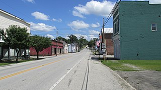
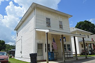
Miltonsburg is a village in Monroe County, Ohio, United States. The population was 42 at the 2020 census. Miltonsburg was named after Milton Pierson, son of Ohio pioneer David Pierson. David Pierson named Clarington, Ohio after his daughter Clarinda.
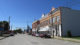
Chesterville is a village in Morrow County, Ohio, United States, along the Kokosing River. The population was 191 at the 2020 census. Chesterville is southeast of Mount Gilead, the county seat.
Edison is a village in Morrow County, Ohio, United States. The population was 422 at the 2020 census. Edison is adjacent to and west of Mount Gilead, Ohio, the county seat.
Limaville is a census-designated place (CDP) and former village in Stark County, Ohio, United States. The population was 151 at the 2020 census. It is part of the Canton–Massillon Metropolitan Statistical Area.
Hamden is a village in Vinton County, Ohio, United States. The population was 727 at the 2020 census.
Macksburg is a village in Washington County, Ohio, United States, along the West Fork of Duck Creek. The population was 120 at the 2020 census. The village is about 28 miles (45 km) south of Cambridge, Ohio.
New Holland is a village in Fayette and Pickaway counties in Ohio, United States. The population was 804 at the 2020 census.
Gratiot is a village in Licking and Muskingum counties in the U.S. state of Ohio. The population was 215 at the 2020 census.