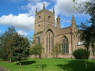
Leominster is a market town in Herefordshire, England; it is located at the confluence of the River Lugg and its tributary the River Kenwater. The town is 12 miles north of Hereford and 7 miles south of Ludlow in Shropshire. With a population of 11,700, Leominster is the largest of the five towns in the county; the others being Ross-on-Wye, Ledbury, Bromyard and Kington.

Kington is a market town, electoral ward and civil parish in Herefordshire, England. The ward had a population of 3,240, while the 2011 Census registered a population of 2,626.
Bromyard is a town and former civil parish, now in the parish of Bromyard and Winslow, in Herefordshire, England, in the valley of the River Frome. It lies near the county border with Worcestershire on the A44 between Leominster and Worcester. Bromyard has a number of traditional half-timbered buildings, including some of the pubs, and the parish church is Norman. For centuries, there was a thriving livestock market.

Moreton on Lugg is a village and civil parish in Herefordshire, England. The city and county town of Hereford is approximately 3 miles (5 km) to the south; the market and minster town of Leominster 8 miles (13 km) to the north.

Almeley is a village and civil parish in Herefordshire, England. The civil parish includes the hamlets of Almeley Wooton and Upcott. The 2011 Census recorded the parish's population as 601.
Tedstone Delamere is a village and civil parish in Herefordshire, England, 3.5 miles (6 km) north-east of Bromyard. The population of the parish at the 2011 census was 138.
Dilwyn is a village in Herefordshire, England located about 18 km (11 mi) from the city of Hereford and 9 km (6 mi) from its nearest town, Leominster. It is situated on the northern edge of a broad valley that stretches from the River Wye through to Leominster. Running through the valley, south of the village, is the Stretford Brook whilst to the north are the rivers Arrow and Lugg.

Eardisland is a village and civil parish on the River Arrow, about 5 miles (8 km) west of the market town of Leominster, Herefordshire. The civil parish includes the hamlets of Upper Hardwick, Lower Hardwick and Lower Burton.

Richard's Castle is a village, castle and two civil parishes on the border of the counties of Herefordshire and Shropshire in England. The Herefordshire part of the parish had a population of 250 at the 2011 Census, the Shropshire part, 424.
Grendon Bishop is a civil parish in the county of Herefordshire, England.
Ford and Stoke Prior is a civil parish in the county of Herefordshire, England, and is 10 miles (16 km) north from the city and county town of Hereford. The closest large town is the market town of Leominster, adjacent at the north-west. The parish includes the hamlet of Ford, the village of Stoke Prior, and the medieval parish churches of St Luke and St John of Jerusalem. At the west of the parish is the site of a Romano-British settlement.

Croft and Yarpole is a civil parish in the county of Herefordshire, England, and is 17 miles (27 km) north from the city and county town of Hereford. The closest large town is the market town of Leominster, 4.5 miles (7 km) to the south. Within the parish is the National Trust property of Croft Castle and Parkland.

Eye, Moreton and Ashton is a civil parish in the county of Herefordshire, England. The parish is 15 miles (24 km) north from the city and county town of Hereford. The closest large town is the market town of Leominster, 3 miles (5 km) to the south. Within the parish is the National Trust property of Berrington Hall, and the villages of Eye, Moreton, and Ashton.

King's Pyon is a village and civil parish in the county of Herefordshire, England, and is approximately 8 miles (13 km) north-west from the city and county town of Hereford. The closest large town is the market town of Leominster, 6 miles (10 km) to the north-west. The parish includes the Grade I listed church of St Mary the Virgin.

Pudleston, is a small village and civil parish, in the county of Herefordshire, England, and is 13 miles (20 km) north from the city and county town of Hereford. The closest large town is Leominster 4 miles (6 km) to the west. At Pudleston is the c.1200 Church of St Peter, and the 1846 Tudor-Gothic Pudleston Court.
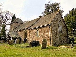
Docklow and Hampton Wafer, is a civil parish in the county of Herefordshire, England, and is 11 miles (18 km) north from the city and county town of Hereford. The closest large town is Leominster 4 miles (6 km) to the west. The parish contains the remains of Uphampton Camp, a probable Iron Age hillfort, and the Church of St Bartholomew, in part dating to the 12th and 13th century.

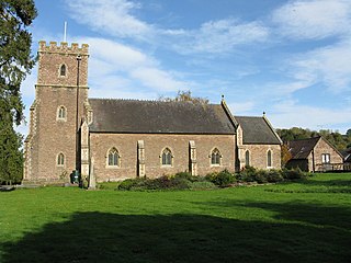
Hatfield and Newhampton is a civil parish in the county of Herefordshire, England, and is 11 miles (18 km) north from the city and county town of Hereford. The closest large town is Leominster 4 miles (6 km) to the west. The parish includes the small village of Hatfield, the former extra-parochial liberty of New Hampton, the site of former abbey lands of Fencote, the preserved Fencote railway station, and the Grade II* listed 11th-century Church of St Leonard.

Staunton on Arrow is a village and civil parish in the county of Herefordshire, England. The village is 17 miles (27 km) north-west of Hereford and 8 miles (13 km) to the west of Leominster. Within the parish is the site of the Iron Age hill fort of Wapley Hill.

Sutton is a civil parish in Herefordshire, England, about 3 miles (5 km) north-east from the county town and city of Hereford. The major settlement is the village of Sutton St Nicholas which is conjoined with Sutton St Michael, formerly the village of a separate parish. The parish is sometimes referred to as Sutton St Nicholas. Within the parish is Sutton Walls, the supposed site of the palace of the kings of Mercia.
Laysters is a civil parish in north-east Herefordshire, England, and approximately 15 miles (20 km) north-northeast from the city and county town of Hereford. The nearest towns are the market towns of Leominster 4.5 miles (7 km) to the south-west, and Tenbury Wells in Worcestershire, 3.5 miles (6 km) miles to the north-east. Within Letton is the Grade 1 listed Church of St Andrew. The parish was alternatively spelt 'Leysters', the ecclesiastic spelling.

