Hatley, Cambridgeshire

Last updated

Hatley
Churchstdenis 4216.JPG
Church of St Denis, East Hatley
Cambridgeshire UK location map.svg
Red pog.svg
Hatley
Location within Cambridgeshire
Population181 (2011)
OS grid reference TL281510
District
Shire county
Region
Country England
Sovereign state United Kingdom
Post town SANDY
Postcode district SG19
Dialling code 01767
Police Cambridgeshire
Fire Cambridgeshire
Ambulance East of England
UK Parliament
List of places
UK
England
Cambridgeshire
52°08′34″N0°07′44″W / 52.1427°N 0.1288°W / 52.1427; -0.1288 Coordinates: 52°08′34″N0°07′44″W / 52.1427°N 0.1288°W / 52.1427; -0.1288

Hatley is a civil parish in South Cambridgeshire, England. It lies between the villages of Gamlingay and Croydon, 12 miles south-west of the city of Cambridge and eight miles south-east of the town of St Neots. In 2001, the population of Hatley parish was 205 people living in 77 households, reducing at the 2011 Census to a population of 181 in 78 households. [1]

Contents

History

The Hatley name was in use as early as 986, [2] derived from 'laie' or 'ley', a woodland clearing, [3] or 'woodland clearing on the hill'. [4] The spelling Hatelaie was used in the 1086 Domesday Book. The parishes were known as 'Hungry Hatley' by 1218, possibly because the clay soil could not be cultivated effectively until mechanisation in the 20th century. [3] The adjoining parish of Cockayne Hatley, in Bedfordshire, is said to be unconnected to the Cambridgeshire Hatleys. [5]

In 1831, the population of the parish of Hatley St George was 105 people. [6] At the time of the census in 1921, it was 67 people. [7]

Governance

The parish was established in 1957 when the parish of Hatley St George was united with East Hatley. [2] Hatley Parish Council comprises five elected members (a chairman, vice-chairman and three others) and a clerk. [8] The parish is represented on the South Cambridgeshire District Council by one councillor for The Mordens ward [9] and on Cambridgeshire County Council by one councillor for the Gamlingay electoral division. [10] It is represented at the House of Commons as part of the South Cambridgeshire constituency.

Geography

Hatley is 12 miles south-west of the county town of Cambridge and 45 miles north of London. The elevation ranges between 55 and 79 metres (180–260 feet) above sea level. [11] The soil is clay subsoil with boulder clay. [7] The parish covers an area of 958 hectares. [12]

Around half of the land in Hatley parish belongs to the Hatley Park Estate. 76% of land is used for crops or fallow land; 9.5% is covered by grass, 4.9% by woodland and 7.1% by set-aside. Wheat, barley and rapeseed are grown. In summer, the estate's parkland is grazed by beef cattle and by sheep in winter. The yard at Church Farm, owned by the estate, has been converted to small business units. One other farm is in the parish and two neighbouring farmers use land in it. [13]

There are two main settlements in the parish, connected by a minor road. Hatley St George consists of a row of houses along the Gamlingay-Croydon road. It has a small shop and post office, [14] (subsidised by the estate) [13] a playing field, playground and cricket club. It is presumed that the hamlet's name is derived from that of the St George family, who were the principal landowners from the 13th century to 1658. [2] Hatley St George is an 'estate village' – Hatley Park Estate owns all the houses except for five. About a third are used for current and retired estate workers, with the others rented out. [13]

Church of St George Hatleystgeorge7567.jpg
Church of St George

East Hatley is a row of houses along a smaller road. It was formerly known as Castell Hatley. [15] In 1929, the hamlet was owned by the Master and Fellows of Downing College, Cambridge. [16] Sir George Downing, 1st Baronet, after whom Downing Street is named, owned land in East Hatley (his grandson, Sir George Downing, 3rd Baronet, founded Downing College). [3]

Historically, East Hatley housed local farm labourers. Now, few agricultural workers live there and it has been described as a 'small, middle-class commuter settlement'. The houses are mainly privately owned but there are three council-owned bungalows. There is little interaction between East Hatley and Hatley St George. [13]

Hatley village hall was built by the estate in 1960. [2] It was run as a social club before it became financially unviable, closing in 2005, and is now run by the Parish Council. [17]

Around one-third of the parish is occupied by Hatley Park, an area of private landscaped parkland south of the road, [15] formerly owned by Sir John Astor MBE. [18]

Demography

At the time of the 2001 census, the population of Hatley parish was 205 people living in 77 households. The ethnic group of 98.6% of Hatley residents was white and 1.4% Asian or Asian British. 73.7% described themselves as Christian. [12]

Hatley has a high rate of in-migration and commuting, and retains economically strong farming activities. Hatley Park once employed most Hatley St George residents. There was formerly a Thoroughbred stud farm in Hatley Park, employing 15 people, but it is now a livery yard staffed by two for most of the year. Seven Hatley St George residents were employed on the estate in 2007; a number of people work for the Royal Society for the Protection of Birds, whose headquarters is nearby at Sandy, Bedfordshire. At the time of the 2001 census, 17.7% of Hatley residents were self-employed, 2.1% were unemployed and 4% were employed in agriculture. [13]

Landmarks

Buff Wood Buffwood 4171.JPG
Buff Wood

In addition to the two churches, two buildings in Hatley parish are listed: Hatley Park Lodge [19] and model farm buildings at Church Farm, Hatley St George. [20]

Hatley St George has a church, dedicated to St George, which was first built in 1352. It is a Grade II* listed building. [21] Services take place every two weeks. [22] East Hatley's church, dedicated to St Denis, has been disused since 1980. [23] It is also a Grade II* listed building. [24] Hatley's churches are part of the ecclesiastical parish of Gamlingay with Hatley St George and East Hatley, in the diocese of Ely. [22]

There are remnants of ancient woodland: Buff Wood, south-west of East Hatley, is a Site of Special Scientific Interest (SSSI) owned by the estate and managed by the local Wildlife Trust, [25] and Hayley Wood, another SSSI, [26] borders the parish in the north. [11]

See also

Related Research Articles

<span class="mw-page-title-main">Bedfordshire</span> Historic County of England

Bedfordshire is a ceremonial county in the East of England. The county has been administered by three unitary authorities, Borough of Bedford, Central Bedfordshire and Borough of Luton, since Bedfordshire County Council was abolished in 2009.

<span class="mw-page-title-main">Pinner</span> Area of north west London

Pinner is a London suburb in the London borough of Harrow, Greater London, England, 12 miles (19 km) northwest of Charing Cross, close to the border with Hillingdon, historically in the county of Middlesex. The population was 31,130 in 2011.

<span class="mw-page-title-main">Tulse Hill</span> Human settlement in England

Tulse Hill is a district in the London Borough of Lambeth in South London that sits on Brockwell Park. It is approximately five miles from Charing Cross and is bordered by Brixton, Dulwich, Herne Hill, Streatham and West Norwood.

<span class="mw-page-title-main">Gamlingay</span> Human settlement in England

Gamlingay is a village and civil parish in the South Cambridgeshire district of Cambridgeshire, England about 14 miles (23 km) west southwest of the county town of Cambridge.

<span class="mw-page-title-main">Potton</span> English town and civil parish

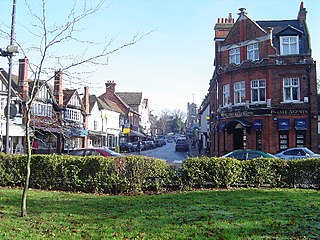
Potton is a town and civil parish in the Central Bedfordshire district of Bedfordshire, England, about 10 miles (16 km) east of the county town Bedford. Its population in 2011 was 4,870. In 1783 the Great Fire of Potton destroyed a large part of the town. The parish church dates from the 13th century, and is dedicated to St Mary. Potton's horse fairs were some of the largest in the country.

<span class="mw-page-title-main">Little Gransden</span> Human settlement in England

Little Gransden is a civil parish and village in South Cambridgeshire, England. In 2001 the population was 262 people, including Waresley and increasing to 296 at the 2011 Census. It is 11 miles (18 km) from Cambridge, on the border with the district of Huntingdonshire. Little Gransden has two airfields, one of which was used in World War II.

<span class="mw-page-title-main">Everton, Bedfordshire</span> Human settlement in England

Everton is a small rural village of about 200 dwellings and civil parish in the Central Bedfordshire district of Bedfordshire, England about 9 miles (14 km) east of the county town of Bedford.

<span class="mw-page-title-main">Cockayne Hatley</span> Human settlement in England

Cockayne Hatley is a small, rural village in the Central Bedfordshire district of the county of Bedfordshire, England 13 miles (21 km) east of the county town of Bedford. The population in 2007 was approximately 75 with 33 houses. It is in the civil parish of Wrestlingworth and Cockayne Hatley.

<span class="mw-page-title-main">Waterbeach</span> Village in Cambridgeshire, England

Waterbeach is an expanding village 6 miles (9.7 km) north of Cambridge on the edge of The Fens, in the South Cambridgeshire district of Cambridgeshire, England. It was designated a "new town" in 2018.

<span class="mw-page-title-main">Waresley</span> Human settlement in England

Waresley is a village in Cambridgeshire, England. Waresley lies approximately 11 miles (18 km) south of Huntingdon and 5 miles (8 km) south-east of the town of St Neots. Waresley is in the civil parish of Waresley-cum-Tetworth. Waresley is situated within Huntingdonshire which is a non-metropolitan district of Cambridgeshire as well as being a historic county of England.

<span class="mw-page-title-main">Brickhill</span> Human settlement in England

Brickhill is a civil parish and electoral ward within northern Bedford in Bedfordshire, England.

<span class="mw-page-title-main">Arrington, Cambridgeshire</span> Human settlement in England

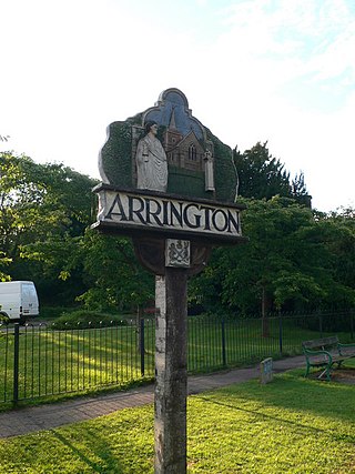
Arrington is a small village and civil parish in the South Cambridgeshire district of Cambridgeshire, England, with a population of 415 at the time of 2011 census. The village is 6 miles (10 km) north of Royston, Hertfordshire, and 9 miles (14 km) south-west of the county city of Cambridge.

Longstowe is a civil parish and small rural village of nearly 200 residents in South Cambridgeshire, England, 12 miles (19 km) west of Cambridge. The population was measured at 205 at the 2011 Census. It is situated on the western side of the A1198 road, running for about a mile along the B1046.

<span class="mw-page-title-main">Langford, Bedfordshire</span> Human settlement in England

Langford is a village and civil parish in the Central Bedfordshire district of the county of Bedfordshire, England about 10 miles (16 km) south-east of the county town of Bedford. The 2011 census gives the population as 3,091.

<span class="mw-page-title-main">Wrestlingworth</span> Human settlement in England

Wrestlingworth is a small, rural village in the Central Bedfordshire district of the county of Bedfordshire, England about 13 miles (21 km) east of the county town of Bedford. Wrestlingworth incorporates the hamlet of Water End, some half mile to the south of the village centre. At the 2011 census date it had a population of 591. It is in the civil parish of Wrestlingworth and Cockayne Hatley.

<span class="mw-page-title-main">Eyeworth</span> Human settlement in England

Eyeworth is a small, rural village and civil parish in the Central Bedfordshire district of the county of Bedfordshire, England; about 12.5 miles (20 km) east south-east of the county town of Bedford.

Croydon is a small village and civil parish in South Cambridgeshire, England. It is 10 miles (16 km) south-west of Cambridge and immediately west of the A1198 road. The population in 2001 was 221 people, increasing to 235 at the 2011 Census. The site of the deserted medieval village of Clopton is in Croydon parish, which was formerly known as Croydon-cum-Clopton.

<span class="mw-page-title-main">Tadlow</span> Human settlement in England

Tadlow is a small village and civil parish in South Cambridgeshire, England on the River Cam. It is 20 kilometres (12 mi) south-west of Cambridge and 9 kilometres (6 mi) north-east of Biggleswade, Bedfordshire. In 2001 the population was 181 and the area of the village is 681 hectares.

<span class="mw-page-title-main">Sutton, Bedfordshire</span> Human settlement in England

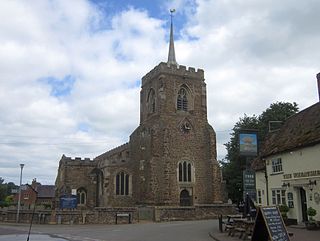
Sutton is a rural village and civil parish in the Central Bedfordshire district of Bedfordshire, England. It lies 11 miles (18 km) east of Bedford. At the 2001 Census, its population was 299. Main features are the packhorse bridge over the Potton Brook, the adjacent ford, and the Grade I listed All Saints' Parish Church.

<span class="mw-page-title-main">Grade I listed buildings in Somerset</span> Buildings of exceptional interest in Somerset

The Grade I listed buildings in Somerset, England, demonstrate the history and diversity of its architecture. The ceremonial county of Somerset consists of a non-metropolitan county, administered by Somerset County Council, which is divided into five districts, and two unitary authorities. The districts of Somerset are West Somerset, South Somerset, Taunton Deane, Mendip and Sedgemoor. The two administratively independent unitary authorities, which were established on 1 April 1996 following the breakup of the county of Avon, are North Somerset and Bath and North East Somerset. These unitary authorities include areas that were once part of Somerset before the creation of Avon in 1974.

References

  1. "Civil Parish population 2011". Neighbourhood Statistics. Office for National statistics. Retrieved 18 July 2016.
  2. 1 2 3 4 "Parishes: Hatley St. George". History of the County of Cambridge and the Isle of Ely: Volume 5 (1973). British History Online. Retrieved 13 July 2008.
  3. 1 2 3 "A brief history". Hatley.info. Retrieved 24 April 2009.
  4. Mills, A.D. (1998). A Dictionary of English Place-names. Oxford: Oxford University Press. p. 170. ISBN   0-19-280074-4.
  5. "About Hatley". Hatley.info. Retrieved 24 April 2009.
  6. "Hatley St George". Cambridgeshire History.com. Retrieved 24 April 2009.
  7. 1 2 "Hatley St George". Cambridgeshire. GENUKI. Retrieved 24 April 2009.
  8. "Hatley Parish Council". Hatley.info. Retrieved 16 July 2018.
  9. "Electoral wards". Council and democracy. South Cambridgeshire District Council. Archived from the original on 24 July 2008. Retrieved 16 July 2018.
  10. "Councillors". Democracy and decision making. Cambridgeshire County Council. Archived from the original on 13 May 2009. Retrieved 16 July 2018.
  11. 1 2 "1:25,000 mapping". getamap.co.uk. Ordnance Survey. Retrieved 24 April 2009.
  12. 1 2 "2001 Census Profile: Hatley Parish, South Cambridgeshire" (PDF). Cambridgeshire.gov.uk. Cambridgeshire County Council. Archived from the original (PDF) on 9 June 2011. Retrieved 24 April 2009.
  13. 1 2 3 4 5 "The Social Contribution of Land-based Industries to Rural Communities – Final report. Prepared for the Commission for Rural Communities by the Countryside and Community Research Unit, University of Gloucestershire" (PDF). Commission for Rural Communities. Archived from the original (PDF) on 7 November 2007. Retrieved 24 April 2009.
  14. "Shop and post office". Hatley.info. Retrieved 24 April 2009.
  15. 1 2 "History walk". Hatley.info. Retrieved 24 April 2009.
  16. "East Hatley". Cambridgeshire. GENUKI. Retrieved 24 April 2009.
  17. "Village hall". Hatley.info. Retrieved 24 April 2009.
  18. "Sir John Astor obituary". Guardian.co.uk. London: The Guardian. 13 September 2000. Retrieved 24 April 2009.
  19. "Lodge to Hatley Park". historicengland.org.uk. English Heritage. Retrieved 24 April 2009.
  20. "Model farmbuildings". historicengland.org.uk. English Heritage. Retrieved 24 April 2009.
  21. "Church of St George". historicengland.org.uk. English Heritage. Retrieved 24 April 2009.
  22. 1 2 "St George, Hatley St George". The Diocese of Ely. Archived from the original on 9 May 2008. Retrieved 24 April 2009.
  23. "St Denis Church, East Hatley". Haymills.com. Haymills Construction. Archived from the original on 23 September 2007. Retrieved 24 April 2009.
  24. "Church of St Denis". historicengland.org.uk. English Heritage. Retrieved 24 April 2009.
  25. "Buff Wood". Visit a reserve. The Wildlife Trust for Bedfordshire, Cambridgeshire, Northamptonshire and Peterborough. Archived from the original on 26 May 2011. Retrieved 7 February 2010.
  26. "Hayley Wood". Visit a reserve. The Wildlife Trust for Bedfordshire, Cambridgeshire, Northamptonshire and Peterborough. Archived from the original on 26 May 2011. Retrieved 7 February 2010.

Commons-logo.svg Media related to Hatley, Cambridgeshire at Wikimedia Commons