Haukeli

Last updated
Haukeli
Haukeligrend
Village
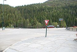
Haukeli, Rv9 og E134.JPG
View of the main intersection in the village
Norway Telemark adm location map.svg
Red pog.svg
Haukeli
Location of the village
Norway location map.svg
Red pog.svg
Haukeli
Haukeli (Norway)
Coordinates: 59°44′05″N7°33′06″E / 59.73482°N 7.55163°E / 59.73482; 7.55163
Country Norway
Region Eastern Norway
County Telemark
District Vest-Telemark
Municipality Vinje Municipality
Elevation
[1]
569 m (1,867 ft)
Time zone UTC+01:00 (CET)
  Summer (DST) UTC+02:00 (CEST)
Post Code
3895 Edland

Haukeli (or historically Haukeligrend) is a village in Vinje Municipality in Telemark county, Norway. The village is located up in the Haukelifjell mountains, just south of the Hardangervidda National Park and immediately west of the village of Edland. Haukeli is where Norwegian National Road 9 and European route E134 meet. It is the last larger village heading west before going over the mountain pass and entering Western Norway. Prior to 1999, the area was called Haukeligrend.

Haukeli hotell Haukeli hotell.JPG
Haukeli hotell

Popular activities in the area are fishing, hunting, hiking, and skiing. Haukelifjell is located about 12 kilometres (7.5 mi) to the west of Haukeli and it is a skiing destination at wintertime. [2]

Some of the rivers around Haukeli have been dammed to produce hydropower. Development started in 1957 with the construction of the Haukeli Power Station and was finished in 1979 when the system was all completed. [3]

Related Research Articles

<span class="mw-page-title-main">Telemark</span> Traditional region and former county (fylke) of Norway

Telemark is a county and a current electoral district in Norway. Telemark borders the counties of Vestfold, Buskerud, Vestland, Rogaland and Agder. In 2020, Telemark merged with the county of Vestfold to form the county of Vestfold og Telemark. On 1 January 2024, the county of Telemark was re-established after Vestfold og Telemark was divided again.

<span class="mw-page-title-main">Vinje</span> Municipality in Telemark, Norway

Vinje is a municipality in Telemark county, Norway. It is located in the traditional district of Vest-Telemark which is part of Øvre Telemark. The administrative centre of the municipality is the village of Åmot. Other villages in the municipality include Arabygdi, Edland, Grunge, Haukeli, Krossen, Møsstrond, Nesland, Øyfjell, Raulandsgrend, and Vinje.

<span class="mw-page-title-main">Bykle</span> Municipality in Agder, Norway

Bykle is a municipality in Agder county, Norway. It is located in the traditional district of Setesdal. The administrative centre of the municipality is the village of Bykle. Other villages in Bykle municipality include Berdalen, Bjåen, Breive, Hoslemo, Hovden, and Nordbygdi. Bykle was established as a municipality on 1 January 1902 when it was separated from the municipality of Valle.

<span class="mw-page-title-main">Rjukan</span> Town in Tinn, Norway

Rjukan is a town in Tinn Municipality in Vestfold og Telemark county, Norway. The town is also the administrative centre of Tinn Municipality. The town is located in the Vestfjorddalen valley, between the lakes Møsvatn and Tinnsjå. The municipal council of Tinn declared town status for Rjukan in 1996. The town is located about 10 kilometres (6.2 mi) to the west of the village of Miland and about 20 kilometres (12 mi) to the northwest of the village of Tuddal.

<span class="mw-page-title-main">Vest-Telemark</span> District in Telemark, Norway

Vest-Telemark is a traditional district in Norway. The 7,699-square-kilometre (2,973 sq mi) area comprises the western areas of the larger region known as Upper Telemark in Vestfold og Telemark county. The region consists of six municipalities: Fyresdal, Tokke, Vinje, Nissedal, Kviteseid, and Seljord. In 2020, there were 13,903 residents in the region. The area of Vest-Telemark was historically called Øvre Telemark vestfjelske.

<span class="mw-page-title-main">European route E134</span> Road in trans-European E-road network

European highway E 134 is a European highway that crosses Norway starting at Haugesund Airport, Karmøy near the city of Haugesund on the west coast, heading over Haukeli, passing the city of Drammen, and ending in Vassum on the east side of the Oslofjord Tunnel.

<span class="mw-page-title-main">Høydalsmo</span> Village in Tokke, Norway

Høydalsmo is a village in Tokke Municipality in Telemark county, Norway. The village is located along the north shore of the lake Oftevant in the northeastern part of the municipality. The European route E134 highway runs through the village. The village area has about 300 permanent residents. The village of Dalen lies about 15 kilometres (9.3 mi) to the southwest and the village of Åmot lies about 15 kilometres (9.3 mi) to the northwest.

<span class="mw-page-title-main">Guthega, New South Wales</span> Town in New South Wales, Australia

Guthega is an alpine village and the site for a hydro electric dam located in the Kosciuszko National Park, on the upper reaches of the Snowy River, on the western face of Mount Blue Cow, Snowy Mountains of New South Wales, Australia.

<span class="mw-page-title-main">Møsvatn</span> Lake in Telemark, Norway

Møsvatn or Møsvann is a lake in Vinje Municipality in Telemark county, Norway. It is the tenth-largest lake in Norway with a surface area of 79.1 square kilometres (30.5 sq mi) and a volume of 1,573,523,000 cubic metres (1,275,676 acre⋅ft). The lake lies just east of the Hardangervidda National Park, in Skien watershed (Skiensvassdrag) catchment area. The lake discharges into the Måna river at a dam located on the Vinje-Tinn municipal border. The lake has an irregular shape with three arms. The longest length across the lake is about 40 kilometres (25 mi). Møsvatn is a shallow mountain lake by Norwegian standards, reaching a maximum depth of 68.5 metres (225 ft).

<span class="mw-page-title-main">Bygdin</span> Lake in Innlandet, Norway

Bygdin is a lake in Vang Municipality in Innlandet county, Norway. The 40-square-kilometre (15 sq mi) is located in the southern part of the Jotunheimen mountain range. The 25-kilometre (16 mi) long, narrow mountain lake is located between the large lakes Tyin and Vinstre to the east.

<span class="mw-page-title-main">Totak</span> Lake in Telemark, Norway

Totak is a lake in Vinje Municipality in Telemark county, Norway. The 37.26-square-kilometre (14.39 sq mi) lake is located in the Rauland area, about 10 kilometres (6.2 mi) to the north of the village of Åmot. The lake is part of the Skien river watershed (Skiensvassdraget), discharging via the river Tokke which flows into the lake Bandak to the south. At 306 metres (1,004 ft) deep, Totak is the 11th deepest lake in Norway. This tremendous overdeepening marks it as a glacially formed lake with characteristics similar to a fjord. Its volume of 2.35 cubic kilometres (1,910,000 acre⋅ft) makes it the 24th largest by volume as well. Totak is Norway's deepest lake; that isn't a cryptodepression. The lake's basin is well over sealevel. The lake is a reservoir that holds water for the Tokke Hydroelectric Power Station.

<span class="mw-page-title-main">Øyfjell</span> Village in Vinje, Norway

Øyfjell is a village in Vinje Municipality in Telemark county, Norway. The village is located in the southeastern part of the municipality, along the river Vikåi, about 15 kilometres (9.3 mi) to the east of the village of Åmot. Øyfjell Church is located in the village.

Edland is a village in Vinje Municipality in Telemark county, Norway. The village is located where the rivers Bora and Kjela meet, just to the east of the village of Haukeli. The European route E134 highway runs through the village. The village of Grunge is located about 8 kilometres (5.0 mi) to the southeast and the village of Arabygdi lies about 10 kilometres (6.2 mi) to the northeast. Aasmund Olavsson Vinje took the plot of his epic poem about "Storegut" from Edland.

<span class="mw-page-title-main">Songavatnet</span> Lake in Telemark, Norway

Songavatnet is a lake in Vinje Municipality in Telemark county, Norway. It has a surface area of 29.86 square kilometres (11.53 sq mi) and lies at an elevation of 974 metres (3,196 ft). The lake lies just south of the border of Hardangervidda National Park and just southeast of the mountain Vassdalseggi. The villages of Haukeli and Edland are both located about 9 kilometres (5.6 mi) to the south of the lake and the village of Arabygdi lies about 10 kilometres (6.2 mi) to the southeast of the lake. The lake flows out into the river Songa which flows to the southeast into the nearby lake Totak.

<span class="mw-page-title-main">Norwegian National Road 9</span> Road in Norway

Norwegian National Road 9 is often called the Setesdal Road and it is the main thoroughfare through the Setesdalen valley. It runs from the city of Kristiansand in the southern coast of Norway, through the Torridal and Setesdal valleys in Agder county to Haukeligrend in Vestfold og Telemark county in the north where it meets the European route E134 highway. The highway goes through the villages of Mosby, Homstean, Skarpengland, Hægeland, Hornesund, Hornnes, Evje, Byglandsfjord, Bygland, Ose, Rysstad, Valle, Flatland, Rygnestad, Bykle, Hovden, Bjåen, and Haukeli.

Bjåen or Bjåi is a small village in Bykle municipality in Agder county, Norway. The village is located along the Norwegian National Road 9. The village sits on the north shore of the lake Breidvatn, about 12 kilometres (7.5 mi) north of the village of Hovden and about 15 kilometres (9.3 mi) south of Haukeli in neighboring Vinje municipality in Telemark county to the north. The area is primarily agricultural, specializing in sheep herding rather than growing crops, but Bjåen is probably best known for the Bjåen tourist lodge in the high mountain area.

<span class="mw-page-title-main">Haukelifjell</span>

Haukelifjell is a mountain area and a mountain pass in South Norway. The area is located in Vinje municipality in the county of Telemark and Odda municipality in the county of Hordaland. The mountain area partially overlaps the Hardangervidda mountain plateau, and is defined by the villages of Røldal to the west and Haukeli in the east.

<span class="mw-page-title-main">Arabygdi</span> Village in Vinje, Norway

Arabygdi is a village in Vinje Municipality in Telemark county, Norway. The village is located in the Rauland area at the western end of the lake Totak. The Norwegian County Road 362 passes through the village, connecting it to the villages of Haukeli and Raulandsgrend. The road passes through the Urdbøuri scree area, just west of Arabygdi.

<span class="mw-page-title-main">Raulandsgrend</span> Village in Vinje, Norway

Raulandsgrend or simply Rauland is a village in Vinje Municipality in Telemark county, Norway. The village is located in a mountainous area along the north shore of the lake Totak, about 4.5 kilometres (2.8 mi) to the northwest of the village of Krossen. The lake Møsvatn lies about 10 kilometres (6.2 mi) to the north and the vast Hardangervidda National Park lies about 20 kilometres (12 mi) to the northwest. The village was once the administrative centre of the old Rauland Municipality which existed from 1860 until 1964.

<span class="mw-page-title-main">Grunge, Norway</span> Village in Vinje, Norway

Grunge is a village in Vinje Municipality in Telemark county, Norway. The village is located on the north shore of the lake Tveitevatnet, about 12 kilometres (7.5 mi) to the east of the villages of Haukeli and Edland. The European route E134 highway runs through the village. Grunge Church is located a short distance west of the village.

References

  1. "Haukeli, Vinje". yr.no . Retrieved 2 January 2023.
  2. Lundbo, Sten, ed. (22 December 2020). "Haukelifjell". Store norske leksikon (in Norwegian). Kunnskapsforlaget . Retrieved 2 January 2023.
  3. "Haukeli power plant". Statkraft. Retrieved 2 January 2023.