An arch bridge is a bridge with abutments at each end shaped as a curved arch. Arch bridges work by transferring the weight of the bridge and its loads partially into a horizontal thrust restrained by the abutments at either side, and partially into a vertical load on the arch supports. A viaduct may be made from a series of arches, although other more economical structures are typically used today.

The Prince Edward Viaduct System, commonly referred to as the Bloor Viaduct, is the name of a truss arch bridge system in Toronto, Ontario, Canada, connecting Bloor Street East, on the west side of the system, with Danforth Avenue on the east. The system includes the Rosedale Valley phase and the Sherbourne Phase, an embankment built to extend Bloor Street East to the Rosedale Ravine from Sherbourne Street. The Don Valley phase of the system, the most recognizable, spans the Don River Valley, crossing over the Bayview Avenue Extension, the Don River, and the Don Valley Parkway.
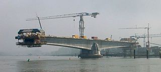
A cantilever bridge is a bridge built using structures that project horizontally into space, supported on only one end. For small footbridges, the cantilevers may be simple beams; however, large cantilever bridges designed to handle road or rail traffic use trusses built from structural steel, or box girders built from prestressed concrete.

A truss bridge is a bridge whose load-bearing superstructure is composed of a truss, a structure of connected elements, usually forming triangular units. The connected elements, typically straight, may be stressed from tension, compression, or sometimes both in response to dynamic loads. There are several types of truss bridges, including some with simple designs that were among the first bridges designed in the 19th and early 20th centuries. A truss bridge is economical to construct primarily because it uses materials efficiently.

The Ross Island Bridge is a cantilever truss bridge that spans the Willamette River in Portland, Oregon. It carries U.S. Route 26 across the river between southwest and southeast Portland. The bridge opened in 1926 and was designed by Gustav Lindenthal and honors Oregon pioneer Sherry Ross. It is named for its proximity to Ross Island. Although it looks like a deck arch bridge, it is a cantilever deck truss bridge, a rare type in Oregon.
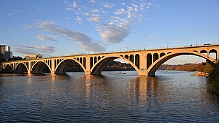
The Francis Scott Key Bridge, more commonly known as the Key Bridge, is a six-lane reinforced concrete arch bridge carrying U.S. Route 29 (US 29) across the Potomac River between the Rosslyn neighborhood of Arlington County, Virginia, and the Georgetown neighborhood of Washington, D.C. Completed in 1923, it is Washington's oldest surviving road bridge across the Potomac River.

A truss arch bridge combines the elements of the truss bridge and the arch bridge. The actual resolution of forces will depend upon the bridge' design. If no horizontal thrusting forces are generated, this becomes an arch-shaped truss which is essentially a bent beam – see moon bridge for an example. If horizontal thrust is generated but the apex of the arch is a pin joint, this is termed as a three-hinged arch. If no hinge exists at the apex, it will normally be a two-hinged arch.
The Macombs Dam Bridge is a swing bridge across the Harlem River in New York City, connecting the boroughs of Manhattan and the Bronx. The bridge is operated and maintained by the New York City Department of Transportation (NYCDOT).
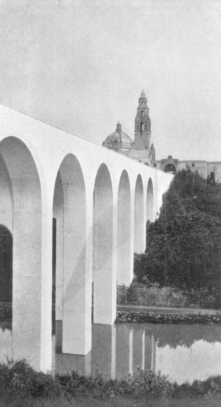
The Cabrillo Bridge is a historic bridge in San Diego, California, providing pedestrian and light automotive access between Balboa Park and the uptown area of San Diego. It was built for the Panama–California Exposition of 1915. The bridge was nominated for the National Register of Historic Places in 1976 and was named a Local Historic Civil Engineering Landmark by the American Society of Civil Engineers in 1986.

The Detroit–Superior Bridge or Detroit–Superior High Level Bridge is a 3,112-foot-long (949 m) through arch bridge over the Cuyahoga River in Cleveland, Ohio. The bridge links Detroit Avenue on Cleveland's west side and Superior Avenue on Cleveland's east side, terminating west of Public Square. Construction by the King Bridge Company began in 1914 and completed in 1918, at a cost of $5.4 million. It was the first fixed high level bridge in Cleveland, and the third high-level bridge above the Cuyahoga. At the time of its completion, the bridge was the largest steel and concrete reinforced bridge in the world.
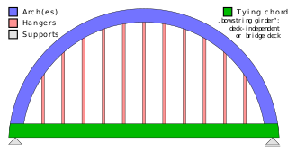
A tied-arch bridge is an arch bridge in which the outward-directed horizontal forces of the arch(es) are borne as tension by a chord tying the arch ends rather than by the ground or the bridge foundations. This strengthened chord may be the deck structure itself or consist of separate, independent tie-rods.

Squire Whipple was an American civil engineer.

The Elizabethton Covered Bridge is a 134-foot (41 m) covered bridge over the Doe River in Elizabethton, the county seat of Carter County, Tennessee.

The 19th Street Bridge is a two-span through Pratt truss road bridge in Denver, Colorado, over the South Platte River, now used for pedestrians. It was built in 1888 to replace a wooden structure and carried automobile traffic until 1986. The bridge is listed on the National Register of Historic Places.
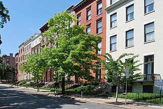
The Lafayette Park Historic District is located in central Albany, New York, United States. It includes the park and the combination of large government buildings and small rowhouses on the neighboring streets. In 1978 it was recognized as a historic district and listed on the National Register of Historic Places (NRHP). Many of its contributing properties are themselves listed on the National Register. One of them, the New York State Capitol, is a National Historic Landmark as well. Other government buildings include City Hall, the building housing Albany County government, the state's highest court and the offices of its Education Department along with the offices of the City School District of Albany. The Episcopal Diocese of Albany's cathedral is at one corner of the district.

Sheridan Hollow is a neighborhood in Albany, New York located in a ravine north of Downtown Albany. Capitol Hill to the south and Arbor Hill to the north flank the ravine. Often the neighborhood is overlooked by city residents, and outsiders who work in the neighborhood often don't recognize the name of the neighborhood. This is due to the identity of the Hollow being subsumed into its larger neighbor Arbor Hill, for instance news stories of events are often accredited to the wrong neighborhood. Being on undesirable land for development in colonial times, growth was slow in the Hollow and the neighborhood was populated through the centuries by a series of ethnic groups new to Albany, such as the Irish, Polish, and African Americans.

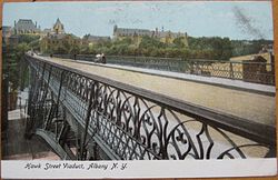
Corby Bridge is a railway viaduct adjacent to and immediately east of Wetheral railway station at Wetheral, near Carlisle, in north-western England, begun in 1830 and completed in 1834. It is 920 feet (280 m) long and 100 feet (30 m) high, and has been a Grade I listed building since 1 April 1957.
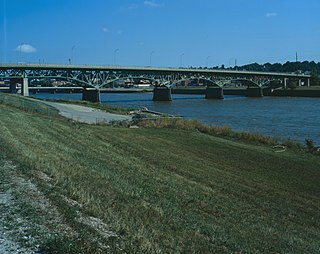
The Jefferson Street Viaduct is a historic structure located in Ottumwa, Iowa, United States. The riveted Warren deck truss bridge was completed in 1936. It was listed on the National Register of Historic Places in 1998 as a part of the Highway Bridges of Iowa MPS.

The San Jacinto Street Bridge is a viaduct which crosses Buffalo Bayou in Houston, Texas. The structure is listed on the National Register of Historic Places (NRHP). This bridge was built in 1914 to replace an iron pivot bridge of 1883 origin, and rehabilitated in 1997. It is a transportation conduit connecting downtown and the historical Fifth Ward.

The West Fifth Street Bridge is a historic cantilever concrete girder bridge in downtown Austin, Texas. Built in 1931, the bridge carries Fifth Street across Shoal Creek to link central Austin with neighborhoods that were then the city's western suburbs. It is one of only a handful of curved cantilever girder bridges in Texas, built as part of the city's 1928 master plan for urban development and beautification. The bridge was added to the National Register of Historic Places in 2019.