
Arable land is any land capable of being ploughed and used to grow crops. Alternatively, for the purposes of agricultural statistics, the term often has a more precise definition:
Arable land is the land under temporary agricultural crops, temporary meadows for mowing or pasture, land under market and kitchen gardens and land temporarily fallow. The abandoned land resulting from shifting cultivation is not included in this category. Data for 'Arable land' are not meant to indicate the amount of land that is potentially cultivable.

Hay is grass, legumes, or other herbaceous plants that have been cut and dried to be stored for use as animal fodder, either for large grazing animals raised as livestock, such as cattle, horses, goats, and sheep, or for smaller domesticated animals such as rabbits and guinea pigs. Pigs can eat hay, but do not digest it as efficiently as herbivores do.

Intensive agriculture, also known as intensive farming, conventional, or industrial agriculture, is a type of agriculture, both of crop plants and of animals, with higher levels of input and output per unit of agricultural land area. It is characterized by a low fallow ratio, higher use of inputs such as capital, labour, agrochemicals and water, and higher crop yields per unit land area.
The British Agricultural Revolution, or Second Agricultural Revolution, was an unprecedented increase in agricultural production in Britain arising from increases in labor and land productivity between the mid-17th and late 19th centuries. Agricultural output grew faster than the population over the hundred-year period ending in 1770, and thereafter productivity remained among the highest in the world. This increase in the food supply contributed to the rapid growth of population in England and Wales, from 5.5 million in 1700 to over 9 million by 1801, though domestic production gave way increasingly to food imports in the 19th century as the population more than tripled to over 35 million.
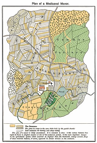
The open-field system was the prevalent agricultural system in much of Europe during the Middle Ages and lasted into the 20th century in Russia, Iran, and Turkey. Each manor or village had two or three large fields, usually several hundred acres each, which were divided into many narrow strips of land. The strips or selions were cultivated by peasants, often called tenants or serfs. The holdings of a manor also included woodland and pasture areas for common usage and fields belonging to the lord of the manor and the religious authorities, usually Roman Catholics in medieval Western Europe. The farmers customarily lived in separate houses in a nucleated village with a much larger manor house and church nearby. The open-field system necessitated co-operation among the residents of the manor.

A grassland is an area where the vegetation is dominated by grasses (Poaceae). However, sedge (Cyperaceae) and rush (Juncaceae) can also be found along with variable proportions of legumes, like clover, and other herbs. Grasslands occur naturally on all continents except Antarctica and are found in most ecoregions of the Earth. Furthermore, grasslands are one of the largest biomes on Earth and dominate the landscape worldwide. There are different types of grasslands: natural grasslands, semi-natural grasslands, and agricultural grasslands. They cover 31–69% of the Earth's land area.

Animal husbandry is the branch of agriculture concerned with animals that are raised for meat, fibre, milk, or other products. It includes day-to-day care, management, production, nutrition, selective breeding, and the raising of livestock. Husbandry has a long history, starting with the Neolithic Revolution when animals were first domesticated, from around 13,000 BC onwards, predating farming of the first crops. During the period of ancient societies like ancient Egypt, cattle, sheep, goats, and pigs were being raised on farms.

Pasture is land used for grazing.

A meadow is an open habitat or field, vegetated by grasses, herbs, and other non-woody plants. Trees or shrubs may sparsely populate meadows, as long as these areas maintain an open character. Meadows can occur naturally under favourable conditions, but are often artificially created from cleared shrub or woodland for the production of hay, fodder, or livestock. Meadow habitats, as a group, are characterized as "semi-natural grasslands", meaning that they are largely composed of species native to the region, with only limited human intervention.

The Agricultural Revolution in Scotland was a series of changes in agricultural practice that began in the 17th century and continued in the 19th century. They began with the improvement of Scottish Lowlands farmland and the beginning of a transformation of Scottish agriculture from one of the least modernised systems to what was to become the most modern and productive system in Europe. The traditional system of agriculture in Scotland generally used the runrig system of management, which had possibly originated in the Late Middle Ages. The basic pre-improvement farming unit was the baile and the fermetoun. In each, a small number of families worked open-field arable and shared grazing. Whilst run rig varied in its detail from place to place, the common defining detail was the sharing out by lot on a regular basis of individual parts ("rigs") of the arable land so that families had intermixed plots in different parts of the field.

In agriculture, grazing is a method of animal husbandry whereby domestic livestock are allowed outdoors to free range and consume wild vegetations in order to convert the otherwise indigestible cellulose within grass and other forages into meat, milk, wool and other animal products, often on land that is unsuitable for arable farming.

Panicum virgatum, commonly known as switchgrass, is a perennial warm season bunchgrass native to North America, where it occurs naturally from 55°N latitude in Canada southwards into the United States and Mexico. Switchgrass is one of the dominant species of the central North American tallgrass prairie and can be found in remnant prairies, in native grass pastures, and naturalized along roadsides. It is used primarily for soil conservation, forage production, game cover, as an ornamental grass, in phytoremediation projects, fiber, electricity, heat production, for biosequestration of atmospheric carbon dioxide, and more recently as a biomass crop for ethanol and butanol.

Henfield is a large village and civil parish in the Horsham District of West Sussex, England. It lies 41 miles (66 km) south of London, 12 miles (19 km) northwest of Brighton, and 30 miles (48 km) east northeast of the county town of Chichester at the road junction of the A281 and A2037. The parish has a land area of 4,285 acres (1,734.1 ha). In the 2001 census 5,012 people lived in 2,153 households, of whom 2,361 were economically active. Other nearby towns include Burgess Hill to the east and Shoreham-by-Sea to the south. The population at the 2011 Census was 5,349.
In agriculture, a field is an area of land, enclosed or otherwise, used for agricultural purposes such as cultivating crops or as a paddock or other enclosure for livestock. A field may also be an area left to lie fallow or as arable land.
Whitton Bridge Pasture is a Site of Special Scientific Interest (SSSI) in the unitary authority of Stockton-on-Tees, England. At 3.18 hectares (7.9 acres) it lies to the south of Whitton village and north west of Stockton-on-Tees. SSSIs are chosen by Natural England, and Whitton Bridge Pasture was designated in 2004 because of its biological interest. It is one of 18 SSSIs in the Cleveland area of search.

North Meadow, Cricklade is a hay meadow near the town of Cricklade, in Wiltshire, England. It is 24.6 hectares in size. It is a traditionally managed lowland hay-meadow, or lammas land, and is grazed in common between 12 August and 12 February each year, and cut for hay no earlier than 1 July. This pattern of land use and management has existed for many centuries and has resulted in the species rich grassland flora and fauna present on the site.

Agriculture in Wales has in the past been a major part of the economy of Wales, a largely rural country which is part of the United Kingdom. Wales is mountainous and has a mild, wet climate. This results in only a small proportion of the land area being suitable for arable cropping, but grass for the grazing of livestock is present in abundance. As a proportion of the national economy, agriculture is now much less important; a high proportion of the population now live in the towns and cities in the south of the country and tourism has become an important form of income in the countryside and on the coast. Arable cropping is limited to the flatter parts and elsewhere dairying and livestock farming predominate.
Wales has a surface area of 2,628,779 km2 or 2,077,900 ha. It has a border with England to the east, and is bounded by the Irish Sea to the north and west, and by the Bristol Channel to the south. It has an oceanic temperate climate which is markedly influenced by the North Atlantic Current carrying warm water from tropical latitudes. As a result, it has a much milder climate than most places in the world at similar latitudes. Altitudes range from sea-level to 10985 m on the Snowdon Massif.
This glossary of agriculture is a list of definitions of terms and concepts used in agriculture, its sub-disciplines, and related fields, including horticulture, animal husbandry, agribusiness, and agricultural policy. For other glossaries relevant to agricultural science, see Glossary of biology, Glossary of ecology, Glossary of environmental science, and Glossary of botanical terms.
Dunsdon National Nature Reserve is a nature reserve of the Devon Wildlife Trust, near Dunsdon and about 3.5 miles (5.6 km) north-west of Holsworthy, in Devon, England. The habitat is culm grassland.
