Haynes, North Dakota

Last updated

Haynes, North Dakota
Haynes, North Dakota.jpg
Haynes, North Dakota
Adams County Haynes.svg
Location of Haynes, North Dakota
Coordinates: 45°58′26″N102°28′16″W / 45.97389°N 102.47111°W / 45.97389; -102.47111
CountryUnited States
State North Dakota
County Adams
Founded as Gadsden1906
Founded as Haynes1907
Area
[1]
  Total0.14 sq mi (0.35 km2)
  Land0.14 sq mi (0.35 km2)
  Water0.00 sq mi (0.00 km2)
Elevation
[2]
2,543 ft (775 m)
Population
 (2020) [3]
  Total15
  Estimate 
(2022) [4]
15
  Density111.11/sq mi (42.86/km2)
Time zone UTC-7 (Mountain (MST))
  Summer (DST) UTC-6 (MDT)
ZIP code
58639
Area code 701
FIPS code 38-36540
GNIS feature ID1036087 [2]

Haynes is a city in Adams County, North Dakota, United States. The population was 15 at the 2020 census. [3]

Contents

Haynes was founded as Gadsden in 1906 along the Milwaukee Road's transcontinental rail line known as the Pacific Extension. The name was changed to Haynes in 1907 to honor George B. Haynes, president of the Milwaukee Road at the time. [5]

Geography

Haynes is located just north of the Grand River National Grassland. [6]

According to the United States Census Bureau, the city has a total area of 0.14 square miles (0.36 km2), all land. [7]

Demographics

Historical population
CensusPop.Note
1920 113
1930 16747.8%
1940 21025.7%
1950 145−31.0%
1960 111−23.4%
1970 53−52.3%
1980 589.4%
1990 37−36.2%
2000 19−48.6%
2010 2321.1%
2020 15−34.8%
2022 (est.)15 [4] 0.0%
U.S. Decennial Census [8]
2020 Census [3]

2010 census

At the 2010 census, there were 23 people, 13 households and 6 families residing in the city. The population density was 164.3 inhabitants per square mile (63.4/km2). There were 16 housing units at an average density of 114.3 per square mile (44.1/km2). The racial makeup of the city was 78.3% White and 21.7% Native American.

There were 13 households, of which 7.7% had children under the age of 18 living with them, 46.2% were married couples living together, and 53.8% were non-families. 46.2% of all households were made up of individuals, and 7.7% had someone living alone who was 65 years of age or older. The average household size was 1.77 and the average family size was 2.50.

The median age in the city was 55.3 years. 13% of residents were under the age of 18; 4.2% were between the ages of 18 and 24; 13% were from 25 to 44; 30.3% were from 45 to 64; and 39.1% were 65 years of age or older. The sex makeup of the city was 52.2% male and 47.8% female.

2000 census

At the 2000 census, there were 19 people, 10 households and 5 families residing in the city. The population density was 143.4 inhabitants per square mile (55.4/km2). There were 15 housing units at an average density of 113.2 per square mile (43.7/km2). The racial makeup of the city was 89.47% White, and 10.53% from two or more races.

There were 10 households, of which none had children under the age of 18 living with them, 50.0% were married couples living together, and 50.0% were non-families. 40.0% of all households were made up of individuals, and 20.0% had someone living alone who was 65 years of age or older. The average household size was 1.90 and the average family size was 2.60.

10.5% of the population were under the age of 18, 15.8% from 25 to 44, 47.4% from 45 to 64, and 26.3% who were 65 years of age or older. The median age was 60 years. For every 100 females, there were 90.0 males. For every 100 females age 18 and over, there were 88.9 males.

The median household income was $8,750 and the median family income for a family was $8,750. Males had a median income of $13,750 compared with $0 for females. The per capita income for the city was $6,633. Below the poverty line were 77.8% of people, 100.0% of families, none of those under 18 and 100.0% of those over 64.

Related Research Articles

<span class="mw-page-title-main">Warm River, Idaho</span> City in Idaho, United States

Warm River is a city in Fremont County, Idaho, United States. The population was 3 at the 2010 census, making it the least populous city in Idaho. It is part of the Rexburg, Idaho Micropolitan Statistical Area.

<span class="mw-page-title-main">Warwick, North Dakota</span> City in North Dakota, United States

Warwick is a city in Benson County, North Dakota, United States. The population was 55 at the 2020 census. Warwick was founded in 1907.

<span class="mw-page-title-main">Kramer, North Dakota</span> City in North Dakota, United States

Kramer is a city in Bottineau County, North Dakota, United States. The population was 24 at the 2020 census. Kramer was founded in 1905.

<span class="mw-page-title-main">Landa, North Dakota</span> City in North Dakota, United States

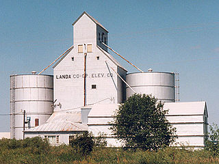
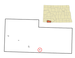
Landa is a city in Bottineau County, North Dakota, United States. The population was 41 at the 2020 census. Landa was founded in 1904.

<span class="mw-page-title-main">Lincoln, North Dakota</span> City in North Dakota, United States

Lincoln is a city in Burleigh County, North Dakota, United States. It is a suburb of adjacent Bismarck, and also a core city of the Bismarck-Mandan Metropolitan Statistical Area. The population was 4,257 at the 2020 census, making it the 14th most populous city in North Dakota. Lincoln was founded in 1977.

<span class="mw-page-title-main">Alice, North Dakota</span> City in North Dakota, United States

Alice is a city in Cass County, North Dakota, United States. The population was 41 at the 2020 census.

<span class="mw-page-title-main">Briarwood, North Dakota</span> City in North Dakota, United States

Briarwood is a city in Cass County, North Dakota, United States. The population was 57 at the 2020 census. Briarwood was founded in 1973. It is a suburb directly adjacent to the city of Fargo.

<span class="mw-page-title-main">Calio, North Dakota</span> City in North Dakota, United States

Calio is a city in Cavalier County, North Dakota, United States. The population was 8 at the 2020 census. Calio was founded in 1905.

<span class="mw-page-title-main">Ambrose, North Dakota</span> City in North Dakota, United States

Ambrose is a city in Divide County, North Dakota, United States. The population was 24 at the 2020 census. Ambrose was founded in 1906.

<span class="mw-page-title-main">Bergen, North Dakota</span> City in North Dakota, United States

Bergen is a city in McHenry County, North Dakota, United States. The population was 10 at the 2020 census. It is part of the Minot Micropolitan Statistical Area. Bergen was founded in 1905 and named after Bergen, Norway.

<span class="mw-page-title-main">Hoople, North Dakota</span> City in North Dakota, United States

Hoople is a city in Walsh County, North Dakota, United States. The population was 247 at the 2020 census. Hoople, named for early settler Alan Hoople, was founded in 1889. Hoople's nickname is "Tatertown."

<span class="mw-page-title-main">Kenmare, North Dakota</span> City in North Dakota, United States

Kenmare is a city in Ward County, North Dakota, United States. The population was 961 at the 2020 census. Kenmare is part of the Minot Micropolitan Statistical Area.

<span class="mw-page-title-main">White, South Dakota</span> City in South Dakota, United States

White is a city in Brookings County, South Dakota, United States. The population was 537 at the 2020 census.

<span class="mw-page-title-main">Corsica, South Dakota</span> City in South Dakota, United States

Corsica is a city in Douglas County, South Dakota, United States. The population was 561 at the 2020 census.

<span class="mw-page-title-main">Milltown, South Dakota</span> CDP in South Dakota, United States

Milltown is a census-designated place (CDP) in Hutchinson County, South Dakota, United States. The population was 8 at the 2020 census.

<span class="mw-page-title-main">Parkston, South Dakota</span> City in South Dakota, United States

Parkston is a city in Hutchinson County, South Dakota, United States. The population was 1,567 at the 2020 census.

<span class="mw-page-title-main">Presho, South Dakota</span> City in South Dakota, United States

Presho is a small city in Lyman County, South Dakota, United States. The population was 472 at the 2020 census.

<span class="mw-page-title-main">Leola, South Dakota</span> City in South Dakota, United States

Leola is a small city in, and the county seat of, McPherson County, South Dakota, United States. It was founded on May 1, 1884, and named for Leola Haynes, daughter of one of the town's founders. The population was 434 as of the 2020 census.

<span class="mw-page-title-main">Crooks, South Dakota</span> City in South Dakota, United States

Crooks is a city in Minnehaha County, South Dakota, United States and is a suburb of Sioux Falls. The population was 1,362 at the 2020 census. Crooks was named New Hope until 1904. The town's present name honors W. A. Crooks, a local politician.

<span class="mw-page-title-main">Vining, Kansas</span> City in Clay and Washington Counties in Kansas

Vining is a city in Clay and Washington counties in Kansas, United States. As of the 2020 census, the population of the city was 43.

References

  1. "ArcGIS REST Services Directory". United States Census Bureau. Retrieved September 20, 2022.
  2. 1 2 U.S. Geological Survey Geographic Names Information System: Haynes, North Dakota
  3. 1 2 3 "Explore Census Data". United States Census Bureau . Retrieved December 14, 2023.
  4. 1 2 "City and Town Population Totals: 2020-2022". United States Census Bureau. December 14, 2023. Retrieved December 14, 2023.
  5. Wick, Douglas A. "Haynes (Adams County)". North Dakota Place Names. Retrieved May 7, 2011.
  6. Map of the Grand River National Grassland
  7. "US Gazetteer files 2010". United States Census Bureau . Retrieved June 14, 2012.
  8. United States Census Bureau. "Census of Population and Housing" . Retrieved January 21, 2014.