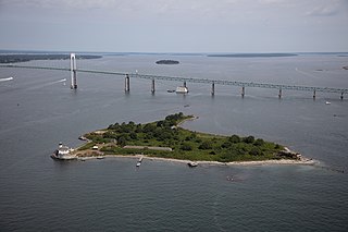
Jamestown is a town in Newport County, Rhode Island in the United States. The population was 5,559 at the 2020 census. Jamestown is situated almost entirely on Conanicut Island, the second largest island in Narragansett Bay. It also includes the uninhabited Dutch Island and Gould Island.

Kingston is a village and a census-designated place within the town of South Kingstown in Washington County, Rhode Island, United States, and the site of the main campus of the University of Rhode Island. The population was 6,974 at the 2010 census. Much of the village center is listed on the National Register of Historic Places as Kingston Village Historic District. It was originally known as Little Rest.
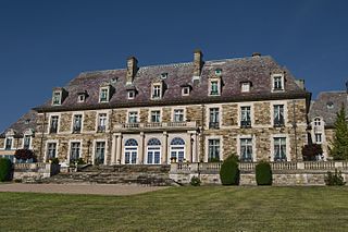
Aldrich Mansion is a late 19th-century property owned by the Roman Catholic Diocese of Providence since 1939. It is located by the scenic Narragansett Bay at 836 Warwick Neck Avenue in Warwick, Rhode Island, south of Providence, Rhode Island. Originally called Indian Oaks, and once the Senator Nelson W. Aldrich Estate. The extensive estate was developed in 1899 by Nelson W. Aldrich (1841–1915), a Republican Party politician who dominated state politics of the period. The main estate house is a sprawling stone French Renaissance structure with lavish interior decoration. The estate's surviving outbuildings include a boathouse and a caretaker's house, the latter located across Warwick Neck Avenue from the main estate. Aldrich's heirs sold the property to the Roman Catholic church in 1939, and it was adapted for use as a seminary. The property now known as "The Aldrich Mansion" still belongs to the Diocese of Providence, and is now available as a site for weddings, formal occasions, business conferences, etc. It is also occasionally used for film and television productions.

The Battle of Rhode Island Site is the partially preserved location of the Battle of Rhode Island, fought August 29, 1778 during the American Revolutionary War. The battle took place in the town of Portsmouth, Rhode Island, located on Aquidneck Island north of Newport, and was the only major action of the war that took place in Rhode Island. It was also significant as the only battle of the war in which an entirely segregated unit of African-American soldiers fought. At the time of the action, the 1st Rhode Island Regiment consisted of companies of locally recruited African Americans and Native Americans with white officers. The two main areas associated with the battle were designated a National Historic Landmark in 1974.
Albion is a village and historic district in Lincoln, Rhode Island, in the United States.

Mount Hope Farm is a historic estate on Metacom Avenue in Bristol, Rhode Island, United States.
The Windmill Hill Historic District is a historic district encompassing a large rural landscape in Jamestown, Rhode Island. It is bounded on the north by Eldred Avenue, on the east by East Shore Road, on the south by Great Creek, and on the west by Narragansett Bay. The area's historical resources included six farmsteads, as well as the Quaker Meetinghouse, the Jamestown Windmill, and its associated miller's house and barn. The area is predominantly rolling hills with open pastureland and forest. The district was listed on the National Register of Historic Places in 1978. The area is also rich in prehistoric evidence of Native American occupation, which is the subject of the Jamestown Archeological District listing on the National Register.
The Conanicut Battery is a colonial and 20th century military battery in Jamestown, Rhode Island, west of Beaver Tail Road. The site offers a commanding view of the West Passage of Narragansett Bay.
The Jamestown Archeological District is an expansive archaeological district which is the site of a major prehistoric Native American settlement in Jamestown, Rhode Island. The full extent of archaeologically-sensitive areas has not been fully identified, but is known to extend from Narragansett Avenue in the south to Rhode Island Route 138 in the north, and from Narragansett Bay in the west to North Road. The district overlaps the historically significant Windmill Hill Historic District, and the nearly 300-acre (120 ha) Watson Farm. The district includes one of largest Native American burying grounds in New England, and includes evidence of occupation dating to 3,000 BC.
Old Friends Archeological Site is an archaeological historical site in Jamestown, Rhode Island.
Pine Hill Archeological Site, RI-655 is a prehistoric archaeological site on Prudence Island in Portsmouth, Rhode Island. The site's principal feature is a coastal shell midden dating to the Late Woodland period. Finds at the site include projectile points, stone tools, bones, and ceramics.

The Ashton Historic District is a historic district in Cumberland, Rhode Island. The district consists of a mill and an adjacent mill village that was built for the workers of the mill. It lies between Mendon Road, Scott Road, Angell Road, Store Hill Road, Front Street and Middle Street. The district was added to the National Register of Historic Places on November 1, 1984.
Black Farm, also known as the Isaac Collins Farm, is a historic farm in Hopkinton, Rhode Island bounded by Woodville Alton Road and Wood Road. The 264-acre (107 ha) plot was developed by John Collins beginning in 1710 and saw agricultural use for over 200 years. The main house dates to the late 18th century, and is a 1-1/2 story gambrel-roofed post-and-beam structure. Outbuildings include 19th century barns, a corn crib, and a guest cottage added in the 1930s. Set some distance off from this complex is the foundational remains of what was probably an ice house; it consists of granite blocks and is eight feet high.

Hillsdale Historic and Archeological District is a historic district in Richmond, Rhode Island. The district was added to the National Register of Historic Places in 1980. It represents the site of the former textile mill village of Hillsdale.

Queen's Fort is a historic site in Exeter, Rhode Island. Little more than a round, rocky hillock, the site has long been described as the site of a Native American fortification constructed in 1676 by Queen Quaiapen and members of the Narragansett Indian Tribe who survived the Great Swamp Massacre.
Trafalgar Site, RI-639 is a prehistoric archaeological site in Warwick, Rhode Island. The site's primary component is a shell midden. Finds at the site include stone tools, bone, and tools for working bone.
The Thomas Carr Farmstead Site is a historic archaeological site in Jamestown, Rhode Island. Located in the vicinity of Tashtassuc Road and Eldred Avenue, the site was the farmstead for the locally prominent Carr family from the late 18th century into the 19th century.
Lippitt, Rhode Island is a village within the town of West Warwick, Rhode Island.
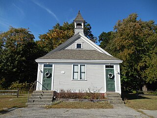
Belknap School is a historic former school house at 509 Greenville Avenue in the Belknap village of Johnston, Rhode Island.