
The Calder and Hebble Navigation is a broad inland waterway, with locks and bridge holes that are suitable for 14-foot-wide (4.3 m) boats, in West Yorkshire, England. Construction to improve the River Calder and the River Hebble began in 1759, and the initial scheme, which included 5.7 miles (9.2 km) of new cuts, was completed in 1770 and has remained navigable since it was opened. Significant improvements were made, including the Salterhebble branch to Halifax, opened in 1828, and ever-longer cuts to bypass river sections. Trade was assisted by the opening of the Rochdale Canal in 1804, which provided a through route from Sowerby Bridge to Manchester. There were plans to abandon the river sections completely in the 1830s, but these were modified as the needs of mill owners and other riparian landowners were recognised.

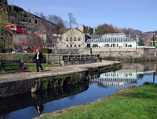
Sowerby Bridge is a market town in the Upper Calder Valley in Calderdale in West Yorkshire, England. The Calderdale Council ward population at the 2011 census was 11,703.

The River Etherow in northern England is a tributary of the River Goyt. Although now passing through South Yorkshire, Derbyshire and Greater Manchester, it historically formed the ancient county boundary between Cheshire and Derbyshire. The upper valley is known as Longdendale. The river has a watershed of approximately 30 square miles (78 km2), and the area an annual rainfall of 52.5 inches (1,330 mm).

Calderdale is a metropolitan borough of West Yorkshire, England, which had a population of 211,439. It takes its name from the River Calder, and dale, a word for valley. The name Calderdale usually refers to the borough through which the upper river flows, while the actual landform is known as the Calder Valley. Several small valleys contain tributaries of the River Calder. The main towns of the borough are Brighouse, Elland, Halifax, Hebden Bridge, Sowerby Bridge and Todmorden.
The River Wyre, in Lancashire, England, flows into the Irish Sea at Fleetwood. It is 28 miles (45 km) long and has a sheltered estuary which penetrates deep into the Fylde peninsula.

The River Colne in West Yorkshire is formed at the confluence of two brooks that originate in the Pennines close to Marsden. It flows in an easterly direction through the Colne Valley and Huddersfield towards Cooper Bridge where it flows into the River Calder.

Luddenden is a district of Calderdale 3.1 miles (5 km) west of Halifax on the Luddenden Brook in the county of West Yorkshire, England.

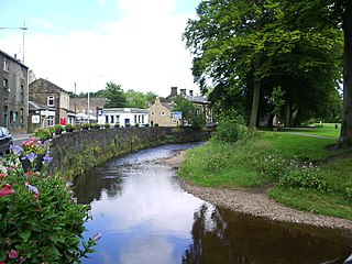
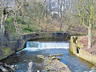
The River Ryburn is a river in West Yorkshire, England. It flows through the villages of Rishworth, Ripponden and Triangle before flowing into the River Calder at Sowerby Bridge.
Salterhebble is an area of Halifax, a town within the Metropolitan Borough of Calderdale, in West Yorkshire, England. The town falls within the Skircoat ward of Calderdale Council. Salterhebble is located where the Hebble Brook flows into the River Calder. It is on the main route into Halifax from Huddersfield and Brighouse. Salterhebble is the home of Calderdale Royal Hospital, a school, a fast food restaurant, a funeral parlour and one active pub, The Watermill. Some former pubs in the village included The Punch Bowl, The Falcon and The Stafford Arms.

Shibden Valley is to the east of Halifax, West Yorkshire, England, where the community of Shibden lies. The name of the Shibden valley comes from scepe dene meaning "sheep valley" or "Sheep Vale". The area was heavily involved in wool production but was also a site of much coal production and flagstones from Northowram, Southowram and Hipperholme areas.

The River Calder is a major tributary of the River Ribble in Lancashire, England, and is around 20 miles (32 km) in length.
Ogden in West Yorkshire, England, is a small hamlet 5.0 miles (8 km) north of Halifax. The hamlet falls within the Calderdale Ward of Illingworth and Mixenden. Its most recognisable landmarks are Ovenden Moor wind farm, which can be seen from as far as 35 miles (56 km) away on a clear day; a golf course, which offers views of the surrounding moorland; and Ogden reservoir, around which are footpaths for visitors to walk and view the local wildlife.
Pendle Water is a minor river in Lancashire, England. Rising on Pendle Hill, Pendle Water cuts a deep valley between Barley Moor and Spence Hill, where it feeds into the reservoirs of Upper and Lower Ogden.
The River Brun is a river in eastern Lancashire. It is approximately 4.5 miles (7.2 km) long and has a catchment area of 9.32 square miles (24.134 km2).

The South Pennines is a region of moorland and hill country in northern England lying towards the southern end of the Pennines. In the west it includes the Rossendale Valley and the West Pennine Moors. It is bounded by the Greater Manchester conurbation in the west and the Bowland Fells and Yorkshire Dales to the north. To the east it is fringed by the towns of West Yorkshire whilst to the south it is bounded by the Peak District. The rural South Pennine Moors constitutes both a Site of Special Scientific Interest and Special Area of Conservation.

Piethorne Brook is a watercourse in Greater Manchester. It is a tributary of the River Beal.

The Black Brook is a small river in Calderdale, West Yorkshire, England.

North Bridge is a Victorian iron and stone bridge at Halifax, West Yorkshire, in northern England. It crosses the valley of the River Hebble, connecting the town to roads to Bradford and Leeds. Replacing an earlier six arch stone bridge, it was raised to allow the subsequent construction of the Halifax and Ovenden Joint Railway beneath it, including North Bridge railway station. Opened in 1871 amid chaotic crowd scenes it carried increasingly heavy traffic until it was by-passed by the Burdock Way in 1973. It remains in use for local traffic. On the south end of the structure was a theatre, adjoining the bridge, called the Grand Theatre.

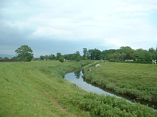
The River Calder is a river in West Yorkshire, in Northern England.

Ovenden Moor Wind Farm is a wind powered electricity generating site in England. Ovenden Moor is located north of Halifax and west of Bradford in West Yorkshire. The site was opened in 1993 with 23 turbines, but these were later removed in favour of larger turbines but with 14 fewer towers. This updated the output of the site from 9.2 MW to 22.5 MW with an expected generation lifetime of 25 years. As the turbines can be seen from some distance and the fact that they overlook the Brontë Country to the north, they have the subject of continued criticism and objections.

