Helenton Loch

Last updated

Helenton, also Ellingtone
Helenton Loch.jpg
The site of Helenton Loch in 1811
South Ayrshire UK relief location map.jpg
Red pog.svg
Helenton, also Ellingtone
LocationSymington, South Ayrshire, Scotland
Coordinates Coordinates: 55°33′1.4″N4°32′52.6″W / 55.550389°N 4.547944°W / 55.550389; -4.547944
Type Drained freshwater loch
Primary inflows Damhead and Pow Burns
Primary outflows Pow Burn
Basin  countriesScotland
Islands None
Settlements Kilmarnock

Helenton Loch was situated in a low lying area between the farms and dwellings of Helentongate, Mains, and Burnbank in the Parish of Symington, South Ayrshire, Scotland. The loch was natural, sitting in a hollow, a kettle hole, created by glaciation. The loch waters ultimately drained via the Pow Burn. Helenton Hill is a prominent landmark to the west of the old loch site. The nearby lands of Rosemount were in 1549 known as 'Goldring' and were the property of the Schaws of Sornbeg. [1]

Contents

History

The Loch

A view over the loch site and of the hamlet of Whitelees. Helenton Loch site & Whitelees.JPG
A view over the loch site and of the hamlet of Whitelees.

The loch is recorded as Ellingtone Loch on Roy's survey of 1747-55, [2] and Elintoun Loch on Blaeu's map of 1654, surveyed by Timothy Pont in the early 1600s, with an 'Elintounmur' nearby. [3] Ainslie's map of 1821 records the name 'Helenton'. [4] Aitons map of 1811 records the house and loch clearly and uses the spelling 'Halentoun'. Thomson's map of 1832 shows the loch and a mill pond serving Helenton Mill. [5]

Armstrong's Map of 1775 shows a substantial loch bordering the mansion house and wooded policies of Helentoun. [6] The 1857 OS map records only a small loch at the site. [7] The 1860s OS map shows a lane running up to the 'mill pond' or loch remnant from the Helentongate to Helenton Road in the 1860s.

The loch was drained to provide land for agriculture and a mill pond substituted. The loch remnant is now a well-drained area in the fields of Helentongate Farm. [8]

Helenton Mill

Aiton's map of 1811 showing Helenton Loch. Map of Dunduff castle & roads.jpg
Aiton's map of 1811 showing Helenton Loch.
Scotland relief location map.jpg
Red pog.svg
Symington
Previous location of Helenton Loch, South Ayrshire

The loch may have served as the head water for Ellingtone or Helenton Mill which is dated from 1583 in one source [9] and 1549 in another. [1] Two dams provided the head of water and the fall was around eleven feet powering a breast wheel and driving the two pairs of stones from Kameshill at West Kilbride. [10] Half a ton of oatmeal per hour was the maximum milling rate. [10] Provender for cattle was produced in addition to oatmeal. The mill had been built for the benefit of the tenants by the Montgomeries of Eglinton and one half of the machinery belonged to the miller. [10]

In 1583 William Wallace of Ellerslie held half the mill. [11] In 1875 Adamson records the old corn and saw mill as being ruined when he passes this way when walking from Underhill, crossing the footbridge over the Pow Burn to the mill and then continuing on to the lane to Helentongate and Symington. [12] It had closed in 1858. [10]

A Robert Calderwood, aged 68, is shown as living at Helenton Mill in 1841. He was a miller who married Margaret Wilson 1799. The couples children were Elizabeth born Symington, and siblings were born in Craigie - James, Janet, Andrew, Adam, Margaret, Jean, John, William, David, Alexander and Walter who died at Perclewan, Dalrymple in 1903. [13]

The OS maps show that a cottage once sat in the field opposite the mill entrance, most probably the miller's dwelling.

The mill pond is now an infilled area near Helenton Mote, following the closure of the mill in the late 19th century. A footpath is shown on OS maps as running down from Underhill and then crossing the Pow Burn at the old mill.

In 1884, three-quarters of a mile of the Catcraig Road was removed from Helenton Mains to Benacres, thereby truncating the route following the closure of the corn and sawmill at Helenton. [14]

Helentongate is recorded as a curling site by the Royal Caledonian Curling Club. [15]

Land ownership

In 1549 Andrew Schaw of Sornbeg is recorded as holding the lands of Goldring (Rosemount), Knockindail, and Helentoun Mains with the mill. [1]

Johne Schaw of Polkemmet next held the lands of Helentoun with its tower, mains, mill, and part of the lands of Helentoun Muir. [1] In 1582 John Schaw, son and heir, inherited the five pound lands of Helentoun. He also inherited the lands of Goldring after they had both been held by the King for a period of three years. [16]

Helenton was a part of the Lands of Symington until it came to lie within the Barony of Sanquhar-Hamilton, named for the family of Hamilton of Sanquhar. [17]

James Stewart, Earl of Arran held the lands for a time, however they passed to the Wallaces of Craigie and in 1583-4 it is recorded that William Wallace of Ellerslie held the lands of Mains of Helentoun and Bogend, together with the tower, fortalice, and manor place of Helenton, together with half of the mill. [18]

William Wallace of Helenton is recorded as having married Elizabeth Cunningham of Kilmaronok (sic) in the mid 17th century.

Etymology

The derivation of the name is far from clear as 'Helenton' does not appear as a spelling on the maps until the late 16th century, variations of the name 'Ellington' being used by cartographers prior to that date. The village of Ellington in Northumberland may derives its name from the Saxon first name 'Ella'. The Scots word 'Elenge' means remote or lonely. [19] The name 'Pow' or 'Poll' refers to a slow-moving ditch-like stream. [20]

Rev William Auld

William Aulds gravestone at Mauchline. William (Daddy) Auld's Grave, Mauchline.JPG
William Aulds gravestone at Mauchline.

The minister at Mauchline Kirk at the time of Robert Burns was the somewhat fanatical 'Auld Licht' Rev William 'Daddy' Auld, born at Auld Ellanton or Helenton Farm in 1709. He was the younger son of the Laird of Ellanton (sic), his mother being Margaret Campbell. [21] The poet and Jean Armour appeared before him for 'irregular behaviour' and he baptised their eldest son Robert as well as his sister Jean. [22]

William Aulds family held a pew within Symington church, shown on the 1797 church seating plan as 'Laird Auld'. [23] His gravestone records that he died aged 81 in the 50th year of his ministry, that his mother was Margaret Campbell and he had an only sister, Jean. He died unmarried.

A view of the Helenton Motte and Moot Hill. Helenton Mote - north-east.JPG
A view of the Helenton Motte and Moot Hill.

Helenton Motte

A motte or Moot hill was located at Helenton, once surmounted by a building and acting as the 'Justice Hill' of the barony of . [24] Smith sees it as a fort with a ditch on the south side but altered in shape due to a lade running close to one side and a road lying on the other. [25]

See also

Related Research Articles

Trabboch

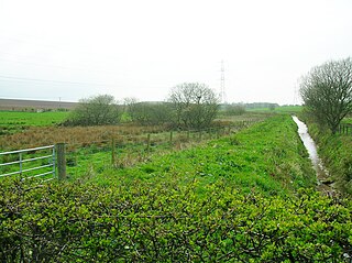
Trabboch is a hamlet in East Ayrshire, Scotland. Built as a miners village in the 1880s, it was owned and leased by Wm. Baird & Co., Ltd. and at one time had 94 dwellings. The miners rows stood, until demolition in 1969, on the Stair and Littlemill road, about two miles south of Stair, in that parish. The name is locally pronounced 'Traaboch'.

The village or hamlet of Gatehead is located in East Ayrshire, Parish of Kilmaurs, Scotland. It is one and a quarter miles from Crosshouse and one and a half miles from Kilmarnock. In the 18th and 19th centuries the locality was a busy coal mining district. The settlement runs down to the River Irvine where a ford and later a bridge was located.

The village of Springside is in North Ayrshire, Parish of Dreghorn, Scotland. It is three miles from Irvine, 1+12 miles west of Crosshouse, and four miles from Kilmarnock. In the 18th, 19th and mid-20th centuries, the locality was a highly industrialised coal mining district. The settlement is on the Garrier Burn, which forms the boundary with East Ayrshire. Springside had a population of around 1364 in 1991. The A71 now bypasses the village, 14 mile to the south.

Knockentiber is a village in East Ayrshire, Parish of Kilmaurs, Scotland. Knockentiber is two miles west-northwest of Kilmarnock and 12 mile northeast of Crosshouse. Latitude:55.6193°N Longitude:4.5455°W and grid reference NS397392. The population was 359 in 1991, however the population is much higher following the construction of several housing estates (2007). In the 18th and 19th and mid 20th centuries the locality was a highly industrialised coal mining district. The settlement is on the Carmel Burn, which runs into the River Irvine, around one mile to the south.

River Irvine River in southwest Scotland

The River Irvine is a river that flows through southwest Scotland. Its watershed is on the Lanarkshire border of Ayrshire at an altitude of 810 feet (250 m) above sea-level, near Loudoun Hill, Drumclog, and 7 miles SW by W of Strathaven. It flows 29+12 mi (47.5 km) westward, dividing the old district of Cunninghame from that of Kyle, until it reaches the sea via Irvine Harbour in the form of the Firth of Clyde, and flows into Irvine Bay by the town of Irvine. It has many tributaries, some of which form parish, district and other boundaries.

Riccarton is a village and parish in East Ayrshire, Scotland. It lies across the River Irvine from Kilmarnock, this river forming the boundary between Riccarton and Kilmarnock parishes, and also between the historical districts of Kyle and Cunningham. The name is a corruption of 'Richard's town', traditionally said to refer to Richard Wallace, the uncle of Sir William Wallace. The parish also contains the village of Hurlford.

Pow Burn

The Pow Burn is a long burn located in South Ayrshire, Scotland. The name 'Pow or 'Poll' refers to a slow-moving ditch-like stream.

Craigie Castle

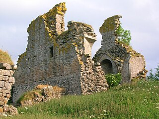
Craigie Castle, in the old Barony of Craigie, is a ruined fortification situated about 4 miles (6.4 km) southeast of Kilmarnock and 1 mile (1.6 km) southeast of Craigie village, in the Civil Parish of Craigie, South Ayrshire, Scotland. The castle is recognised as one of the earliest buildings in the county. It lies about 1.25 miles (2 km) west-south-west of Craigie church. Craigie Castle is protected as a scheduled monument.

Fail Monastery

Fail Monastery, occasionally known as Failford Abbey, had a dedication to 'Saint Mary', and was located at Fail on the bank of the Water of Fail, Parish of Tarbolton near the town of Tarbolton, South Ayrshire. Most of the remaining monastery ruins were removed in 1952. The official and rarely used title was House of the Holy Trinity of Failford or the Ministry of Failford.

Lochlea, South Ayrshire

Lochlea or Lochlie was situated in a low-lying area between the farms and dwellings of Lochlea and Lochside in the Parish of Tarbolton, South Ayrshire, Scotland. The loch was natural, sitting in a hollow created by glaciation. The loch waters ultimately drained via Fail Loch, the Mill Burn, and the Water of Fail. It is well-documented due to the presence of a crannog that was excavated and documented circa 1878, and its association with the poet Robert Burns, who lived here for several years whilst his father was the tenant. Lochlea lies 2+12 miles northeast of Tarbolton, and just over three miles northwest of Mauchline.

Loch Brown

Loch Brown, also known in Scots as Loch Broun, Broon or Broom, was situated in a kettle hole in the mid-Ayrshire clayland near Crosshands. It is nowadays (2011) visible as a surface depression in pastureland, partially flooded, situated in a low-lying area close to farms and dwellings of Skeoch, Dalsangan, Ladebrae, Lochhill, and Crosshands, mainly in the Parish of Mauchline and partly in Craigie, East Ayrshire, Scotland. Duveloch is an old name for the loch and this may derive from the Gaelic Dubh, meaning black or dark loch.

Fail Loch

Fail Loch or Faile Loch was situated in a low-lying area near the old monastery of Fail in the Parish of Tarbolton, South Ayrshire, Scotland. The old Lochlea Loch lies nearby and its waters still feed into Fail Loch via the Mill Burn.

Symington, South Ayrshire Human settlement in Scotland

Symington is a conservation village in South Ayrshire, Scotland. It is located in Symington parish, covering 0.41 square kilometres, and lies close to the A77 road from Ayr to Glasgow. Its church, built in 1160, remains one of the finest examples of a Norman church in Scotland.

Galrigs Loch (South Ayrshire)

The Galrigs Loch was a substantial freshwater loch situated in low lying area between Newfield and Dundonald in South Ayrshire, Scotland. It was drained in the early 18th century.

Clevens Loch, Ayrshire

Clevens Loch was a substantial freshwater loch situated in a low-lying area below Clevance Farm and Langholm Farm in Dundonald parish, South Ayrshire, Scotland.

Loch of Trabboch

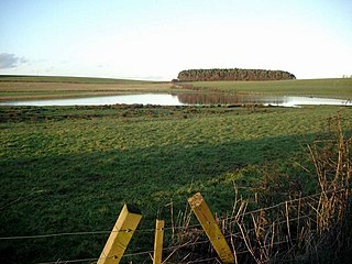
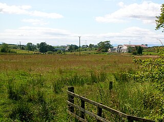
The Loch of Trabboch or Dalrympleston Loch (NS440211) was situated in a low-lying area below the old Castle of Trabboch, once held by the Boyd family in the Parish of Stair, East Ayrshire, Scotland.

Trabboch Castle is a ruined L-plan tower house in the old Barony of Trabboch, Parish of Stair, East Ayrshire, Scotland.

Polkelly Castle

Polkelly Castle, also Pokelly, was an ancient castle located near Fenwick, at NS 4568 4524, in the medieval free Barony of Polkelly, lying north of Kilmarnock, Parish of Fenwick, East Ayrshire, Scotland. The castle is recorded as Powkelly (c1747), Pockelly (c1775), Pow-Kaillie, Ponekell, Polnekel, Pollockelly, Pollockellie, Pokellie, Pothelly, Pathelly Ha' and Polkelly. The name is given circa 1564 as Powkellie when it was held by the Cunninghams of Cunninghamhead.

Shewalton House and estate Human settlement in Scotland

Shewalton House and estate were composed of the 'Lands of Shewalton' and the laird's dwelling, originally a tower castle and later a mansion house on the River Irvine in the Shewalton area, two miles from Irvine and west of Drybridge village, East Ayrshire, Dundonald Parish, Scotland. In 1883 the Boyle's estate of Shewalton was 2,358 acres in extent in Ayrshire and was worth at that time £2,708 a year.

Earlston, East Ayrshire Human settlement in Scotland

Earlston is a hamlet in Riccarton, East Ayrshire, Scotland. The habitation dates from at least the early 18th century and is near Caprington Castle and Todrigs Mill. It was for many years the site of a large sawmill and a mine pumping engine, and had sidings of the Glasgow and South-Western Railway's Fairlie Branch.

References

Notes
  1. 1 2 3 4 Paterson, Page 746
  2. Roy's Map Retrieved : 2011-02-06
  3. Blaeu's Map Retrieved : 2011-02-06
  4. Ainslie's Map Retrieved ; 2011-02-06
  5. Thomson's Map Retrieved : 2011-02-06
  6. Armstrong's Map Retrieved : 2011-02-06
  7. OS Map Retrieved : 2011-02-06
  8. Flash Earth Archived 2007-02-25 at the Wayback Machine Retrieved : 2011-02-07
  9. Old Roads of Scotland Retrieved : 2011-02-06
  10. 1 2 3 4 Wilson, Page 6
  11. Wilson, Page 7
  12. Adamson, Page 73
  13. Curious Fox Retrieved ; 2011-02-06
  14. Old Roads of Scotland Retrieved : 2011-02-06
  15. Curling Pond Sites [ permanent dead link ] Retrieved : 2011-03-18
  16. AWAA, Page 171
  17. Paterson, Page 748
  18. Paterson, Page 749
  19. Dictionary of the Scots Language Retrieved : 2011-02-07
  20. Strawhorn, Page 36
  21. McQueen, p.84
  22. Westwood, Page 54
  23. Nimmo, Page 72
  24. Paterson, Page 737
  25. Smith, Page 127
Sources
  1. Archaeological & Historical Collections relating to the counties of Ayrshire & Wigtown. Edinburgh : Ayr Wig Arch Soc. Vol. VI. 1889.
  2. Adamson, Archibald R. (1875). Rambles Round Kilmarnock. Kilmarnock : T. Stevenson.
  3. McQueen, Colib Hunter (2009). Hunters' Illustrated History of the Family, Friends and Contemporaries of Robert Burns. Messrs. Hunter McQueen and Hunter. ISBN   978-0-9559732-0-8
  4. Nimmo, John W. (2003). Symington Village, Church and People. Darvel : Alloway Publishing. ISBN   0-907526-82-9.
  5. Paterson, James (1863–66). History of the Counties of Ayr and Wigton. V. - II - Kyle. Edinburgh: J. Stillie.
  6. Smith, John (1895). Prehistoric Man in Ayrshire. London : Elliot Stock.
  7. Strawhorn, John (1994). The History of Prestwick. Edinburgh : John Donald. ISBN   0-85976-405-2
  8. Westwood, Peter (2008). Who's Who in the World of Robert Burns. Kilmarnock : Robert Burns World Federation. ISBN   978-1-899316-98-4
  9. Wilson, James Pearson (2000). The Last Miller : The Cornmills of Ayrshire. Ayrshire Monographs No.23. Ayrshire Archaeological & Natural History Society. ISBN   0-9527445-6-2.