
Helwan Governorate was one of the governorates of Egypt. It was located in Lower Egypt.
Helwan Governorate was one of the governorates of Egypt. It was located in Lower Egypt.
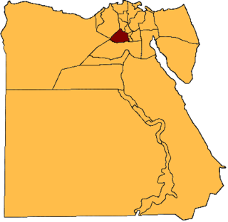
The Helwan Governorate was split from the Cairo Governorate in April 2008. It was created through a presidential decree in order to ease the burden placed on Cairo, one of Egypt's most densely populated governorates. [1] The city of Helwan became the capital of the Helwan Governorate, which encompassed most of the eastern suburbs of Cairo, notably the affluent neighbourhood of Maadi. In April 2011, Prime Minister Essam Sharaf abolished the Helwan Governorate and reincorporated its territory into the Cairo Governorate. [2]

Cairo is the capital of Egypt and the city-state Cairo Governorate, and is the country's largest city, home to 10 million people. It is also part of the largest urban agglomeration in Africa, the Arab world and the Middle East: The Greater Cairo metropolitan area, with a population of 21.9 million, is the 12th-largest in the world by population. Cairo is associated with ancient Egypt, as the Giza pyramid complex and the ancient cities of Memphis and Heliopolis are located in its geographical area. Located near the Nile Delta, the city first developed as Fustat, a settlement founded after the Muslim conquest of Egypt in 640 next to an existing ancient Roman fortress, Babylon. Under the Fatimid dynasty a new city, al-Qāhirah, was founded nearby in 969. It later superseded Fustat as the main urban centre during the Ayyubid and Mamluk periods. Cairo has long been a centre of the region's political and cultural life, and is titled "the city of a thousand minarets" for its preponderance of Islamic architecture. Cairo's historic center was awarded World Heritage Site status in 1979. Cairo is considered a World City with a "Beta +" classification according to GaWC.

Giza is the third-largest city in Egypt by area after Alexandria and Cairo; and fourth-largest city in Africa by population after Kinshasa, Lagos and Cairo. It is the capital of Giza Governorate with a total population of 9.2 million as of 2021. It is located on the west bank of the Nile, 4.9 km (3 mi) southwest of central Cairo, and is a part of the Greater Cairo metropolis. Giza lies less than 30 km (18.64 mi) north of Memphis (Men-nefer), which was the capital city of the first unified Egyptian state from the days of the first pharaoh, Narmer.

Cairo Governorate is one of the 27 governorates of Egypt. It is formed of the city of Cairo, both the national capital of Egypt and the governorate's, in addition to five satellite cities: the New Administrative Capital - set to become the seat of national government, New Cairo, Shourok, Badr, Capital Gardens, and 15th of May. These cities form almost half of the Greater Cairo metropolitan area by population.

Alexandria Governorate is one of the governorates of Egypt. The city of Alexandria was historically the capital of Egypt until the foundation of Fustat, which was later absorbed into Cairo. Today the Alexandria governorate is considered second in importance after the Cairo Governorate. It is located in the northern part of the country, directly on the Mediterranean Sea, making it one of the most important harbours in Egypt.

Egypt has a centralised system of local government officially called local administration as it is a branch of the Executive. The country is divided into twenty-seven governorates, the top tier of local administration. A governorate is administered by a governor, who is appointed by the President of Egypt and serves at the president's discretion.
Beni Suef is the capital city of the Beni Suef Governorate in Egypt. Beni Suef is the location of Beni Suef University. An important agricultural trade centre on the west bank of the Nile River, the city is located 110 km south of Cairo.
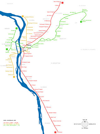
The Cairo Metro is the rapid transit system in Greater Cairo, Egypt. It was the first of the three full-fledged metro systems in Africa and the first in the Middle East to be constructed. It was opened in 1987 as Line 1 from Helwan to Ramsis square with a length of 29 kilometres (18.0 mi). As of 2013, the metro carried nearly 4 million passengers per day. As of October 2022, the Cairo Metro has 74 stations of which 4 are transfer stations, with a total length of 93.1 kilometres (57.8 mi). The system consists of three operational lines numbered 1 to 3.

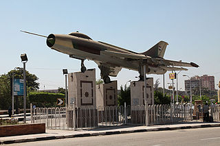
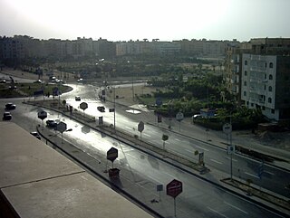
Helwan is a suburban district in the Southern Area of Cairo, Egypt. The area of Helwan witnessed prehistoric, ancient Egyptian, Roman and Muslim era activity. More recently it was designated as a city until as late as the 1960s, before it became contiguous with the city of Cairo and was incorporated as a district. For a brief period between April 2008 and April 2011 it was redesignated as a city, and served as the capital of the now defunct Helwan Governorate that was split from Cairo and Giza governorates, before being re-incorporated back into them. The kism of Helwan had a population of 521,239 in the 2017 census.
6th of October is a city in Giza Governorate, a satellite town and part of the urban area of Cairo, Egypt, 32 km outside the city. It has a population ranging between some 185,000 in the city to an estimated 500,000 inhabitants in the wider area.

Tura was the primary quarry for limestone in ancient Egypt. The site, which was known by the ancient Egyptians as Troyu or Royu, is located about halfway between modern-day Cairo and Helwan. Its ancient Egyptian name was misinterpreted by the ancient Greek geographer Strabo, who thought it meant it was inhabited by Trojans, thus the Hellenistic city was named Troia. The site is located by the modern town of Tora in the Cairo Governorate.
Egypt is divided, for the purpose of public administration, according to a three-layer hierarchy and some districts are further subdivided, creating an occasional fourth layer.
ISO 3166-2:EG is the entry for Egypt in ISO 3166-2, part of the ISO 3166 standard published by the International Organization for Standardization (ISO), which defines codes for the names of the principal subdivisions of all countries coded in ISO 3166-1.
The 6th of October Governorate was one of the governorates of Egypt. It was located in Middle Egypt, to the west of the Nile valley. It was dissolved on 14 April 2011 and was reincorporated into the Giza Governorate.

El Matareya is a district in the Eastern Area of Cairo, Egypt. The district is unrelated to the coastal town in the Dakahlia Governorate, that is also named El Matareya. The district holds the ruins of the ancient Egyptian city of Heliopolis, one of the oldest cities of ancient Egypt.

Abbassia is a neighbourhood that makes up five shiakhas in al-Wayli district in Cairo, Egypt.
Abdel Qawi Khalifa is an Egyptian engineer, academic, former governor of the Cairo province and former minister of water and wastewater utilities, a ministerial office established in August 2012.

The Islamic State – Sinai Province is a branch of the militant Islamist group Islamic State that is active in the Sinai Peninsula of Egypt.

In July 2013, at the same time as mass protests began against the 3 July coup d'état which deposed Mohamed Morsi, and in parallel with the escalation of the already ongoing jihadist insurgency in the Sinai Peninsula, pro-Muslim Brotherhood militants started violent attacks against policemen and soldiers in Central and Western Egypt. In the following months, new Islamist armed groups were created to reinstate Islamist rule in Egypt, like Soldiers of Egypt and the Popular Resistance Movement. Since 2013, violence in mainland Egypt has escalated and developed into a low-level Islamist insurgency against the Egyptian government.
Minya al-Qamh is the capital of the eponymous markaz (county) in the Nile Delta governorate of Sharqia, Egypt. The markaz is home to 11 local units, 82 villages, and 245 hamlets. In 2017, the Minya al-Qamh markaz was home to 769,333 people, while city had 87,875 residents.
El Saff is a city in the Giza Governorate, Egypt. Its population was estimated at about 59,000 people in 2018.
Coordinates: 29°51′N31°20′E / 29.850°N 31.333°E
| | This geography of Egypt article is a stub. You can help Wikipedia by expanding it. |