Henchir-El-Hatba is a village and an archaeological site in Tunisia. [1] It was a Roman Catholic diocese.
Henchir-El-Hatba is a village and an archaeological site in Tunisia. [1] It was a Roman Catholic diocese.
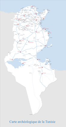
Henchir-El-Hatba also known as Ksar-el-Outibais located at 35.737815N, 8.62168E in Tunisia, 30km east of the border with Algeria [2]
Henchir-El-Hatba was settled in Roman times [3] probably during the Roman Republic. [4]
A broken inscription gives the Roman name as Fundus Ver... [5] Although the full name is not known, the town is the seat of the ancient titular see known as Verrona, it is possible that the full Roman name was Fundus Verrona.
Inscriptions from Henchir-El-Hatba show it had colonia status and may have been the site of an imperial estate . [6]
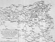
An ancient Roman Catholic titular bishopric known as the Titular Episcopal See of Verrona in the province of Numidia, was located at Henchir-El-Hatba. [7] [8]
Known Bishops

Uppenna or Upenna is a Tunisian archaeological site located on the site of the present locality of Henchir Chigarnia. The site has delivered a basilica and the remains of a fortress.
The Lex Manciana is a Roman law dealing with tenancy agreements of imperial estates in Roman North Africa.
Urusi was a civitas and ancient episcopal see of the Roman province of Africa Proconsularis in present-day Tunisia.

Henchir Mettich is a town of the Bagradas Valley region in Tunisia, c.50 km west of the ancient city of Carthage. The area around Henchir Mettich is currently a semi-arid district of mostly barren hills, some of which are currently cultivated with olive trees.
Aptuca (Africa) or Henchir Oudeka, also known as Aptucca/Aptuca, Henchir-Oudeka/Henchir-Semmech. or Udeka is a village and archaeological site in Tunisia, North Africa located at 36.409344, 8.940301.
Buruni is an ancient city of the Maghreb, in North Africa. The city has been identified with ruins at Henchir-El-Dakhla in Tunisia.

Djebba, also known as Thigibba Bure, is a town and an ancient archaeological site is located in Bājah, Tunisia. Djebba is an archaeological/prehistoric site in Tunisia located at latitude: 36°28'32.45" longitude: 9°4'53.54" in the Béja Governorate of northwestern Tunisia. The estimated terrain elevation above sea level is 355 metres located below the slopes of Djebel Gorra, 700 meters above sea level. Djebba also has a national park, which is the subject of a development project

Vallitanus or Vallis was an ancient Roman–Berber colonia in Carthage, Tunisia. The town is identified with ruins at Sidi Medien, where are located the remains of a Roman theatre, and a number of Roman inscriptions bearing witness to the town's name, and some local officials of the time can be found near the theatre.

Abbir Maius also known as Abbiritanus was a Roman and Byzantine-era civitas (city), later municipium, in the Roman province of Africa proconsularis.
Altiburus was a Roman–Berber town located in Africa Proconsularis. The town is tentatively identified with ruins at Henchir-Medeina in modern Tunisia.
Dzemda is a locality in Tunisia.
Drusiliana was a civitas (town) of Roman North Africa. Bingham called it a city of the Roman province of Mauretania Caesariensis. An inscription of Constantine the Great was found in the city ruins and it appears on the Tabula Peutingeriana The town has been tentatively identified with ruins near Khanguet-el-Kdim in northern Algeria. Located at 36.249547°N 8.907667°E. Epigraphical evidence suggest Constantine the Great undertook some works in the city in 312AD.

Henchir Bez is an archaeological site in Tunisia, located at 36° 00′ 23″ N, 9° 32 in the hills overlooking the Oued Miliane river, west of Tunis. Identified by a recently discovered inscription, it is the ruins of the Roman civitas of Vazi Sarra, which include a Christian Basilica and a Byzantine/Roman fort.
Crich El Oued, also known as Qarish el-Wadi, is a village in Tunisia, located between Bordj Toumi and Majaz al Bab in Béja Governorate east of Tunis. The village is on the Medjerda river at the confluence with the Oued el-Ahmar and the town has a mosque
Sidi-Meskin is a railway town, and archaeological site in Gouvernorat of Jendouba, Northern Tunisia. It is located in the Medjerda valley at 36.45N, 8.66E, outside of Bou Salem and is nearby to Djendouba, Mechtat el Anad and Djebel Bou Rbah. The town is located at an elevation of 430 meters above sea level, and has a mosque and railroad station.
Henchir-Aïn-Dourat, also known as Ad-Duwayrat or Henchir Durat, is a former Roman–Berber civitas and archaeological site in Tunisia. It is located at 36.767496n, 9.524142e, in the hills just north of Toukabeur and 15.3 km from Majāz al Bāb. It was an ancient Catholic diocese.
Henchir-Mâtria is an archaeological and prehistoric site in northern Tunisia. Henchir-Mâtria is at 36°31′23.4″N9°13′11.1″E, between Béja and Dougga and elevation of 407 metres. It is on the Oued el Beida River.
Gunela was an ancient Roman-Berber town and archaeological site in Bizerte Governorate, Tunisia. It was located at 37.165524n, 9.765536e, within the suburbs of Tinja, Tunisia.

Henchir-Sidi-Salah is a rural locality and archaeological site in the hinterland behind Sfax, Tunisia.
Marazanae was a Roman town of the Roman province of Byzacena during the Roman Empire and into late antiquity.