Henderson Bridge (Rhode Island)

Last updated
Henderson Bridge
Henderson Bridge Seekonk River.jpg
Henderson Bridge, Rhode Island
Coordinates 41°49′45″N71°22′40″W / 41.82925°N 71.377833°W / 41.82925; -71.377833
CarriesFour lanes of the canceled Henderson Expressway (originally)
Crosses Seekonk River
LocaleBetween Providence and East Providence, Rhode Island
Other name(s)New Red Bridge
Owner Rhode Island Department of Transportation
Maintained by Rhode Island Department of Transportation
ID number 6000
Characteristics
Material Steel
Total length
  • 624.8 metres (2,050 ft) (bridge)
  • 1 mile (bridge and completed portion of expressway) [1]
Width29.6 metres (97 ft)
Clearance below 12.8 metres (42 ft)
History
DesignerGeorge Henderson
Opened
  • 1969 (1969) (old bridge)
  • 2023 (new bridge)
Closed
  • 2023 (old bridge)
Replaces
  • Swing bridge called Red Bridge built in 1895 (old 1969 bridge)
  • 1969 bridge (new 2023 bridge)
Statistics
TollNone
Location
Henderson Bridge (Rhode Island)
References
National Bridge Inventory

The Henderson Bridge (also locally and informally known as the New Red Bridge) is a bridge in Rhode Island which spans the Seekonk River, and connects the East Side neighborhood of Providence with the Watchemoket and Phillipsdale neighborhoods of East Providence. After a major reconstruction, the bridge reopened to automobile traffic in phases from November 16 to 20, 2023, [2] A new cycle path opened on November 27. [3] A few weeks later, it was used as a detour during the emergency closure of the westbound half of the parallel Washington Bridge.

Contents

History

The bridge was opened in 1969 to replace an old bridge to the south, known as the Red Bridge, which connected the ends of Waterman Street on either side of the Seekonk River. The bridge was named after its designer, George Henderson (an engineer), of Rumford, Rhode Island.

Previous bridges in the area

This is the sixth bridge to have been built in this part of the Seekonk River. The first was a wooden bridge built by Moses Brown in 1793 called the Central Bridge, which connected the respective ends of Waterman Avenue. The same year, Brown's brother John built the first Washington Bridge at a ferry landing point one mile south, connecting India Point and Watchemoket Square. The second and third bridges were built as replacements and were destroyed in 1807 and 1815, respectively. [4] A swing bridge was built in 1872, which was replaced by a sturdier bridge of the same type in 1895. [5]

Henderson Expressway

From the late 1950s to the mid-1970s, the Henderson Bridge was planned to be part of an expressway, envisioned by the Rhode Island Department of Public Works (RIDPW; now the Rhode Island Department of Transportation, or RIDOT) and the Massachusetts Department of Public Works (MassDPW; now the Massachusetts Department of Transportation, or MassDOT), that would carry a partially relocated and partially upgraded US 44 from Providence to Plymouth, MA. [1] It would have extended from the Interstate 195 interchange with Gano Street east across the west shore of the Seekonk River, over the new bridge, and through East Providence to the existing surface US 44 boulevard (Taunton Avenue) near the Massachusetts border. [1] MassDPW would upgrade the existing US 44 from the Rhode Island border to Taunton and then relocate US 44 to a new dedicated freeway section from Taunton to Plymouth. [1] The bridge and the Rhode Island portion of the expressway were named after then-former RIDPW chief engineer George H. Henderson. [1]

At what would have been the final western terminus of the incomplete expressway at I-195/US 6/U. S. Route 1A#Rhode Island (US 6 and US 1A were re-routed to overlap with I-195 at some point), US 44 would have presumably used a short section of I-195 (a shortened part of its current overlap along I-195) to exit at South Main Street. During the upgrade/construction of I-195/US 6 to full expressway and Interstate status, a trumpet interchange was built at Gano Street to create enough capacity for the never-completed western extension of the Henderson Expressway. [1] These ramps were partially removed, reconfigured, and partially replaced in the mid-to-late 2000s as part of the reconstruction/partial replacement of the Washington Bridge (which carries I-195, US 6, US 44, and US 1A between Providence and East Providence) and the construction of the Iway relocation of I-195 in Providence from I-95 to Gano Street and the Washington Bridge. [1]

From 1961 until the mid-1970s, the Providence City Plan Commission proposed an alternate route for the expressway in Providence, arguing to extend it west through the East Side neighborhood using an out-of-service railroad tunnel (originally built as part of the Providence, Warren, and Bristol Railroad) to Downtown Providence to end at I-95 and US 6/Route 10. [1]

Between 1967 and 1969, the first (and only) section to be completed was built, consisting of the bridge itself, its western approach (tying into a partially built interchange with the one-way pair of South Angell Street and Waterman Street), and an eastern approach including two partially-built interchanges at Massasoit Avenue and Broadway in East Providence. [1] Until 2023, eastbound signage near and at the eastern end of the expressway at Broadway referred to Broadway as being part of Route 152. (RI 152 has its southern terminus to the northwest of this interchange at Route 114 and US 1A; more recently, RIDOT officials have reported not knowing why these signs refer to RI 152 as extending down Broadway and cannot find any surviving records discussing a potential extension of RI 152 down Broadway past the Henderson Expressway towards Taunton Avenue and Waterman Avenue (US 44), I-195/US 6/US 1A, and RI 103. However, they believe there could have been a proposal for (what local roadgeek and historian Steve Anderson refers to as) "part of a larger plan to provide a marked parallel route for US 1A / RI 114 south to I-195 and Veterans [Memorial] Parkway." In their correspondence with Anderson RIDOT referred to the 1969 signs referring to a RI 152 extension as "relics of mid-20th century highway planning processes." [1] ) To the east of Broadway, RIDOT purchased the right-of-way (but did not construct) for the never-built eastern extension to Taunton Avenue (US 44) and the East Providence, RI/Seekonk, MA line and state border. However, RIDOT did clear the land to the freeway's proposed end at US 44 (Taunton Avenue). [1] An interchange with Route 114/US 1A (Pawtucket Avenue) was planned to be built as part of this section, before ending at Taunton Avenue just west of the state line and never-built Massachusetts portion of the expressway. [1]

The rebuild in the 2020s freed 25 acres of land for redevelopment, and also reduced the bridge width to serve local traffic rather than the never-built expressway. [6]

Under the Bridge

Woods and trails under and around the East Providence side of the bridge are often used by dirt-bikers for recreational use. River Road exists beneath the Providence side of the bridge, and provides access to Blackstone Park and Trails (a breach in the fence-line on the westbound side of the bridge near the "South Angell Street" signage provides quick access into the park); (a short path on the eastbound side of the bridge before the ascent onto the bridge provides access to River Road).

Repair work

On April 17, 2008, it was reported that the bridge required $50 million worth of repairs, but the state only had $3.3 million to allocate. Some problems noted are cracks in the concrete pier caps & rusting steel beams. RIDOT chief engineer Kazem Farhoumand has stated that steel reinforcements can be bolted onto the steel beams to make them "good for another 5 or 10 years." [7] The Henderson was one of 25 bridges to receive "minor repairs" in late 2015, after a "hurry-up" program of bridge inspections in August 2015. [8]

2021 reconstruction

New bridge under construction in May 2023 Henderson Bridge - new bridge under construction.jpg
New bridge under construction in May 2023

Transit and bike advocates have asked for years that the bridge be replaced by a more multimodal structure. [9] In February 2019 it was announced that the existing four lane bridge will be replaced with a new two lane bridge with pedestrian and bike lanes. [10]

Work began on reconstruction in January 2021. The project was expected to cost $84.4 million, with $54.5 million coming from a federal spending bill and the rest from the state. [11] The bridge remained open to traffic, with one half of the bridge closed and rebuilt at a time. [11]

The new bridge features three traffic lanes (instead of the current six),[ contradictory ] and a separated bicycle/pedestrian infrastructure with connections to existing on-street bicycle networks. [12] Current interchanges will be converted to roundabouts. [12] While the bridge will include bike/pedestrian infrastructure, the interchange design on the east side of the Seekonk River has faced criticism for a lack of any way for pedestrians or cyclists to safely cross traffic lanes. [13]

See also

Related Research Articles

<span class="mw-page-title-main">Interstate 195 (Rhode Island–Massachusetts)</span> Highway in Rhode Island and Massachusetts

Interstate 195 (I-195) is an auxiliary Interstate Highway running a combined 44.55 miles (71.70 km) in the US states of Rhode Island and Massachusetts. It travels from a junction with I-95 in Providence, Rhode Island, east to a junction with I-495 and Massachusetts Route 25 in Wareham, Massachusetts. It runs east–west and passes through the cities of Fall River, Massachusetts, and New Bedford, Massachusetts. The portion of I-195 in East Providence is also known as the East Providence Expressway.

<span class="mw-page-title-main">Rhode Island Route 3</span> State highway in Rhode Island, US

Route 3 is a 30.1-mile-long (48.4 km) state highway in the U.S. state of Rhode Island. Route 3 serves as a local alternative to Interstate 95 (I-95) as it parallels I-95 for almost its entire length. Route 3 in West Warwick was the site of The Station nightclub fire.

<span class="mw-page-title-main">Rhode Island Route 10</span> State highway in Providence County, Rhode Island, US

Route 10 is a numbered state highway connector in the U.S. state of Rhode Island, traveling along the Huntington Expressway, the first freeway in the state. It connects Route 12 on the Cranston–Providence city line with Interstate 95 (I-95), U.S. Route 6 (US 6), and Memorial Boulevard in downtown Providence, passing just east of the Olneyville area of Providence. It provides an alternate route to I-95 south of downtown, and connects it with the US 6 freeway west from Olneyville towards I-295 and Connecticut.

<span class="mw-page-title-main">Route 15 (Rhode Island–Massachusetts)</span> Highway in Rhode Island and Massachusetts

Route 15 is a state highway in the U.S. states of Rhode Island and Massachusetts. The highway runs 8.3 miles (13.4 km) from U.S. Route 44 in North Providence, Rhode Island east through Pawtucket to the Massachusetts state line, where the highway continues for 0.23 miles (0.37 km) to Route 152 in Seekonk.

<span class="mw-page-title-main">Rhode Island Route 37</span> State highway in Rhode Island, US

Route 37 is a state highway running 3.47 miles (5.58 km) in Providence County and Kent County, Rhode Island, United States. A freeway for its entire length, it serves the cities of Cranston and Warwick and is also a major east–west freeway in the Providence metropolitan area, linking T. F. Green Airport with Interstate 295. The western terminus of Route 37 is an at-grade intersection with Natick Avenue in Cranston. The freeway has numbered interchanges with I-295, Rhode Island Route 2, Pontiac Avenue, and I-95 before terminating at a trumpet interchange with U.S. Route 1 in Warwick.

<span class="mw-page-title-main">Route 78 (Rhode Island–Connecticut)</span> Highway in Connecticut and Rhode Island

Route 78, also known as the Westerly Bypass, is a two-lane freeway between Pawcatuck, Connecticut, to Westerly, Rhode Island. The route is about 4.6 miles (7.4 km) long and begins at Connecticut Route 2 in Stonington, crossing into Rhode Island at the Pawcatuck River, where it continues as a freeway to U.S. Route 1 in Westerly. The route was constructed in 1979, after a sixteen-year delay. The designation was to become part of the Orient Point–Watch Hill Bridge, but this plan was later dropped. The route was given the memorial name of Veterans Way in 2004.

<span class="mw-page-title-main">Rhode Island Route 99</span> State highway in Providence County, Rhode Island, US

Route 99, also known as the Woonsocket Industrial Highway, is a numbered state highway running 2.9 miles (4.7 km) in Providence County, Rhode Island, United States. The route is a nominally north–south limited-access freeway for its entire length. Route 99 serves Manville and the Highland Industrial Park, providing freeway access to the city of Woonsocket from Rhode Island Route 146, which bypasses the city. The southern terminus of Route 99 is at a partial interchange with Route 146 in Lincoln. The freeway has one interchange in Manville, a village in Lincoln, before terminating at an at-grade intersection with Rhode Island Route 122 in Woonsocket.

<span class="mw-page-title-main">Rhode Island Route 114</span> State highway in Rhode Island, US

Route 114 is a 45.7-mile-long (73.5 km) numbered state highway in the U.S. state of Rhode Island. It connects the city of Newport to the city of Woonsocket. Route 114 was a major north–south artery for its entire length until the arrival of the Interstate Highway System. It is still a major commercial corridor on Aquidneck Island and in northern Rhode Island.

<span class="mw-page-title-main">U.S. Route 1A</span> Highways in United States

U.S. Route 1A (US 1A) is the name of several highways found in the United States.

<span class="mw-page-title-main">Rhode Island Route 146</span> State highway in Providence County, Rhode Island, US

Route 146 is a 16.24-mile (26.14 km) north-south expressway in the U.S. state of Rhode Island, maintained by the Rhode Island Department of Transportation (RIDOT). Spanning approximately 16 miles (26 km) along a northwest–southeast axis, it links the cities of Providence, Woonsocket, and Worcester, Massachusetts.

<span class="mw-page-title-main">Massachusetts Route 140</span> Highway in Massachusetts

Route 140 is a 107.76-mile-long (173.42 km) north—south state highway which passes through Bristol, Norfolk and Worcester counties in Massachusetts. The highway follows a southeast-northwest trajectory, running from U.S. Route 6 in New Bedford just north of Buzzards Bay northwest to an intersection with Route 12 in Winchendon, a few miles south of the border with New Hampshire.

<span class="mw-page-title-main">Interstate 95 in Rhode Island</span> Section of Interstate 95

Interstate 95 (I-95) is the main north–south Interstate Highway on the East Coast of the United States, running generally southwest–northeast through the US state of Rhode Island. It runs from the border with Connecticut near Westerly, through Warwick and Providence, and to the Massachusetts state line in Pawtucket. It has two auxiliary routes, both of which enter Massachusetts—I-195, a spur from Providence east to Cape Cod, and I-295, a western bypass of the Providence metropolitan area.

<span class="mw-page-title-main">Washington Bridge (Providence, Rhode Island)</span> Bridge in Between Providence and East Providence, Rhode Island

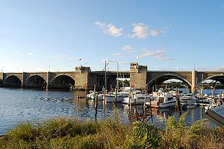
The Washington Bridge is a series of three bridges carrying Interstate 195, US Route 6, US Route 44, and U.S. Route 1A over the Seekonk River connecting India Point in Providence to Watchemoket Square in East Providence, Rhode Island. The historic portion of the bridge dating to 1930 serves as the pedestrian crossing, and bike link to the East Bay Bike Path. The pedestrian span is also a part of the Washington-Rochambeau National Historic Trail. As of December 11, 2023, the westbound bridge is closed to all but emergency vehicles due to critical safety issues.

<span class="mw-page-title-main">U.S. Route 6 in Rhode Island</span> Section of U.S. Highway in Rhode Island, United States

U.S. Route 6 (US 6) is a major east–west road in the U.S. state of Rhode Island. Nationally, the route continues west to Bishop, California, and east to Provincetown, Massachusetts. In western Rhode Island, it forms part of one of several routes between Hartford, Connecticut, and Providence and was planned to be replaced by Interstate 84 (I-84). The part of I-84 that was built, from I-295 to Olneyville, is now part of US 6. At Olneyville, US 6 joins Route 10 and heads east toward Downtown, Providence, where it turns south on I-95 and east on I-195. US 6 splits from I-195 in East Providence, crossing into Massachusetts on Warren Avenue. The whole route of US 6 is a state highway maintained by the Rhode Island Department of Transportation (RIDOT).

<span class="mw-page-title-main">Ten Mile River (Seekonk River tributary)</span> River in Massachusetts and Rhode Island, United States

The Ten Mile River is a river within the U.S. states of Massachusetts and Rhode Island. It flows approximately 22 miles (35 km) and drains a watershed of 54 square miles (140 km2).

<span class="mw-page-title-main">U.S. Route 6 in Massachusetts</span>

U.S. Route 6 (US 6) in Massachusetts is a 117.952-mile-long (189.825 km) portion of the cross-country route connecting Providence, Rhode Island, to Fall River, New Bedford, and Cape Cod. In the Fall River and New Bedford areas, US 6 parallels Interstate 195 (I-195). On Cape Cod, US 6 is a highway interconnecting the towns of the area. The freeway section in this area is also known as the Mid-Cape Highway. The highway is also alternatively signed as the "Grand Army of the Republic Highway".

The Runnins River is a river in the U.S. states of Massachusetts and Rhode Island. It flows approximately 14 km (9 mi).

<span class="mw-page-title-main">Route 152 (Rhode Island–Massachusetts)</span> Highway in Rhode Island and Massachusetts

Route 152 is a state highway in the U.S. states of Rhode Island and Massachusetts. The highway begins at U.S. Route 1A and Route 114 in East Providence, Rhode Island. After crossing into Massachusetts, Route 152 runs 14.8821 miles (23.9504 km) through Seekonk, Attleboro, and North Attleboro to US 1 in Plainville.

<span class="mw-page-title-main">East Bay Bike Path</span> Multi-use trail in Rhode Island

The East Bay Bike Path is a 14.5-mile (23.3 km) paved rail trail in Rhode Island. The path begins in Providence and India Point Park, crosses the Seekonk River via the George Redman Linear Park and Washington Bridge and continues southeast to Bristol along the shoreline of Narragansett Bay. The path passes through the city of East Providence, the hamlet of Riverside, and the towns of Barrington and Warren. It is part of the East Coast Greenway, a 3,000-mile system of trails connecting the Canada–US border in Maine to Key West. and provides access to Haines State Park, Brickyard Pond (Barrington), and Colt State Park. It is used annually by 1.1 million people.

<span class="mw-page-title-main">U.S. Route 44</span> Highway in the United States

U.S. Route 44 (US 44) is an east–west United States Numbered Highway that runs for 237 miles (381 km) through four states in the Northeastern United States. The western terminus is at US 209 and New York State Route 55 (NY 55) in Kerhonkson, New York, a hamlet in the Hudson Valley region. The eastern terminus is at Route 3A in Plymouth, Massachusetts.

References

  1. 1 2 3 4 5 6 7 8 9 10 11 12 Anderson, Steve. "Henderson Expressway". BostonRoads.com. Retrieved January 27, 2024.
  2. Traffic shifts to new Henderson Bridge
  3. New Henderson Bridge to gradually open starting Thursday night
  4. Conforti, Joseph (1976). Our Heritage: A History of East Providence. White Plains, New York: Monarch Publishing, Inc. pp. 56–57.
  5. "Providence's Golden Age: 1868-1899". Providence City Archives. City of Providence, RI. Archived from the original on 24 September 2015. Retrieved 3 September 2019.
  6. Redesigned and rebuilt Henderson Bridge fully opens
  7. Bridge Repair Article
  8. Smith, Gregory (31 August 2015). "R.I. bridges: Inspections result in major work on 2 spans, repairs on 25 others". The Providence Journal. Retrieved 20 January 2016.
  9. "Transport Providence: East Providence in a Pretzel". Archived from the original on 2014-03-12.
  10. Machado, Steph (25 February 2019). "Henderson Bridge will be replaced using $54 million in federal aid". WPRI Eyewitness News. Retrieved 26 February 2019.
  11. 1 2 "Travel Advisory: Travel Lane Reduction and Lane Shift Start January 22 for the Henderson Bridge Project in East Providence and Providence". RIDOT. State of Rhode Island. Retrieved 24 January 2021.
  12. 1 2 "Henderson Bridge No. 600 & Henderson Expressway". RIDOT. State of Rhode Island. Retrieved 24 January 2021.
  13. "Henderson Bridge Virtual Town Hall Meeting Q&A" (PDF). RIDOT. State of Rhode Island. Retrieved 20 December 2022.