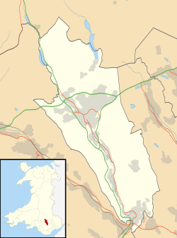
Heolgerrig

Last updated

Heolgerrig
Heolgerrig Geograph-478881-by-Bonelli.jpg
The village of Heolgerrig with the A470 trunk road in the foreground and Mynydd Aberdâr beyond
Merthyr Tydfil UK location map.svg
Red pog.svg
Heolgerrig
Location within Merthyr Tydfil
OS grid reference SO034067
Principal area
Ceremonial county
Country Wales
Sovereign state United Kingdom
Post town Merthyr Tydfil
Postcode district CF48
Dialling code 01685
Police South Wales
Fire South Wales
Ambulance Welsh
UK Parliament
Senedd Cymru – Welsh Parliament
List of places
UK
Wales
Merthyr Tydfil
51°44′45″N3°24′10″W / 51.7459°N 3.4028°W / 51.7459; -3.4028 Coordinates: 51°44′45″N3°24′10″W / 51.7459°N 3.4028°W / 51.7459; -3.4028

Heolgerrig (Welsh for "stony road"; formerly "Pen-yr-Heolgerrig") is a small village in Merthyr Tydfil County Borough, Wales. It is part of the community of Cyfarthfa. [1]

Contents

Calfaria Welsh chapel in Heolgerrig, Merthyr Tydfil. Calfaria, Heolgerrig (Merthyr Tudful).JPG
Calfaria Welsh chapel in Heolgerrig, Merthyr Tydfil.

It lies just west of Merthyr Tydfil, and is separated from it by the main A470 trunk road.

Village amenities include the Heolgerrig primary school, The Red Lion pub, The Heolgerrig Social Club, three chapels and a post office and small convenience store.

People from Heolgerrig

Notes

  1. Davies, John; Jenkins, Nigel; Menna, Baines; Lynch, Peredur I., eds. (2008). The Welsh Academy Encyclopaedia of Wales. Cardiff: University of Wales Press. p. 554. ISBN   978-0-7083-1953-6.


Related Research Articles

Merthyr Tydfil Human settlement in Wales

Merthyr Tydfil is the main town in Merthyr Tydfil County Borough and administered by Merthyr Tydfil County Borough Council. It is about 23 miles (37 km) north of Cardiff, Wales. Often known as Merthyr, the town is said to be named after Tydfil, a daughter of King Brychan of Brycheiniog. According to her legend she was slain at Merthyr by pagans about 480 CE; the place was subsequently named in her honour. Although merthyr generally means "martyr" in modern Welsh, the meaning here is closer to the Latin martyrium: a place of worship built over relics of a martyr. Similar examples from south Wales are Merthyr Cynog, Merthyr Dyfan and Merthyr Mawr.

Abercynon Human settlement in Wales

Abercynon, is both a village and a community in the Cynon Valley within the unitary authority of Rhondda Cynon Taf, Wales. The community comprises the village and the districts of Carnetown and Grovers Field to the south, Navigation Park to the east, and Glancynon to the north.

Hirwaun Human settlement in Wales

Hirwaun is a village and community at the north end of the Cynon Valley in the County Borough of Rhondda Cynon Taf, South Wales. It is 4 miles (6 km) NW of the town of Aberdare, and comes under the Aberdare post town. At the 2001 census, Hirwaun had a population of 4,851. increasing at the 2011 census to 4,990. The village is on the Heads of the Valleys Road and at the southern edge of the Brecon Beacons National Park.

Bedlinog is a small village located in The Taff Bargoed valley 10 km north of Pontypridd, 10 km north west of Caerphilly and 10 km south east of Merthyr Tydfil in south-east Wales. It is currently in the south of Merthyr Tydfil County Borough, but until 1974 was part of Gelligaer Urban District Council in the county of Glamorgan.

Quakers Yard railway station Railway station in Merthyr Tydfil, Wales

Quakers Yard railway station serves the village of Edwardsville in the community of Treharris, Merthyr Tydfil, Wales. It is located on the Merthyr Tydfil branch of the Merthyr Line. Passenger services are provided by Transport for Wales.

Penywaun Human settlement in Wales

Penywaun is a community, electoral ward and north-western suburb of Aberdare in the Cynon Valley within the county borough of Rhondda Cynon Taf, Wales. At the 2011 census, the population of the ward was registered as 3,063.

Merthyr Vale Human settlement in Wales

Merthyr Vale is a linear village and community in the Welsh county borough of Merthyr Tydfil. Lying on the A4054 road it is on the east bank of the River Taff.

Treharris Human settlement in Wales

Treharris is a small town and community in the Taff Bargoed Valley in the south of Merthyr Tydfil County Borough, South Wales. It is located about 0.6 miles (1.0 km) west of Trelewis, from which it is separated by the Taff Bargoed river, and 0.9 miles (1.4 km) from Nelson in Caerphilly county borough and has a population of 6,356 from the 2011 Census. As a community, Treharris includes the villages of Quakers Yard and Edwardsville. Due to steepness and narrowness of both the Taff and Taff Bargoed valleys at Treharris several notable bridges and viaducts have been built in the area.

Eddie Thomas (boxer) Welsh boxer and manager

Edward Thomas MBE was a Welsh professional boxer and boxing manager. He was born in Merthyr Tydfil. After a highly successful amateur boxing career, he turned professional in 1946. He won the Welsh welterweight title in 1948 and the British welterweight title in 1949, becoming the first Welsh fighter to hold the belt for more than 30 years. He won the European welterweight title in 1951, retaining it for only four months. He held the British Empire title for a period in the same year.

Penydarren Park

Penydarren Park is a sports stadium in Merthyr Tydfil, Wales, that is the present home ground of Merthyr Town F.C.. Historically used for varying sports, it has been the home to two professional football teams, Merthyr Town and Merthyr Tydfil F.C.. It has a capacity of 4,500.

This article is about the particular significance of the year 1862 to Wales and its people.

Michael Gustavius Payne

Michael Gustavius Payne is a Welsh figurative painter. He paints primarily in oils and is influenced by mythological themes within a contemporary context. During his early exhibiting career he was known as Michael Payne, before he began using his full name. Since late 2012 he has dropped his first name and now uses the shorter Gustavius Payne.

Mike Jenkins (poet)

Mike Jenkins is a Welsh poet and fiction writer in English. He is also the father of the Plaid Cymru politician Bethan Sayed and of the journalist Ciaran Jenkins.

Cefn-coed-y-cymmer

Cefn-coed-y-cymmer is a small community on the northwestern edge of Merthyr Tydfil County Borough in Wales. It is situated in the neck of land between the rivers Taf Fawr and Taf Fechan at their confluence. The village lies within the community of Vaynor. Immediately to the north of the village is the hill of Cefn Cil Sanws on the southern slopes of which is Merthyr Tydfil Golf Club. The village is bounded both to the north and the west by the Brecon Beacons National Park.

Cyfarthfa Human settlement in Wales

Cyfarthfa is a community and electoral ward in the west of the town of Merthyr Tydfil in Merthyr Tydfil County Borough, Wales.

Park, Merthyr Tydfil Human settlement in Wales

Park is a community and electoral ward of the county borough of Merthyr Tydfil, in Wales.

Jamie Bevan

Gareth Jamie Bevan is a Welsh language campaigner from Merthyr Tydfil, Wales and a prominent member of Cymdeithas yr Iaith Gymraeg. Bevan refused to pay fines and costs to Merthyr Tydfil Magistrate's Court for breaking into Conservative Party offices in north Cardiff the day before a visit from David Cameron in a demonstration against cuts to S4C.

Merthyr Tydfil County Borough

Merthyr Tydfil County Borough has been one of the 22 unitary authorities in Wales since 1 April 1996. Merthyr Tydfil County Borough today has a population of 60,183. It is located in the historic county of Glamorgan and takes its name from Merthyr Tydfil town. The County Borough consists of the northern part of the Taff Valley and the smaller neighbouring Taff Bargoed Valley. It borders the counties of Rhondda Cynon Taf to the west, Caerphilly county borough to the east, and Powys to the north.

Heolgerrig Halt railway station served the village of Heolgerrig, in the historical county of Glamorgan, Wales, from 1937 to 1961 on the Brecon and Merthyr Tydfil Junction Railway.