Herbertsdale

Last updated
Herbertsdale
South Africa Western Cape location map.svg
Red pog.svg
Herbertsdale
South Africa adm location map.svg
Red pog.svg
Herbertsdale
Coordinates: 34°01′S21°46′E / 34.017°S 21.767°E / -34.017; 21.767 Coordinates: 34°01′S21°46′E / 34.017°S 21.767°E / -34.017; 21.767
Country South Africa
Province Western Cape
District Garden Route
Municipality Mossel Bay
Area
[1]
  Total2.87 km2 (1.11 sq mi)
Population
(2011) [1]
  Total666
  Density230/km2 (600/sq mi)
Racial makeup (2011)
[1]
   Black African 8.3%
   Coloured 77.0%
   Indian/Asian 1.2%
   White 12.6%
  Other0.9%
First languages (2011)
[1]
   Afrikaans 95.9%
   English 2.3%
  Other1.9%
Time zone UTC+2 (SAST)
PO box
6505
Area code 044

Herbertsdale is a settlement in Garden Route District Municipality in the Western Cape province of South Africa.

Garden Route District Municipality District municipality in Western Cape, South Africa

The Garden Route District Municipality is a district municipality located in the Western Cape Province of South Africa. Its municipality code is DC4.

Western Cape Province of South Africa on the south-western coast

The Western Cape is a province of South Africa, situated on the south-western coast of the country. It is the fourth largest of the nine provinces with an area of 129,449 square kilometres (49,981 sq mi), and the third most populous, with an estimated 6.6 million inhabitants in 2018. About two-thirds of these inhabitants live in the metropolitan area of Cape Town, which is also the provincial capital. The Western Cape was created in 1994 from part of the former Cape Province.

South Africa Republic in the southernmost part of Africa

South Africa, officially the Republic of South Africa (RSA), is the southernmost country in Africa. It is bounded to the south by 2,798 kilometres (1,739 mi) of coastline of Southern Africa stretching along the South Atlantic and Indian Oceans; to the north by the neighbouring countries of Namibia, Botswana, and Zimbabwe; and to the east and northeast by Mozambique and Eswatini (Swaziland); and it surrounds the enclaved country of Lesotho. South Africa is the largest country in Southern Africa and the 25th-largest country in the world by land area and, with over 57 million people, is the world's 24th-most populous nation. It is the southernmost country on the mainland of the Old World or the Eastern Hemisphere. About 80 percent of South Africans are of Sub-Saharan African ancestry, divided among a variety of ethnic groups speaking different African languages, nine of which have official status. The remaining population consists of Africa's largest communities of European (White), Asian (Indian), and multiracial (Coloured) ancestry.

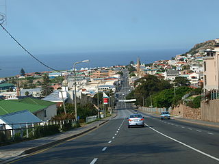
Village east of the Gourits River, in the Langtou Valley, 56 km north-west of Mossel Bay. It was established in 1865 on the farm Hemelrood and named after James Benton Herbert, who owned part of this farm. [2]

Gourits River river in the Western Cape, South Africa

Gourits River, sometimes spelled 'Gouritz River', is situated in the Western Cape, South Africa.

Mossel Bay Place in Western Cape, South Africa

Mossel Bay is a harbour town of about 130,000 people on the Southern Cape of South Africa. It is an important tourism and farming region of the Western Cape Province. Mossel Bay lies 400 kilometres east of the country's seat of parliament, Cape Town, and 400 km west of Port Elizabeth, the largest city in the Eastern Cape Province. The older parts of the town occupy the north-facing side of the Cape St Blaize Peninsula, whilst the newer suburbs straddle the Peninsula and have spread eastwards along the sandy shore of the Bay.

Related Research Articles

Centurion, Gauteng Place in Gauteng, South Africa

Centurion is an area with 236,580 (2011 Census) inhabitants in Gauteng Province of South Africa, located between Pretoria and Midrand (Johannesburg). Formerly an independent municipality, with its own town council, it has formed part of the City of Tshwane Metropolitan Municipality since 2000. Its heart is located at the intersection of the N1 and N14 freeways. The R21 also passes through Centurion.

Kempton Park, Gauteng Place in Gauteng, South Africa

Kempton Park is a main place of Ekurhuleni in the Gauteng province, South Africa. Kempton Park has been part of the City of Ekurhuleni Metropolitan Municipality since 2000. Kempton Park is located on the western city limits of Ekurhuleni and shares its administrative boundaries with Johannesburg, South Africa's largest city. It is situated south of Tembisa, one of the largest townships in South Africa which is also integrated into Ekurhuleni. The name of the city is sometimes written as "Kemptonpark" in Afrikaans.

Delmas, Mpumalanga Place in Mpumalanga, South Africa

Delmas is a small maize farming town situated east of Johannesburg in Mpumalanga, South Africa. The town is located some 19 km north-east of Springs and 73 km south-east of Pretoria.

Bela-Bela Place in Limpopo, South Africa

Bela-Bela is a town in the Limpopo Province of South Africa. Deriving its name from the geothermic hot springs around which the town was built, it was called Warmbaths, until 2002.

Zeerust Place in North West, South Africa

Zeerust is a commercial town situated in Ngaka Modiri Molema district North West Province, South Africa. It lies in the Marico valley, approximately 240 kilometres northwest of Johannesburg. It lies on the N4, the main road link between South Africa and Botswana. There are large cattle ranches in the area, as well as wheat, maize, tobacco and citrus fruit farms. There are also fluorite and chromite mines in the vicinity. Tourism is also a developing industry.

Mossel Bay Local Municipality Local municipality in Western Cape, South Africa

Mossel Bay Municipality is a municipality located in the Western Cape Province of South Africa. As of 2011 the population was 89,430.

Koster, North West Place in North West, South Africa

Koster is a small farming town situated on the watershed between the Orange and Limpopo Rivers in North West Province of South Africa.

The R327 is a Regional Route in South Africa. Its northern origin is from the R62 near Ladismith. From there it winds generally south-east. It goes over Cloete's Pass before reaching Herbertsdale. On the other side of the town it crosses the Du Plessis Pass. It then reaches its south-eastern terminus at the N2 near Mossel Bay.

Robertsham Place in Gauteng, South Africa

Robertsham is a suburb of Johannesburg, South Africa. It is situated in the city's southern suburbs just south of the CBD. It is located in Region F of the City of Johannesburg Metropolitan Municipality.

Parkmore Place in Gauteng, South Africa

Parkmore is a suburb of Johannesburg, South Africa. It is located in Region B of the City of Johannesburg Metropolitan Municipality.

Berario Place in Gauteng, South Africa

Berario is a suburb of Johannesburg, in the South African province of Gauteng. It is located in Region 4. It is located just below Northcliff Hill and close to Cresta Shopping Centre, one of the biggest malls in South Africa.

Braamfontein Place in Gauteng, South Africa

Braamfontein is a central suburb of Johannesburg, in South Africa, seat of the Constitutional Court of South Africa and some of South Africa's major corporations such as Liberty Holdings Limited, JD Group, Sappi, Bidvest Bank and Hollard. Situated due north of the city centre, Braamfontein is the fourth-largest office node in the city of Johannesburg containing many multi-storied buildings representing various architectural styles including Art Deco and Brutalist. Numerous office buildings have and are in the process of being converted to residential apartments. The offices of the Johannesburg City Council and the University of the Witwatersrand are situated in Braamfontein. The Nelson Mandela Bridge is a landmark that connects Braamfontein to the city centre, traversing South Africa's most extensive passenger train marshalling yard. Jan Smuts Avenue and Empire Road are two major road thoroughfares that run through the suburb.

Greenside, Gauteng Place in Gauteng, South Africa

Greenside is a suburb of Johannesburg, South Africa. Greenside borders on the suburbs Emmarentia, Parkview, Parkhurst and Victory Park.

Strydenburg Place in Northern Cape, South Africa

Strydenburg is a town in the east of the Northern Cape province in South Africa. Seventy-seven km north of Britstown, it was laid out by the Dutch Reformed Church on the farm Roodepan in 1892. It also lies on the N12, which separates the actual town from its township.

Cloetes Pass

Cloete's Pass is situated in the Western Cape province of South Africa, on the Regional road R327 between Van Wyksdorp and Herbertsdale. The Langeberg mountain range separates the southern Cape coast from the Little Karoo. One of the little-known passes is the Cloete's pass, named after the Cloete family who owned the farm there. It is a gravel pass that features many flowering plants and ruins of old toll houses and blockhouses built by the British during the Anglo-Boer war.

Du Plassis Pass is situated in the Western Cape province of South Africa, on the Regional road R327 between Mossel Bay and Herbertsdale.

Bothasig A suburban area of the Northern Suburbs of Cape Town

Bothasig also known as 'The Sig' is a suburban area of the City of Cape Town in Western Cape, South Africa. It is located north of Edgemead and east of Milnerton. It is located approximately 15 km north-east of the Cape Town city centre.

Willowmore Place in Eastern Cape, South Africa

Willowmore is a town in Sarah Baartman District Municipality in the Eastern Cape province of South Africa.

Waterval Estate, Randburg Place in Gauteng, South Africa

Waterval Estate is a suburb of Johannesburg, South Africa.It is located in Region B of the City of Johannesburg Metropolitan Municipality, is close to Randburg's centre.

References

  1. 1 2 3 4 "Main Place Herbertsdale". Census 2011.
  2. "Dictionary of Southern African Place Names (Public Domain)". Human Science Research Council. p. 206.