
Fynbos is a small belt of natural shrubland or heathland vegetation located in the Western Cape and Eastern Cape provinces of South Africa. This area is predominantly coastal and mountainous, with a Mediterranean climate and rainy winters. The fynbos ecoregion is within the Mediterranean forests, woodlands, and scrub biome. In fields related to biogeography, fynbos is known for its exceptional degree of biodiversity and endemism, consisting of about 80% species of the Cape floral kingdom, where nearly 6,000 of them are endemic. This land continues to face severe human-caused threats, but due to the many economic uses of the fynbos, conservation efforts are being made to help restore it.

The Karoo is a semi-desert natural region of South Africa. No exact definition of what constitutes the Karoo is available, so its extent is also not precisely defined. The Karoo is partly defined by its topography, geology and climate, and above all, its low rainfall, arid air, cloudless skies, and extremes of heat and cold. The Karoo also hosted a well-preserved ecosystem hundreds of million years ago which is now represented by many fossils.

George Municipality is a local municipality within the Garden Route District Municipality, in the Western Cape province of South Africa. As of 2011, the population is 193,672. Its municipality code is WC044.

Oudtshoorn Municipality is a local municipality within the Garden Route District Municipality, in the Western Cape province of South Africa. As of 2022, the population was 138,257.

Breede Valley Municipality is a local municipality located within the Cape Winelands District Municipality, in the Western Cape province of South Africa. As of 2007, it had a population of 166,825. Its municipality code is WC025.

Cederberg Municipality is a local municipality which governs an area of the Western Cape province of South Africa stretching from the Cederberg mountains through the middle valley of the Olifants River to the Atlantic coast. It includes the towns of Clanwilliam, Citrusdal and Lamberts Bay, and the surrounding villages and farms. As of 2011 it had a population of 49,768. It is located within the West Coast District Municipality and its municipality code is WC012.

Kannaland Municipality is a local municipality located within the Garden Route District Municipality, in the Western Cape province of South Africa. The municipal area is situated in the western part of the Little Karoo and includes the towns of Ladismith, Calitzdorp and Zoar. As of 2022, it has a population of 31,986. Its municipality code is WC041.

Laingsburg Municipality is a local municipality located in the Western Cape province of South Africa. As of 2022, the population is 11,366. Its municipality code is WC051.

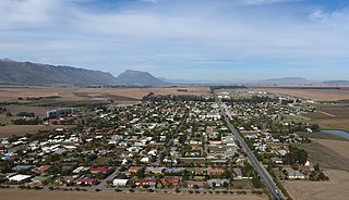
Oudtshoorn is a town in the Western Cape province of South Africa, located between the Swartberg mountains to the north and the Outeniqua Mountains to the south. Dubbed the "ostrich capital of the world", Oudtshoorn is known for its ostrich-feather booms, during 1865–1870 and 1900–1914. With approximately 60,000 inhabitants, it is the largest town in the Klein Karoo region. The town's economy is primarily reliant on the ostrich farming and tourism industries. Oudtshoorn is home to the world's largest ostrich population, with a number of specialised ostrich breeding farms, such as the Safari Show Farm and the Highgate Ostrich Show Farm, as stated by Pierre D. Toit.

The Swartberg mountains are a mountain range in the Western Cape province of South Africa. It is composed of two main mountain chains running roughly east–west along the northern edge of the semi-arid Little Karoo. To the north of the range lies the other large semi-arid area in South Africa, the Great Karoo. Most of the Swartberg Mountains are above 2000 m high, making them the tallest mountains in the Western Cape. It is also one of the longest, spanning some 230 km from south of Laingsburg in the west to between Willowmore and Uniondale in the east. Geologically, these mountains are part of the Cape Fold Belt.

The N12 is a national route in South Africa which runs from George through Beaufort West, Kimberley, Klerksdorp and Johannesburg to eMalahleni.

De Rust is a small village at the gateway to the Klein Karoo, South Africa. The name is Dutch and literally translates to "The Rest", referring to the town's original purpose of being a resting place for settlers en route through the challenging terrain of a nearby Swartberg gorge.
Olifants River is a river in the Klein Karoo area of the Western Cape, South Africa.

Calitzdorp is a town on the Western side of the Little or Klein Karoo in the Western Cape Province of South Africa and lies on South Africa's Route 62.
Porterville is a town in the Western Cape province of South Africa.
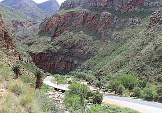
Meiringspoort is a South African mountain pass on the N12 national road, where it crosses the Swartberg mountain range.

Marco Cianfanelli is a South African artist who has been involved in a wide range of projects involving art, architecture and public spaces. Cianfanelli combines computer-generated, data-driven applications with human, expressive, gestural acts to create tension in his work. Cianfanelli is one of a handful of South African artists whose work successfully spans the public and domestic sphere. He began his career painting landscapes and continues to be concerned with romanticized space and that which is marginalized through the very act of romanticizing. Cianfanelli's slick, pared-down, iconographic recent works are intricately linked with the complexity of loving South Africa.
Prince Albert Road is a village located in Laingsburg Local Municipality, Western Cape.
The Gouritz Cluster Biosphere Reserve is located in the Western Cape of South Africa. It is the 7th and largest of South Africa’s biosphere reserves; divided into four connected sectors ranging from sea level to 2,240 metres. The area is the only place in the world where three recognised biodiversity hotspots converge. The site is characterised by high endemism of plant species and threatened invertebrates including seven endemic species of the enigmatic beetle genus Colophon and 14 butterfly species. It provides a migratory route for large mammals such as the leopard and serves as a nursery for marine species.
The Kammanassie Mountains are a mountain range in the Western Cape, South Africa. The highest peak is Mannetjiesberg at 1,955 metres above sea level and the mountain range is one of the prominent east-west trending ranges composing the southern branch of the Cape Fold Belt.


