
Hertford Heath is a village and civil parish near the county town of Hertford in Hertfordshire, England. The population at the 2011 Census was 2,672.

Patmore Heath is a 7.6 hectare biological Site of Special Scientific Interest in East Hertfordshire, 2 kilometres north-east of Albury, Hertfordshire. The site was notified in 1985 under the Wildlife and Countryside Act 1981. Patmore Heath is home to a large amount of dry grass, as well as marshy-areas. Much turf throughout the SSSI is dominated by Deschampsia, as well as occurrences of Anthoxanthum odoratum.

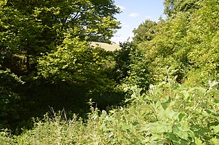
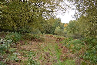
Wormley-Hoddesdonpark Wood North is a 143.9 hectare woodland area in Hertfordshire which has been designated as a biological site of Special Scientific Interest. The site is listed as Grade 1 in A Nature Conservation Review, and is also designated a Special Area of Conservation. It is in Hoddesdon in the borough of Broxbourne, but part of the site is in East Hertfordshire.

Herts and Middlesex Wildlife Trust manages over 40 nature reserves covering nearly 810 hectares north of London, in Hertfordshire and the historic county of Middlesex, part of which is divided between the London boroughs of Barnet, Enfield, Harrow and Hillingdon. It has over 21,000 members, and is one of 46 Wildlife Trusts across the UK. It is a Registered Charity, with its Registered Office in St Albans, and had an income in the year to 31 March 2014 of over £1.5 million.

Rye Meads is a 58.5 hectare biological Site of Special Scientific Interest (SSSI) in Rye House, Hoddesdon, Hertfordshire. It is one of series of wetlands and reservoirs situated along the River Lea, to the north-east of London. It is part of the Lea Valley Ramsar site and a Special Protection Area.

Old Park Wood is a 16.7-hectare (41-acre) Site of Special Scientific Interest in Harefield in the London Borough of Hillingdon. The south-east part is an 8-hectare (20-acre) nature reserve owned and managed by the Hertfordshire and Middlesex Wildlife Trust.

Frogmore Meadows is a 4.6 hectare biological Site of Special Scientific Interest in Hertfordshire and Buckinghamshire, north of the village of Chenies. It consists of two meadows in the Chilterns Area of Outstanding Natural Beauty, next to the River Chess, one of which is a Hertfordshire and Middlesex Wildlife Trust nature reserve. The planning authorities are Three Rivers District Council, Dacorum Borough Council and Chiltern District Council.

Hunsdon Mead is a 34 hectare biological Site of Special Scientific Interest (SSSI) west of Harlow and east of Roydon in Essex. The site is partly in Essex and partly in Hertfordshire, and it is jointly owned and managed by the Essex Wildlife Trust and the Herts and Middlesex Wildlife Trust. The SSSI also includes part of the neighbouring Roydon Mead. The planning authorities are East Hertfordshire District Council and Epping Forest District Council. Hunsdon Mead is registered common land.

Sawbridgeworth Marsh is a 6.3 hectare biological Site of Special Scientific Interest (SSSI) near Sawbridgeworth in Hertfordshire, apart from a small area in the north which is in Essex. It is managed by the Essex Wildlife Trust. The planning authorities are East Hertfordshire District Council and Uttlesford District Council.
Waterford Heath is a 35.2 hectare Local Nature Reserve in Waterford in Hertfordshire, England. It is owned by Lafarge Tarmac and managed by the Herts and Middlesex Wildlife Trust together with East Hertfordshire District Council and Lafarge.

Balls Wood is a 58.5 hectare nature reserve managed by the Herts and Middlesex Wildlife Trust in Hertford Heath in East Hertfordshire. The wood was purchased by the Trust from the Forestry Commission.
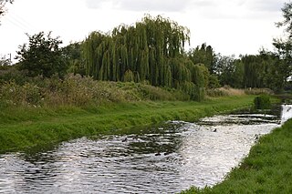
Thorley Wash or Thorley Flood Pound is a 17.3-hectare biological Site of Special Scientific Interest in Thorley, south of Bishop's Stortford in Hertfordshire. It was formerly a flood pound for the Stort Navigation, which was decommissioned in 2004 and converted to a more natural state. It was purchased by the Herts and Middlesex Wildlife Trust from the Environment Agency in 2011.

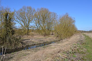
Tewinbury is a 7.5 hectare biological Site of Special Scientific Interest near Tewin in Hertfordshire. The local planning authority is East Hertfordshire District Council, and the site is managed by the Herts and Middlesex Wildlife Trust

Fox Covert is a 2.9 hectare nature reserve near Royston in North Hertfordshire. It is owned and managed by the Herts and Middlesex Wildlife Trust.
Hill End Pit is a 0.7 hectare a nature reserve on the site of a former chalk pit, in St Paul's Walden in North Hertfordshire. It was formerly managed by the Herts and Middlesex Wildlife Trust (HMWT). In February 2016 HMWT announced that three sites, Barkway Chalk Pit, Hill End Pit and Pryor's Wood, which HMWT managed on behalf of their owner, North Hertfordshire District Council, were to return to Council management as the Trust was no longer able to meet the cost. It has the largest colony of Azeca goodalli snails in Hertfordshire. Plants include viper's bugloss, cowslip and marjoram, there are butterflies such as common blue and gatekeeper, and many birds including woodpeckers.
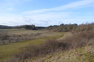
King's Meads is a nature reserve between the towns of Hertford and Ware in Hertfordshire. It is managed by the Herts and Middlesex Wildlife Trust, and with an area of 96 hectares it is the largest of the Trust's reserves. The site has been registered by the Trust as Common land, but the registration for some areas was disallowed due to objections.
Danemead is a 5.6-hectare nature reserve west of Hoddesdon in Hertfordshire, managed by the Herts and Middlesex Wildlife Trust. It is part of the Wormley-Hoddesdonpark Wood North Site of Special Scientific Interest.

