Hesper Mews

Last updated

Hesper Mews
Hesper Mews London October 2022 24.jpg
Houses in Hesper Mews
Kensington and Chelsea London UK location map.svg
Red pog.svg
Hesper Mews within the borough of Kensington and Chelsea
Part of Gunter Estate
TypeMews street
LocationEarl's Court, London
Postal codeSW5
Coordinates 51°29′30″N0°11′24″W / 51.4916°N 0.1901°W / 51.4916; -0.1901
Construction
Construction start1884-85

Hesper Mews is a mews street in the Earl's Court district of London, England. It runs between Bramham Gardens and Collingham Gardens and was laid-out in 1884-85 as part of the Gunter Estate, developed in the nineteenth century by James Gunter and his descendants.

Contents

Houses in the Mews are much smaller than in the higher-class streets adjacent and were used as accommodation for servants and stabling for horses. Later they were home to drivers and their vehicles, and from the mid-twentieth century were increasingly occupied by middle and upper-class families.

Origins

Hesper Mews on an Ordnance Survey map of 1913 Hesper Mews on Ordnance Survey map of 1913.png
Hesper Mews on an Ordnance Survey map of 1913

Hesper Mews was laid out in 1884-85 as part of the Gunter Estate which was developed by James Gunter and his descendants in the nineteenth century. [1] The origin of its name is unknown. [2]

The Mews are to the east of Earls Court Road and immediately to the south of Barkston Gardens which was built by the Gunters on the site of the former Earl's Court House. [1] The area was largely rural before the Gunter family began to develop it and the Mews lie on farmland formerly known as Four Acre Court Field and part of Great Courtfield. [1]

They are in the Earl's Court district of London, England, in the Royal Borough of Kensington and Chelsea, and run between Bramham Gardens and Collingham Gardens and largely parallel to Bramham Gardens. There are three closes on the north side. [3]

Character

The Survey of London write that mews were of "considerable importance" to the Gunter Estate, with Hesper Mews the last mews to be laid out, in 1884–85, "the biggest and finest" and "on generous lines". [1] It is one of the few mews on the Estate that is accessed from the higher status streets around it through a normal street entrance rather than through an archway. [1] Nonetheless, the role of mews houses as accommodation for servants, particularly coachmen, with stabling on the ground floor for their employer's horses, [4] [5] is evident from the street plan with the houses in Barkston Gardens and Bramham Gardens, on to which the mews back, being much larger than those in Hesper Mews.

The British Architect commented in 1886, with reference to houses in Collingham Gardens, with which the Mews were also associated, that the stables in Hesper Mews were "quite out of sight" of Collingham Gardens, [6] reflecting the need at the time for rich and poor to have "proximate but separate lives". [4] As the horse gave way to the motor car, the coachmen of London's mews were replaced by, or found new employment as, chauffeurs and drivers with the ground floor used as garages for their vehicles, [7] but, in the mid and later twentieth century, as the original leases ended and London's mews became gentrified, mews houses were increasingly occupied by middle and upper-class families. [8]

Notable residents

Number 26 seen in 2022 Hesper Mews London October 2022 14.jpg
Number 26 seen in 2022

Notable former residents include:

See also

Related Research Articles

<span class="mw-page-title-main">William Kent</span> English architect, landscape architect, painter and furniture designer of the early 18th century

William Kent was an English architect, landscape architect, painter and furniture designer of the early 18th century. He began his career as a painter, and became Principal Painter in Ordinary or court painter, but his real talent was for design in various media.

Earl's Court is a district of Kensington in the Royal Borough of Kensington and Chelsea in West London, bordering the rail tracks of the West London line and District line that separate it from the ancient borough of Fulham to the west, the sub-districts of South Kensington to the east, Chelsea to the south and Kensington to the northeast. It lent its name to the now defunct eponymous pleasure grounds opened in 1887 followed by the pre–World War II Earls Court Exhibition Centre, as one of the country's largest indoor arenas and a popular concert venue, until its closure in 2014.

<span class="mw-page-title-main">Royal Mews</span> Grade I listed transport museum in City of Westminster, United Kingdom

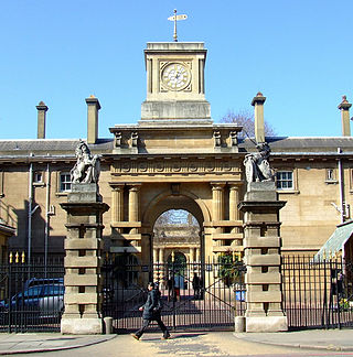
The Royal Mews is a mews, or collection of equestrian stables, of the British royal family. In London these stables and stable-hands' quarters have occupied two main sites in turn, being located at first on the north side of Charing Cross, and then within the grounds of Buckingham Palace.

<span class="mw-page-title-main">Berkeley Square</span> Town square in the West End of London, England

Berkeley Square is a garden square in the West End of London. It is one of the best known of the many squares in London, located in Mayfair in the City of Westminster. It was laid out in the mid 18th century by the architect William Kent, and originally extended further south. The garden's very large London Plane trees are among the oldest in central London, planted in 1789.

<span class="mw-page-title-main">Mews</span> Type of housing above stables

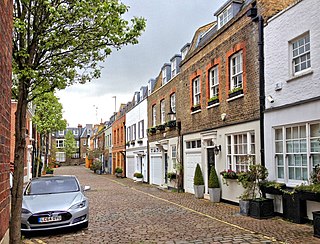
A mews is a row or courtyard of stables and carriage houses with living quarters above them, built behind large city houses before motor vehicles replaced horses in the early twentieth century. Mews are usually located in desirable residential areas, having been built to cater for the horses, coachmen and stable-servants of prosperous residents.

<span class="mw-page-title-main">Gloucester Road, London</span>

Gloucester Road is a street in the Royal Borough of Kensington and Chelsea, London. It runs north–south between Kensington Gardens and Old Brompton Road.

<span class="mw-page-title-main">Bramham, West Yorkshire</span> Village in West Yorkshire, England

Bramham is a village in the civil parish of Bramham cum Oglethorpe in the City of Leeds metropolitan borough, West Yorkshire, England.

West Kensington, formerly North End, is an area in the ancient parish of Fulham, in the London Borough of Hammersmith and Fulham, England, 3.4 miles (5.5 km) west of Charing Cross. It covers most of the London postal area of W14, including the area around Barons Court tube station, and is defined as the area between Lillie Road and Hammersmith Road to the west, Fulham Palace Road to the south, Hammersmith to the north and West Brompton and Earl's Court to the east. The area is bisected by the major London artery the A4, locally known as the Talgarth Road. Its main local thoroughfare is the North End Road.

<span class="mw-page-title-main">West Brompton</span> Human settlement in England

West Brompton is an area of west London, England, that straddles the boundary between the London Borough of Hammersmith and Fulham and Royal Borough of Kensington and Chelsea. The centuries-old boundary was traced by Counter's Creek, now lost beneath the West London Line railway.

<span class="mw-page-title-main">Robert Gunter</span> British Army officer

Sir Robert Gunter, 1st Baronet was a British Army officer, property developer and Conservative Party politician who sat in the House of Commons from 1885 to 1905.

<span class="mw-page-title-main">Townhouse (Great Britain)</span> Town or city residence of a member of the British nobility or gentry

In British usage, the term townhouse originally referred to the opulent town or city residence of a member of the nobility or gentry, as opposed to their country seat, generally known as a country house or, colloquially, for the larger ones, stately home. The grandest of the London townhouses were stand-alone buildings, but many were terraced buildings.

<span class="mw-page-title-main">Weymouth Street</span> Street in the City of Westminster, London, England

Weymouth Street lies in the Marylebone district of the City of Westminster and connects Marylebone High Street with Great Portland Street. The area was developed in the late 18th century by Henrietta Cavendish Holles and her husband Edward Harley, 2nd Earl of Oxford. This part of Marylebone originally belonged to the Manor of Tyburn which existed at the time of the Domesday Book (1086).

<span class="mw-page-title-main">Devonshire Street</span> Street in City of Westminster, London, England

Devonshire Street is a street in the City of Westminster, London. Adjoining Harley Street, it is known for the number of medical establishments it contains.

<span class="mw-page-title-main">Devonshire Close</span> Street in London

Devonshire Close, originally known as Devonshire Mews East, is a mews street in the City of Westminster, London, accessed from Devonshire Street. The Close is on a distinctive H plan with a middle downwards leg. It dates from the 1770s and originally contained a timber yard, stables, and accommodation for domestic servants who worked in the larger houses surrounding it. Access was limited to the north side in order to divert traffic from the grander north–south streets around it. The Close was gentrified in the 20th century and its buildings converted to mews houses which, like other mews in London, have become desirable in the modern era because they are quiet and have little traffic. The Close is now part of the Howard de Walden Estate.

<span class="mw-page-title-main">Cornwall Gardens</span>

Cornwall Gardens is a long narrow garden square in South Kensington, London, England.

This is a list of the etymology of street names in the London district of Marylebone. The following utilises the generally accepted boundaries of Marylebone viz. Marylebone Road to the north, Great Portland Street to the east, Marble Arch and Oxford Street to the south and Edgware Road to the west.

<span class="mw-page-title-main">Kynance Mews</span> Mews street in South Kensington, London, England

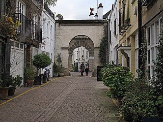
Kynance Mews is a mews street in South Kensington district of the Royal Borough of Kensington and Chelsea in London, SW7. The mews consists of 33 residential properties on a setted road that passes from Gloucester Road on the east, before being bisected by Launceston Place, with the western end of the mews ending in a cul-de-sac. The entrances to the mews pass through three arches, each listed Grade II on the National Heritage List for England. The arches were built c. 1860 to a design by Thomas Cundy III.

<span class="mw-page-title-main">Cadogan Lane</span> Street in Belgravia, London

Cadogan Lane, originally Little Cadogan Place, is a street in London's Belgravia which runs between Pont Street in the north, and a junction with Cadogan Place and D'Oyley Street in the south. It is one of the streets in the area named after the Earls of Cadogan that began to be developed in 1777. The lane was laid-out by 1799 but had few buildings until the twentieth century. Today it is mostly made up of small mews houses which back onto the larger houses in Cadogan Place, and Chesham Place and Chesham Street, between which Cadogan Lane runs.

<span class="mw-page-title-main">Collingham Gardens</span> Garden square in Kensington and Chelsea, London

Collingham Gardens is a garden square in the Royal Borough of Kensington and Chelsea in London. Built between 1881 and 1888, the buildings on either side of the garden were designed by Ernest George and Peto, a firm that grafted Northern European urban motifs onto plainer Queen Anne style stock.

References

  1. 1 2 3 4 5 "The Gunter estate". Survey of London. Retrieved 25 October 2022.
  2. Bebbington, Gillian. (1972) London Street Names. London: B. T. Batsford. p. 172. ISBN   0713401400
  3. Ordnance Survey map of London. Southampton, 1916, sheet VIII.4.
  4. 1 2 Uncover London: How Very A-Mewsing. Bruno Diaz, Londnr, 7 November 2018. Retrieved 7 November 2022.
  5. "Devonshire, Weymouth and New Cavendish Streets" in South-East Marylebone, Survey of London Vols. 51 & 52, London, 2017.
  6. "Houses in Collingham Gardens", The British Architect, 12 March 1886, pp. 245-246.
  7. Historic England. "41-42 and 43 Hay's Mews (1474784)". National Heritage List for England . Retrieved 9 November 2022.
  8. Glass, Ruth. (1964) London: Aspects of change. London: MacGibbon & Kee. p. xviii-xix.
  9. Creative Canada: A biographical dictionary of twentieth-century creative and performing artists volume 1. University of Toronto Press, 1971. ISBN   9781442637832
  10. "D’Oyly-Hughes, Captain Guy." Who's Who 2022, online edition, Oxford University Press, Oxford. Retrieved 1 November 2022.
  11. Catalogue of the Sport in Art Exhibition Together with List of Awards in the International Competition 15 July to 14 August. London, 1948. p. 48.
  12. The British Imperial Calendar and Civil Service List. H. M. Stationery Office, London, 1952. p. 733.
  13. "The Membership and Programs of the IGY Participating Committees", Annals of the International Geophysical Year , Vol. IX (1959), p. 245.
  14. People of Today, Debrett's Peerage Limited, London, 1995. p. 577. ISBN   1870520246

Commons-logo.svg Media related to Hesper Mews at Wikimedia Commons