Hetland, South Dakota

Last updated

Hetland, South Dakota
Kingsbury County South Dakota Incorporated and Unincorporated areas Hetland Highlighted.svg
Location in Kingsbury County and the state of South Dakota
Coordinates: 44°22′36″N97°14′05″W / 44.37667°N 97.23472°W / 44.37667; -97.23472
Country United States
State South Dakota
County Kingsbury
Founded1880 [1]
Area
[2]
  Total0.11 sq mi (0.30 km2)
  Land0.11 sq mi (0.30 km2)
  Water0.00 sq mi (0.00 km2)
Elevation
[3]
1,732 ft (528 m)
Population
 (2020) [4]
  Total20
  Density175.44/sq mi (67.56/km2)
Time zone UTC-6 (Central (CST))
  Summer (DST) UTC-5 (CDT)
ZIP codes
57212, 57244
Area code 605
FIPS code 46-28460 [5]
GNIS feature ID1267421 [3]

Hetland is a town in Kingsbury County, South Dakota, United States. The population was 46 at the 2010 census.

Contents

History

A post office called Hetland was established in 1888, and remained in operation until it was discontinued in 1997. [6] The town was named for John Hetland, a pioneer settler who was murdered while traveling from Sioux Falls to his homestead near the present site of Hetland. [7] [8]

Geography

According to the United States Census Bureau, the town has a total area of 0.11 square miles (0.28 km2), all land. [9]

Demographics

Historical population
CensusPop.Note
1900 162
1910 22337.7%
1920 24811.2%
1930 2500.8%
1940 199−20.4%
1950 123−38.2%
1960 107−13.0%
1970 81−24.3%
1980 66−18.5%
1990 53−19.7%
2000 43−18.9%
2010 467.0%
2020 20−56.5%
U.S. Decennial Census [10] [4]

2010 census

As of the census [11] of 2010, there were 46 people, 17 households, and 11 families residing in the town. The population density was 418.2 inhabitants per square mile (161.5/km2). There were 24 housing units at an average density of 218.2 per square mile (84.2/km2). The racial makeup of the town was 100.0% White.

There were 17 households, of which 23.5% had children under the age of 18 living with them, 41.2% were married couples living together, 11.8% had a female householder with no husband present, 11.8% had a male householder with no wife present, and 35.3% were non-families. 17.6% of all households were made up of individuals, and 5.9% had someone living alone who was 65 years of age or older. The average household size was 2.71 and the average family size was 2.91.

The median age in the town was 35 years. 34.8% of residents were under the age of 18; 4.3% were between the ages of 18 and 24; 19.5% were from 25 to 44; 30.4% were from 45 to 64; and 10.9% were 65 years of age or older. The gender makeup of the town was 56.5% male and 43.5% female.

2000 census

As of the census [5] of 2000, there were 43 people, 18 households, and 10 families residing in the town. The population density was 374.7 inhabitants per square mile (144.7/km2). There were 21 housing units at an average density of 183.0 per square mile (70.7/km2). The racial makeup of the town was 100.00% White.

There were 18 households, out of which 27.8% had children under the age of 18 living with them, 44.4% were married couples living together, 11.1% had a female householder with no husband present, and 44.4% were non-families. 38.9% of all households were made up of individuals, and 16.7% had someone living alone who was 65 years of age or older. The average household size was 2.39 and the average family size was 3.30.

In the town, the population was spread out, with 27.9% under the age of 18, 20.9% from 18 to 24, 23.3% from 25 to 44, 16.3% from 45 to 64, and 11.6% who were 65 years of age or older. The median age was 28 years. For every 100 females, there were 104.8 males. For every 100 females age 18 and over, there were 106.7 males.

The median income for a household in the town was $32,500, and the median income for a family was $32,813. Males had a median income of $21,667 versus $13,750 for females. The per capita income for the town was $9,239. None of the population or families were below the poverty line.

Related Research Articles

<span class="mw-page-title-main">Wolsey, South Dakota</span> Town in South Dakota, United States

Wolsey is a town in Beadle County, South Dakota, United States. The population was 459 at the 2020 census.

<span class="mw-page-title-main">Stratford, South Dakota</span> Town in South Dakota, United States

Stratford is a town in southern Brown County, South Dakota, United States. The population was 57 at the 2020 census.

<span class="mw-page-title-main">Westport, South Dakota</span> Town in South Dakota, United States

Westport is a town in western Brown County, South Dakota, United States. The population was 88 at the 2020 census.

<span class="mw-page-title-main">Fort Thompson, South Dakota</span> CDP in South Dakota, United States

Fort Thompson is a census-designated place (CDP) in Buffalo County, South Dakota, United States. The population was 1,282 at the 2010 census, making it the largest settlement on the Crow Creek Reservation.

<span class="mw-page-title-main">Mound City, South Dakota</span> Town in South Dakota, United States

Mound City is a town in and the county seat of Campbell County, South Dakota, United States. The population was 69 at the 2020 census.

<span class="mw-page-title-main">Ravinia, South Dakota</span> Town in South Dakota, United States

Ravinia is a town in Charles Mix County, South Dakota, United States. The population was 71 at the 2020 census.

<span class="mw-page-title-main">Bradley, South Dakota</span> Town in South Dakota, United States

Bradley is a town in Clark County, South Dakota, United States. The population was 65 at the 2020 census.

<span class="mw-page-title-main">Florence, South Dakota</span> Town in South Dakota, United States

Florence is a town in northwestern Codington County, South Dakota, United States. It is part of the Watertown, South Dakota Micropolitan Statistical Area. The population was 337 at the 2020 census.

<span class="mw-page-title-main">Fairburn, South Dakota</span> Town in South Dakota, United States

Fairburn is a town in Custer County, South Dakota, United States. The population was 60 at the 2020 census.

<span class="mw-page-title-main">Ethan, South Dakota</span> Town in South Dakota, United States

Ethan is a town in Davison County, South Dakota, United States. It is part of the Mitchell, South Dakota Micropolitan Statistical Area. The population was 365 at the 2020 census. Ethan is located 10 miles south of Mitchell.

<span class="mw-page-title-main">Revillo, South Dakota</span> Town in South Dakota, United States

Revillo is a town in southeastern Grant County, South Dakota, United States. The population was 99 at the 2020 census.

<span class="mw-page-title-main">Hudson, South Dakota</span> Town in South Dakota, United States

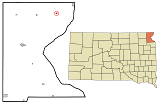
Hudson is a town in Lincoln County, South Dakota, United States. The population was 311 at the 2020 census. It is the easternmost community in South Dakota.

<span class="mw-page-title-main">Lake City, South Dakota</span> Town in South Dakota, United States

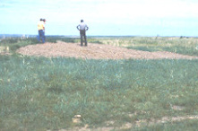
Lake City is a town in Marshall County, South Dakota, United States. The population was 45 at the 2020 census. Fort Sisseton Historic State Park, whose fort is listed on the National Register of Historic Places, is located nearby.

<span class="mw-page-title-main">Langford, South Dakota</span> Town in South Dakota, United States

Langford is a town in Marshall County, South Dakota, United States. The population was 283 at the 2020 census.

<span class="mw-page-title-main">Crooks, South Dakota</span> City in South Dakota, United States

Crooks is a city in Minnehaha County, South Dakota, United States and is a suburb of Sioux Falls. The population was 1,362 at the 2020 census. Crooks was named New Hope until 1904. The town's present name honors W. A. Crooks, a local politician.

<span class="mw-page-title-main">Corona, South Dakota</span> Town in South Dakota, United States

Corona is a town in Roberts County, South Dakota, United States. The population was 69 at the 2020 census.

<span class="mw-page-title-main">Peever, South Dakota</span> Town in South Dakota, United States

Peever is a town in Roberts County, South Dakota, United States. The population was 180 at the 2020 census.

<span class="mw-page-title-main">Rosholt, South Dakota</span> Town in South Dakota, United States

Rosholt is a town in Roberts County, South Dakota, United States. The population was 379 at the 2020 census.

<span class="mw-page-title-main">Tulare, South Dakota</span> Town in South Dakota, United States

Tulare is a town in Spink County, South Dakota, United States. The population was 211 at the 2020 census.

<span class="mw-page-title-main">Davis, South Dakota</span> Town in South Dakota, United States

Davis is a town in Turner County, South Dakota, United States. The population was 54 at the 2020 census.

References

  1. "SD Towns" (PDF). South Dakota State Historical Society. Archived from the original (PDF) on February 10, 2010. Retrieved February 13, 2010.
  2. "ArcGIS REST Services Directory". United States Census Bureau. Retrieved October 15, 2022.
  3. 1 2 U.S. Geological Survey Geographic Names Information System: Hetland, South Dakota
  4. 1 2 "Census Population API". United States Census Bureau. Retrieved October 15, 2022.
  5. 1 2 "U.S. Census website". United States Census Bureau . Retrieved January 31, 2008.
  6. "Kingsbury County". Jim Forte Postal History. Retrieved March 19, 2015.
  7. Chicago and North Western Railway Company (1908). A History of the Origin of the Place Names Connected with the Chicago & North Western and Chicago, St. Paul, Minneapolis & Omaha Railways. p. 83.
  8. Federal Writers' Project (1940). South Dakota place-names, v.1-3. University of South Dakota. p. 41.
  9. "US Gazetteer files 2010". United States Census Bureau. Archived from the original on January 25, 2012. Retrieved June 21, 2012.
  10. "Census of Population and Housing". Census.gov. Retrieved June 4, 2015.
  11. "U.S. Census website". United States Census Bureau . Retrieved June 21, 2012.