
Bagnell Dam impounds the Osage River in the U.S. state of Missouri, creating the Lake of the Ozarks. The dam is located in the city of Lakeside in Miller County, near the Camden-Miller County line. The 148-foot (45 m) tall concrete gravity dam was built by the Union Electric Company to generate hydroelectric power at its Osage Powerplant. It is 2,543 feet (775 m) long, including a 520-foot (160 m) long spillway and a 511-foot (156 m) long power station. The facility with eight generators has a maximum capacity of 215 megawatts. The dam provides power to 42,000 homes.

Lac qui Parle State Park is a state park of Minnesota, United States, near Watson. Lac qui Parle is a French translation of the native Dakota name, meaning "talking lake".
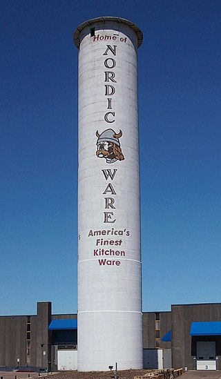
The Peavey–Haglin Experimental Concrete Grain Elevator is the world's first known cylindrical concrete grain elevator. It was built from 1899 to 1900 in St. Louis Park, Minnesota, United States, as an experiment to prove the design was viable. It was an improvement on wooden elevators that were continually at risk for catching fire or even exploding. Its cylindrical concrete design became the industry standard in the United States, revolutionizing grain storage practices. After its initial experiments, the Peavey–Haglin Elevator was never again used to store grain. Since the late 1960s it has been maintained on the grounds of the Nordic Ware company and is painted with their name and logo.

The Hull–Rust–Mahoning Open Pit Iron Mine in Hibbing, Minnesota, United States, is the largest operating open-pit iron mine in Minnesota. The pit stretches more than three miles (5 km) long, two miles (3 km) wide, and 535 feet (163 m) deep. It was established in 1895 and was one of the world's first mechanized open-pit mines.

This is a list of the National Register of Historic Places listings in Dakota County, Minnesota. It is intended to be a complete list of the properties and districts on the National Register of Historic Places in Dakota County, Minnesota, United States. Dakota County is located in the southeastern part of the U.S. state of Minnesota, bounded on the northeast side by the Upper Mississippi River and on the northwest by the Minnesota River. The locations of National Register properties and districts for which the latitude and longitude coordinates are included below, may be seen in an online map.

This is a list of the National Register of Historic Places listings in Goodhue County, Minnesota. It is intended to be a complete list of the properties and districts on the National Register of Historic Places in Goodhue County, Minnesota, United States. The locations of National Register properties and districts for which the latitude and longitude coordinates are included below, may be seen in an online map.

This is a list of the National Register of Historic Places listings in Saint Louis County, Minnesota. It is intended to be a complete list of the properties and districts on the National Register of Historic Places in Saint Louis County, Minnesota, United States. The locations of National Register properties and districts for which the latitude and longitude coordinates are included below, may be seen in an online map.

This is a list of the National Register of Historic Places listings in Pine County, Minnesota. It is intended to be a complete list of the properties and districts on the National Register of Historic Places in Pine County, Minnesota, United States. The locations of National Register properties and districts for which the latitude and longitude coordinates are included below, may be seen in an online map.

This is a list of the National Register of Historic Places listings in Le Sueur County, Minnesota. It is intended to be a complete list of the properties and districts on the National Register of Historic Places in Le Sueur County, Minnesota, United States. The locations of National Register properties and districts for which the latitude and longitude coordinates are included below, may be seen in an online map.

Hibbing High School is a public school, grades 7–12, in Hibbing, Minnesota, United States. It was built from 1920 to 1922 as the entire city relocated two miles (3 km) south to make way for the expanding Hull–Rust–Mahoning Mine. The lavish Tudor Revival building was constructed at a cost of about $3.9 million, becoming known as the "castle in the woods" and—thanks to its polished brass fixtures—the "school with the golden doorknobs". The project was bankrolled by the mining industry, which wanted to make the move more palatable for those being displaced. It also satisfied immigrants' desire for their children's education.

The Des Moines County Court House located in Burlington, Iowa, United States, was built in 1940. It was listed on the National Register of Historic Places in 2003 as a part of the PWA-Era County Courthouses of Iowa Multiple Properties Submission. The courthouse is the fourth structure to house court functions and county administration.
The Duluth Harbor North Pier Light is a lighthouse on the north breakwater of the Duluth Ship Canal in Duluth, Minnesota, United States.

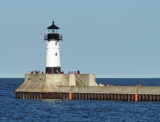
The Duluth South Breakwater Inner Light is a lighthouse on the south breakwater of the Duluth Ship Canal in Duluth, Minnesota, United States. It forms a range with the Duluth South Breakwater Outer Light to guide ships into the canal from Lake Superior. The current structure was built from 1900 to 1901.

Hibbing City Hall is the seat of local government for Hibbing, Minnesota, United States. It was built in Colonial Revival style in 1922. Hibbing City Hall was listed on the National Register of Historic Places in 1981 for its state-level significance in the themes of architecture and politics/government. It was nominated for being one of northern Minnesota's most architecturally distinctive public buildings and the longstanding seat of government for one of the largest communities of the Iron Range.
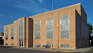
The Ely Community Center is a historic municipal building in Ely, Minnesota, United States. It was built in 1938 with funding assistance from the Public Works Administration, one of many New Deal projects designed to provide both short-term employment and lasting benefits to a community. The Ely Community Center initially housed the public library, an auditorium, meeting rooms, and offices, as well as a cafeteria and public showers. The building's design mixed Art Deco with restrained Neoclassical formalism, a style that came to be known as PWA Moderne.

The East Howard Street Commercial Historic District is a historic business district in Hibbing, Minnesota, United States. It comprises both sides of East Howard Street along the four blocks between 1st and 5th Avenues. It was the new business district designed and built for Hibbing by the Oliver Iron Mining Company from 1920 to 1921, when the company arranged to move the city a mile south to expand the Hull–Rust–Mahoning Open Pit Iron Mine. The district was listed on the National Register of Historic Places in 1993 for its local significance in the theme of community planning and development. It was nominated as a key portion of Hibbing that represents the efforts of the Oliver Iron Mining Company to relocate the entire town, and the economic importance of iron mining on the Mesabi Range.

The Delvic Building is a historic commercial building in Hibbing, Minnesota, United States. It was constructed in 1922 when Hibbing was a company town for a subsidiary of U.S. Steel, which took the unusual step of designing the commercial as well as residential sectors. In previous company towns, such as Coleraine, Minnesota, or Gary, Indiana, the controlling industry focused on employee housing and left commercial development to private entrepreneurs. The Delvic Building was listed on the National Register of Historic Places for its local significance in the themes of commerce, community planning and development, and industry. It was nominated for exemplifying the type of building constructed in Hibbing's planned downtown, and for attesting to this evolution in corporate control of community development.
The Emmett Butler House is a historic house in Hibbing, Minnesota, United States. It was built in a simplified Colonial Revival mode in 1916 for Emmett Butler, a local leader and an executive in Minnesota's influential Butler Brothers Construction Company. The house was listed on the National Register of Historic Places in 1980 for its local significance in the themes of architecture and industry. It was nominated as an example of the Colonial Revival houses built in Minnesota in the early 20th century and for its associations with Butler.

The Androy Hotel is a former hotel building in Hibbing, Minnesota, United States. It was built in 1921 by the Oliver Iron Mining Company to anchor the city's new business district, which was being relocated so the Hull–Rust–Mahoning Open Pit Iron Mine could expand. The Androy Hotel was listed on the National Register of Historic Places in 1986 for its local significance in the themes of architecture and industry. It was nominated for being a good example of a large, Renaissance Revival hotel built to serve a growing mining community. When the East Howard Street Commercial Historic District was designated in 1993, the Androy Hotel was listed as a contributing property.

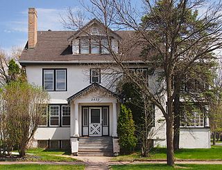
The Andrew G. Anderson House is a historic house in Hibbing, Minnesota, United States. It was built in 1920 for Andrew "Bus Andy" Anderson, a pioneer in the intercity bus service industry. The house was listed on the National Register of Historic Places in 1980 for its local significance in the themes of architecture and transportation. It was nominated for its association with Anderson and its status as one of the most lavish residences in the Hibbing area.


