
Yosemite National Park is a national park in California. It is bordered on the southeast by Sierra National Forest and on the northwest by Stanislaus National Forest. The park is managed by the National Park Service and covers 759,620 acres in four counties – centered in Tuolumne and Mariposa, extending north and east to Mono and south to Madera. Designated a World Heritage Site in 1984, Yosemite is internationally recognized for its granite cliffs, waterfalls, clear streams, giant sequoia groves, lakes, mountains, meadows, glaciers, and biological diversity. Almost 95 percent of the park is designated wilderness. Yosemite is one of the largest and least fragmented habitat blocks in the Sierra Nevada.
Acadia National Park is an American national park located along the mid-section of the Maine coast, southwest of Bar Harbor. The park includes about half of Mount Desert Island, part of the Isle au Haut, the tip of the Schoodic Peninsula, and portions of sixteen smaller outlying islands.

Bighorn Canyon National Recreation Area is a national recreation area established by an act of Congress on October 15, 1966, following the construction of the Yellowtail Dam by the Bureau of Reclamation. It is one of over 420 sites managed by the U.S. National Park Service. The recreation area spans 120,296.22 acres, straddling the border between Wyoming and Montana. It is divided into two distinct areas, the North District accessed via Fort Smith, Montana and the South District accessed through Lovell, Wyoming. There is no thru road inside the recreation area connecting the two districts. The Yellowtail Dam is located in the North District. It is named after the famous Crow leader Robert Yellowtail, harnesses the waters of the Bighorn River by turning that variable watercourse into Bighorn Lake. The lake extends 71 miles (114 km) through Wyoming and Montana, 55 miles (89 km) of which lie within the national recreation area. The lake provides recreational boating, fishing, water skiing, kayaking, and birding opportunities to visitors. About one third of the park unit is located on the Crow Indian Reservation. Nearly one-quarter of the Pryor Mountains Wild Horse Range lies within the Bighorn Canyon National Recreation Area.

Rocky Mountain National Park is an American national park located approximately 55 mi (89 km) northwest of Denver in north-central Colorado, within the Front Range of the Rocky Mountains. The park is situated between the towns of Estes Park to the east and Grand Lake to the west. The eastern and western slopes of the Continental Divide run directly through the center of the park with the headwaters of the Colorado River located in the park's northwestern region. The main features of the park include mountains, alpine lakes and a wide variety of wildlife within various climates and environments, from wooded forests to mountain tundra.

Capitol Reef National Park is an American national park in south-central Utah. The park is approximately 60 miles (97 km) long on its north–south axis and just 6 miles (9.7 km) wide on average. The park was established in 1971 to preserve 241,904 acres of desert landscape and is open all year, with May through September being the highest visitation months.

Sleeping Bear Dunes National Lakeshore is a U.S. national lakeshore in the northwestern Lower Peninsula of Michigan. Located within Benzie and Leelanau counties, the park extends along a 35-mile (56 km) stretch of Lake Michigan's eastern coastline, as well as North and South Manitou islands, preserving a total of 71,199 acres. The park is known for its outstanding natural features, including dune formations, forests, beaches, and ancient glacial phenomena. The lakeshore also contains many cultural features, including the 1871 South Manitou Island Lighthouse, three former stations of the Coast Guard, and an extensive rural historic farm district.

Haleakalā National Park is an American national park located on the island of Maui in the state of Hawaii. Named after Haleakalā, a dormant volcano within its boundaries, the park covers an area of 33,265 acres, of which 24,719 acres is a wilderness area. The land was designated a national park in 1976 and its boundaries expanded in 2005.

The Virgin Islands National Park is an American national park preserving about 60% of the land area of Saint John in the United States Virgin Islands, as well as more than 5,500 acres of adjacent ocean, and nearly all of Hassel Island, just off the Charlotte Amalie, Saint Thomas harbor.

The Flathead National Forest is a national forest in the western part of the U.S. state of Montana. The forest lies primarily in Flathead County, south of Glacier National Park. The forest covers 2,404,935 acres of which about 1 million acres (4,000 km2) is designated wilderness. It is named after the Flathead Native Americans who live in the area.

El Escorpión Park is a three-acre park located in the Simi Hills of the western San Fernando Valley, in the West Hills district of Los Angeles, California. The park contains the geographic landmark known as Escorpión Peak or Castle Peak, a 1,475-foot-tall rocky peak seen from most parts of the park and the surrounding community.

Telescope Peak is the highest point within Death Valley National Park, in the U.S. state of California. It is also the highest point of the Panamint Range, and lies in Inyo County. From atop this desert mountain one can see for over one hundred miles in many directions, including west to Mount Whitney, and east to Charleston Peak. The mountain was named for the great distance visible from the summit.

Willow River State Park is a 2,891-acre (1,170 ha) Wisconsin state park located five miles (8 km) north of Hudson. The centerpiece of the park is Willow Falls, a powerful cascade in a 200-foot (61 m) deep gorge. Another popular feature is Little Falls Lake, a shallow reservoir on the Willow River. Because of its proximity to Minneapolis-St. Paul it is one of the most visited state parks in Wisconsin. Trilobite fossils found in the lower layers of the gorge indicate the rock is around 600 million years old.
The Appalachian National Scenic Trail spans 14 U.S. states over its roughly 2,200 miles (3,500 km): Georgia, North Carolina, Tennessee, Virginia, West Virginia, Maryland, Pennsylvania, New Jersey, New York, Connecticut, Massachusetts, Vermont, New Hampshire, and Maine. The southern end is at Springer Mountain, Georgia, and it follows the ridgeline of the Appalachian Mountains, crossing many of its highest peaks and running almost continuously through wilderness before reaching the northern end at Mount Katahdin, Maine.

Devil's Punchbowl is a tilted sandstone formation on the northern slopes of the San Gabriel Mountains, in Los Angeles County, California, at an elevation of 4,750 feet (1,450 m).
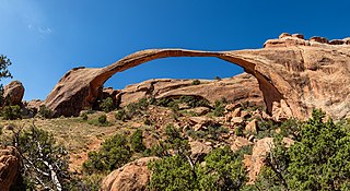
Devils Garden is an area of Arches National Park, located near Moab, Utah, United States, that features a series of rock fins and arches formed by erosion. The Devils Garden Trail, including more primitive sections and spurs, meanders through the area for 7.2 mi (11.6 km). The trailhead leads directly to Landscape Arch after a 0.8 mi (1.3 km) outbound hike, while Tunnel Arch and Pine Tree Arch can be seen on spur trails on the way to Landscape Arch. Several other arches, including Partition, Navajo, Double O, and Private Arch, as well as the Dark Angel monolith and Fin Canyon, are accessed via the primitive loop trail and its spurs.

The Backbone Trail is a long-distance trail extending 67.79 miles (109.10 km) across the length of the Santa Monica Mountains in the U.S. state of California. Its western terminus is Point Mugu State Park, and its eastern terminus is Will Rogers State Historic Park in Pacific Palisades. The trail is open to hikers throughout its length. Dogs, mountain bicyclists and horseback riders are only allowed on portions of the trail as posted.

Arches National Park is a national park in eastern Utah, United States. The park is adjacent to the Colorado River, 4 mi (6 km) north of Moab, Utah. More than 2,000 natural sandstone arches are located in the park, including the well-known Delicate Arch, as well as a variety of unique geological resources and formations. The park contains the highest density of natural arches in the world.

Joshua Tree National Park is an American national park in southeastern California, east of San Bernardino and Los Angeles and north of Palm Springs. It is named after the Joshua trees native to the Mojave Desert. Originally declared a national monument in 1936, Joshua Tree was redesignated as a national park in 1994 when the U.S. Congress passed the California Desert Protection Act. Encompassing a total of 795,156 acres – slightly larger than the state of Rhode Island – the park includes 429,690 acres of designated wilderness. Straddling San Bernardino and Riverside Counties, the park includes parts of two deserts, each an ecosystem whose characteristics are determined primarily by elevation: the higher Mojave Desert and the lower Colorado Desert. The Little San Bernardino Mountains traverse the southwest edge of the park.

The Tanawha Trail, stretching 13.5 miles (21.7 km) from Julian Price Park to Beacon Heights parallels the Blue Ridge Parkway on Grandfather Mountain in North Carolina, in the United States. Tanawha, the Cherokee word for fabulous hawk or eagle is an appropriate name for this trail that offers hikers views of distant mountains. Completed in 1993, the Tanawha Trail, like the final section of the Parkway it mirrors, is unique in construction. The trail traverses a fragile and ancient ecosystem and leads hikers through a surprising range of biological and geological terrains. Some sections tunnel through thickets of laurel and rhododendron. Others dip down into remote hardwood coves and then ascend into evergreen glens. Boulder fields and cascading streams punctuate the landscape.

Lost Palms Oasis Trail is a 7.2 mile day-hike trail located in the southernmost part of Joshua Tree National Park. The trail is generally completed in a loop. Known for the beautiful palm trees from which the trail gets its name, this hike is also known for its great bouldering, pools of water, and the ever-elusive "Victory Palms". Deemed by the National Park Service as a day-use-only area, this trail is also home to bighorn sheep who use the pools as their main source of water.
