

High Street is the main historical street and the original main thoroughfare in the centre of Newport, South Wales. Nowadays it runs approximately 280m between Westgate Square and the Old Green Interchange (facing Newport Castle).
High Street is the main historical street and the original main thoroughfare in the centre of Newport, South Wales. Nowadays it runs approximately 280m between Westgate Square and the Old Green Interchange (facing Newport Castle).

Newport's High Street leads away southwest from Newport Castle and Newport Bridge through the city centre, bending to head south approximately four-fifths of the way along its route. Landmarks along the street include the Kings Head Hotel building, the facade of the Old Post Office (now disguising a multi-storey carpark), [1] the Olde Murenger's Pub, Newport Market and Newport Arcade. Since the early 2010s the street has undergone re-paving and other improvements.
Newport, in 1810, was described as "consisting principally of one street, built partly on the banks of the Usk" [2] and this description is corroborated by the 1750 map of Newport. [3] High Street led to what is now Stow Hill and eventually to the town church, St Woolos. The town once had town walls with three gates, the middle one was in the centre of the High Street and was finally demolished in 1808. [2] The High Street was widened in 1809 and, in 1810, the development of Commercial Street began, [4] spreading the town west.
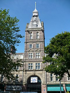
A tax collector lived on the High Street to collect money to pay for repairs to the walls [2] though the Murenger's House (a 'murenger' was a tax collector) was demolished in 1816. [4] A pub, Ye Olde Murenger House, still exists on High Street, claiming to be Newport's oldest pub operating since 1530 [5] (it was elaborated with faux jetties at some point during the 20th-century). [6] A Post Office was built on High Street in 1844, [4] rebuilt in 1907 and reconstructed in 2001 (according to the blue plaque on the building). [7]

A market took place in a block on the east side of the High Street from 1817. It was expanded in 1865 and, in May 1889 an even larger indoor market was opened, with a 58m central hall. [8] The High Street facade of the building dates from the early 1900s, in Portland stone. [8] Two covered shopping arcades run off High Street, both probably by local architects Habershon & Fawckner and both now Grade II listed. Newport Arcade to the west dates from 1893 [9] and Market Arcade, to the east, dates from circa 1900. [10]
The High Street became a one-way system for motorised vehicles in 1949. [11]
In the 2010s the High Street underwent regeneration and pedestrianisation as part of a wider £2.6 million project to improve the city centre shopping experience. [12]

Abergavenny is a market town and community in Monmouthshire, Wales. Abergavenny is promoted as a Gateway to Wales; it is approximately 6 miles (10 km) from the border with England and is located where the A40 trunk road and the A465 Heads of the Valleys road meet.

The Westgate Hotel, Commercial Street, Newport, Wales is a hotel building dating from the 19th century. On 4 November 1839 the hotel saw the major scenes of the Newport Rising, when 3,000 Chartists led by John Frost marched on Newport to attempt to secure the release of five of their number who were being held under arrest at the hotel. Around 100 British Army soldiers killed 22 of the civilian Chartists and wounded more than 50. The hotel is a Grade II listed building.

Caerleon is a town and community in Newport, Wales. Situated on the River Usk, it lies 5 miles (8 km) northeast of Newport city centre, and 5.5 miles (9 km) southeast of Cwmbran. Caerleon is of archaeological importance, being the site of a notable Roman legionary fortress, Isca Augusta, and an Iron Age hillfort. Close to the remains of Isca Augusta are the National Roman Legion Museum and the Roman Baths Museum. The town also has strong historical and literary associations: Geoffrey of Monmouth elevated the significance of Caerleon as a major centre of British history in his Historia Regum Britanniae, and Alfred Lord Tennyson wrote Idylls of the King (1859–1885) while staying in Caerleon.

Usk is a town and community in Monmouthshire, Wales, 10 miles (16 km) northeast of Newport. It is located on the River Usk, which is spanned by an arched stone bridge at the western entrance to the town. Usk Castle, above the town overlooks, the ancient crossing point. It developed as a small market town, with some industry including the making of Japanware, and with a notable prison built in 1841/2. In recent years Usk has become known for its history of success in Britain in Bloom competitions, winning the Large Village award in 2005. The resident population of the town in 2001 was 2,318, increasing to 2,834 at the 2011 census.

Chepstow is a town and community in Monmouthshire, Wales, adjoining the border with Gloucestershire, England. It is located on the tidal River Wye, about 2 miles (3.2 km) above its confluence with the River Severn, and adjoining the western end of the Severn Bridge. It is the easternmost settlement in Wales, situated 16 miles (26 km) east of Newport, 28 miles (45 km) east-northeast of Cardiff, 18 miles (29 km) northwest of Bristol and 110 miles (180 km) west of London.

Newport is a city and county borough in Wales, situated on the River Usk close to its confluence with the Severn Estuary, 12 miles northeast of Cardiff. With a population of 145,700 at the 2011 census, Newport is the third-largest authority with city status in Wales, and seventh most populous overall. Newport became a unitary authority in 1996 and forms part of the Cardiff-Newport metropolitan area. Newport was the site of the last large-scale armed insurrection in Great Britain, the Newport Rising of 1839.

Newport City Council is the governing body for Newport, one of the Principal Areas of Wales. It consists of 50 councillors, who represent the city's 20 wards.
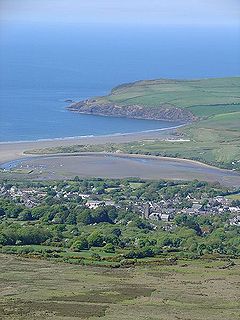
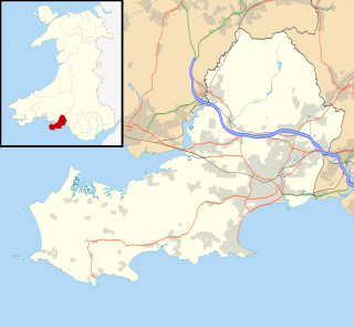
Newport is a town, parish, community, electoral ward and ancient port of Parrog, on the Pembrokeshire coast in West Wales at the mouth of the River Nevern in the Pembrokeshire Coast National Park.

Cardiff city centre is the city centre and central business district of Cardiff, Wales. The area is tightly bound by the River Taff to the west, the Civic Centre to the north and railway lines and two railway stations – Central and Queen Street – to the south and east respectively. Cardiff became a city in 1905.

Stow Hill is both an electoral district (ward) and coterminous community parish of the City of Newport, South Wales.
Swansea city centre in Swansea, Wales, contains the main shopping, leisure and nightlife district in Swansea. The city centre covers much of the Castle ward including the area around Oxford Street, Castle Square, and the Quadrant Shopping Centre; Alexandra Road, High Street, Wind Street and the Castle; Parc Tawe; and the Maritime Quarter extending down to the seafront.
Newport city centre is traditionally regarded as the area of Newport, Wales bounded by the west bank of the River Usk, the George Street Bridge, the eastern flank of Stow Hill and the South Wales Main Line. Most of the city centre is contained within two conservation areas: the central area and the area around Lower Dock Street. Most of the city centre is located in the Stow Hill district.
Newport Market is a traditional Victorian indoor market, in Newport, South Wales. It is an early example of a large-span cast iron-frame building featuring a glass-filled barrel roof.

St Mary Street and High Street are major commercial streets in the Castle Quarter of Cardiff city centre, Wales, which form a major thoroughfare running south from the gatehouse of Cardiff Castle. High Street begins at the junction of Castle Street on the A4161 and ends at the junction of Church Street and Quay Street, from where St Mary Street begins until the roundabout at Callaghan Square on the A4160.

Castle Quarter is an independent retail destination area in the north of the city centre of Cardiff, Wales. Castle is also a community (parish) of Cardiff.

Commercial Street is a 700-yard (660-metre) long main shopping street leading from the city centre of Newport, South Wales.

Ye Olde Murenger House is a 19th-century pub with a mock Tudor front on High Street, Newport, Wales. It replaced a 17th-century pub, the Fleur de Lys, on the same site. It is named after the medieval job of a murenger, a person who collected tolls for the repair of the town walls, and is Grade II listed due to its historic interest to the immediate area.

The Newport music scene, in and around Wales' third city, has been well documented and acclaimed for cultivating bands, singers, and famous music venues. It has been traditionally a rock city since the 1970s, but it has evolved over the years into forms of punk, 1990s alt-rock, and more recently metal and hip-hop.

El Sieco's is a pub, bar, and music venue in Newport, Wales which opened in 2016 on High Street, Newport, following the closure in 2010 of TJ's.
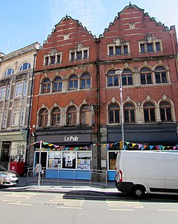
Le Pub is a bar, restaurant and nightclub located in Newport, South Wales. It opened in 1992 on nearby Cadoxton Place, and became a popular live music venue as part of the Newport music scene along with TJ's, later relocating as a co-operative on High Street.