
Highbury New Park is a street in Highbury in the London Borough of Islington which runs from Highbury Quadrant in the north to Highbury Grove in the south.
Highbury New Park is a street in Highbury in the London Borough of Islington which runs from Highbury Quadrant in the north to Highbury Grove in the south.
The road was developed by Henry Rydon from 1853 in order to attract prosperous city businessmen to the area [1] [2] and there are now a large number of grade II listed Victorian villas in the road.
14 Highbury New Park is the setting of The Ghost Downstairs by Leon Garfield (1972).

Charing Cross Road is a street in central London running immediately north of St Martin-in-the-Fields to St Giles Circus, which then merges into Tottenham Court Road. It leads from the north in the direction of Charing Cross at the south side of Trafalgar Square. It connects via St Martin's Place and the motorised east side of the square.

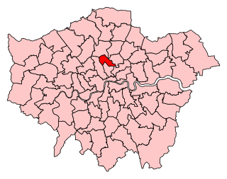
The London Borough of Islington is a London borough which forms part of Inner London, England. Islington has an estimated population of 215,667. It was formed in 1965, under the London Government Act 1963, by the amalgamation of the metropolitan boroughs of Islington and Finsbury.

The Marble Arch is a 19th-century white marble-faced triumphal arch in London, England. The structure was designed by John Nash in 1827 as the state entrance to the cour d'honneur of Buckingham Palace; it stood near the site of what is today the three-bayed, central projection of the palace containing the well-known balcony. In 1851, on the initiative of architect and urban planner Decimus Burton, a one-time pupil of John Nash, the arch was relocated to its current site, near the northeast corner of Hyde Park, so that expansion of Buckingham Palace could proceed.
Constitution Hill is a road in the City of Westminster in London. It connects the western end of The Mall with Hyde Park Corner, and is bordered by Buckingham Palace Gardens to the south, and Green Park to the north. At the top of the rise in the roadway at the Corner is the Wellington Arch, near where the road is flanked by the Memorial Gates war memorial.

Holloway Road is a road in London, 3 kilometres (1.9 mi) in length. It is one of the main shopping streets in North London, and carries the A1 road as it passes through Holloway, in the London Borough of Islington. The road starts in Archway, near Archway Underground station, then heads south-east, past Upper Holloway railway station, Whittington Park, past the North London campus of London Metropolitan University near Nag's Head, past Holloway Road Underground station, and the main campus of the university, and then becomes Highbury Corner, near Highbury & Islington station.

Holborn Viaduct is a road bridge in London and the name of the street which crosses it. It links Holborn, via Holborn Circus, with Newgate Street, in the City of London, England financial district, passing over Farringdon Street and the subterranean River Fleet. The viaduct spans the steep-sided Holborn Hill and the River Fleet valley at a length of 1,400 feet (430 m) and 80 feet (24 m) wide. City surveyor William Haywood was the architect and the engineer was Rowland Mason Ordish.

The New North Road is a road in northern central London, forming part of a link road from the A1 at Highbury into the City of London at Moorgate. It is 0.8 miles (1.3 km) in length and is part of the A1200. This link road consists of Canonbury Road and New North Road, before several smaller sections to the south leading into the city.

Bayswater Road is the main road running along the northern edge of Hyde Park in London. Originally part of the A40 road, it is now designated part of the A402 road.
Islington North is a constituency in Greater London established for the 1885 general election. It has been represented in the House of Commons of the UK Parliament since 1983 by Jeremy Corbyn, who was Leader of the Labour Party and Leader of the Opposition from 2015 to 2020. Since 2020, Corbyn has represented the seat as an independent, having been suspended for remarks he made after an investigation of antisemitism in the party. He will contest the seat in the 2024 United Kingdom general election as an independent candidate.
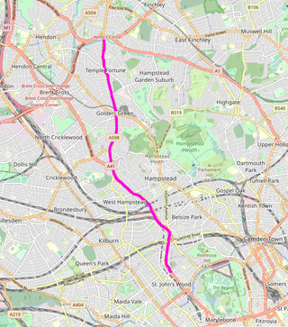
Finchley Road is a designated 4.5-mile (7-kilometre) arterial road in north-west London, England. The Finchley Road starts in St John's Wood near central London as part of the A41; its southern half is a major dual carriageway with high traffic levels often frequented by lorries and long-distance coaches as it connects central London, via the A41 Hendon Way, to the M1 motorway at Brent Cross and other roads at that interchange.

Waterlow Park is a 26-acre (11 ha) park in the south east of Highgate Village, in north London. It was given to the public by Sir Sydney Waterlow, as "a garden for the gardenless" in 1889.

Essex Road is a main road in Islington, London. It is part of the A104 and connects Islington High Street with Balls Pond Road via Essex Road railway station.

Highbury Fields is an open space in Highbury, in the London Borough of Islington. At 11.75 hectares, it is the largest open space in the borough.

The A105 road is an A road in London, England. It runs from Canonbury, in between Highbury and Dalston, to Enfield Town. The road is 8 miles (13 km) long. Part of the road forms Green Lanes, one of the longest streets in London, while the A105 also serves as the primary access route to the Shopping City shopping centre in Wood Green.

Harrow Road is an ancient route in North West London which runs from Paddington in a northwesterly direction towards Harrow. It is also the name given to the immediate surrounding area of Queens Park and Kensal Green, straddling the NW10, W10, W2 and W9 postcodes. With minor deviations in the 19th and 20th centuries, the route remains otherwise unaltered.

Mildmay Park railway station is a former railway station on the North London line, located between Canonbury and Dalston Kingsland stations. The station was located on Mildmay Park between Newington Green and Balls Pond Road.
Highbury Park is a street in Highbury, London, that runs from Blackstock Road in the north to Highbury Grove in the south.

Montrose House is a late 17th-century Grade II* listed building at 186 Petersham Road, Petersham in the London Borough of Richmond upon Thames.
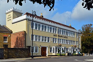
Jack Straw's Castle is a Grade II listed building and former public house on North End Way, Hampstead, north-west London, England close to the junction with Heath Street and Spaniards Road.

The Bull and Mouth Inn was a coaching inn in the City of London that dated from before the Great Fire of London in 1666. It was located between Bull and Mouth Street in the north and Angel Street in the south. It was once an important arrival and departure point for coaches from all over Britain, but particularly for the north of England and Scotland. It became the Queen's Hotel in 1830 but was demolished in 1887 or 1888 when new post office buildings were built in St Martin's Le Grand.
![]() Media related to Highbury New Park at Wikimedia Commons
Media related to Highbury New Park at Wikimedia Commons
51°33′30.76″N0°5′32.12″W / 51.5585444°N 0.0922556°W
| | This London-related article is a stub. You can help Wikipedia by expanding it. |