Nottinghamshire is a ceremonial county in the East Midlands, England. The county borders South Yorkshire to the north-west, Lincolnshire to the east, Leicestershire to the south, and Derbyshire to the west. The largest settlement is the city of Nottingham (323,632).

South Yorkshire is a ceremonial county in the Yorkshire and the Humber region of England. It borders North Yorkshire and West Yorkshire to the north, the East Riding of Yorkshire to the north-east, Lincolnshire and Nottinghamshire to the south-east, and Derbyshire to the south and west. The largest settlement is the city of Sheffield.

Woodlands is a model village 4 miles (6 km) north-west of Doncaster in South Yorkshire, England. The village lies adjacent to Highfields and Adwick le Street within the City of Doncaster. The colliery village was designed and built in the early 20th century by the architect Percy Houfton as tied cottages for the miners of the neighbouring Brodsworth Colliery. In an era of model villages such as Saltaire, Port Sunlight and Bournville, Woodlands, with extensive open spaces, many different designs of houses, and overall living conditions excellent for their time, possibly represents the height of the model village movement. The village is a conservation area.

Thorne is a market town and civil parish in the City of Doncaster in South Yorkshire, England. It was historically part of the West Riding of Yorkshire until 1974. It has a population of 16,592, increasing to 17,295 at the 2011 Census.

The City of Doncaster is a metropolitan borough with city status in South Yorkshire, England. It is named after its principal settlement, Doncaster, and includes the surrounding suburbs of Doncaster as well as numerous towns and villages. The district has large amounts of countryside; at 219 square miles (570 km2), it is the largest metropolitan borough in England by area.

Maltby is a former mining town and civil parish in the Metropolitan Borough of Rotherham, South Yorkshire, England. It was historically in the West Riding of Yorkshire. It is located about 6 miles (10 km) east of Rotherham town centre and 10 miles (16 km) north-east of Sheffield city centre. It forms a continuous urban area with Hellaby, separated from the rest of Rotherham by the M18 motorway. It had a population of 16,688 at the 2011 Census.

Middleton is a largely residential suburb of Leeds in West Yorkshire, England and historically a village in the West Riding of Yorkshire. It is situated on a hill 4 miles (6 km) south of Leeds city centre and 165 miles (266 km) north north-west of London.

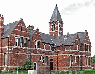
Adwick le Street is a village in the City of Doncaster, South Yorkshire, England. The Adwick ward of Doncaster Metropolitan Borough Council had a population of 15,911 at the 2011 Census. It is situated north-west of Doncaster. Under the 2011 census, the settlement had a population of 10,507.
Killamarsh is a village and civil parish in North East Derbyshire, England, bordering Rotherham to the north and Sheffield to the north-west.
Highfields is a former coal mining village, located south of the model village of Woodlands, in South Yorkshire. Historically part of the West Riding of Yorkshire, it is part of the City of Doncaster. The village is located in the Adwick ward of Doncaster MBC.
Bestwood Village is an area and civil parish in the Gedling district of Nottinghamshire. Until 1 April 2018 it was part of the civil parish of Bestwood St. Albans. A small part of the village falls within the Ashfield district council area. There have been several new housing estates built recently including the redevelopment of the former Bayles and Whylie factory site which was a former glue mill. It is to the east of Hucknall and north of Bulwell. It is neighboured to the north by the village of Papplewick. It is also close to the Bestwood Park Estate which is in the City of Nottingham.

Edlington is a town and civil parish in the City of Doncaster, South Yorkshire, England, lying to the south west of Doncaster and Warmsworth. It has a population of 8,276. The original parish town of Edlington is now known as Old Edlington; adjacent, and to the north, is New Edlington. It is often referred to by locals as 'Edlo'. Since 1974 Edlington has been part of the Metropolitan Borough of Doncaster in the metropolitan county of South Yorkshire. It had, since 1894, formed part of Doncaster Rural District in the West Riding of Yorkshire.

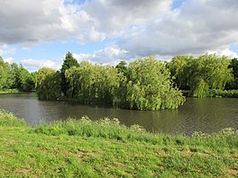
Hanging Wood is an area of woodland situated between the old Great North Road and the Roman Road, and between the mining villages of Highfields and Woodlands in South Yorkshire, England. The Woodlands wildlife park and an ornamental lake, Highfields Lake are features of the wood, as is Woodlands, a former country house, now a social club.

Bentley is a suburb of Doncaster in South Yorkshire, England two miles north of the city centre. The population of the ward within the City of Doncaster at the 2011 Census was 14,191. The Bentley built-up area subdivision had a population of 27,145.

Nidd Gorge makes up a section of the River Nidd in North Yorkshire, England, in which the river enters a deep ravine with sheer, tree covered valley sides. The river as a whole flows from its source near Great Whernside in Nidderdale, to its confluence with the River Ouse near Nun Monkton. Nidd Gorge makes up approximately 3 miles (4.8 km) of the entire length of the river, and stretches from the now defunct Nidd viaduct at Bilton in Harrogate to Grimbald Bridge, just south of Knaresborough.

The River Hipper is a tributary of the River Rother in Derbyshire, England. Its source is a large expanse of wetlands, fed by the surrounding moors between Chatsworth and Chesterfield, known as the Hipper Sick on Beeley Moor, which is part of the Chatsworth Estate. It then passes through Holymoorside and down into Chesterfield, just south of the town centre, before flowing into the River Rother. In July 2007, parts of Chesterfield flooded when the River Hipper burst its banks during a substantial storm that caused extensive flooding in North Derbyshire and South Yorkshire. The surrounding landscape is known as the Hipper Valley.

Oldcotes Dyke is the name of the final section of a river system that drains parts of north Nottinghamshire and the Metropolitan Borough of Rotherham in South Yorkshire, England. Historically, it has supported milling, with seven water mills drawing their power from its water, and ran through the grounds of the Cistercian Roche Abbey. It is a tributary of the River Ryton.

The River Burn is a river that flows wholly within North Yorkshire, England. The river starts as several small streams on Masham Moor and drains Colsterdale flowing eastwards before emptying into the River Ure just south of Masham. Conservation work on removing a weir, and introducing fish to the river in 2016, has meant that salmon have been recorded spawning in the river for the first time in over 100 years.

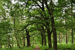
Bentley Colliery was a coal mine in Bentley, near Doncaster in South Yorkshire, England, that operated between 1906 and 1993. In common with many other mines, it suffered disasters and accidents. The worst Bentley disaster was in 1931 when 45 miners were killed after a gas explosion. The site of the mine has been converted into a woodland.

Ea Beck is a small river in South Yorkshire, England, that flows eastwards into the River Don at Thorpe-in-Balne. The Environment Agency lists the beck as starting at South Elmsall, but mapping lists the beck with several names along its course. The beck has twice flooded areas and villages that it passes through in the 21st century.