Hillingdon Civic Centre

Last updated

Hillingdon Civic Centre
Hillingdon Civic Centre, exterior 3 - Anthony Ossa-Richardson.jpg
View of part of the Civic Centre
Location Uxbridge
Coordinates 51°32′38″N0°28′34″W / 51.5439°N 0.4761°W / 51.5439; -0.4761
Built1979
Architect Andrew Derbyshire
Architectural style(s)Neo-vernacular style
Listed Building – Grade II
Designated18 April 2018
Reference no.1451218
Hillingdon London UK blank ward map.svg
Red pog.svg
Shown in Hillingdon

Hillingdon Civic Centre is a municipal building in the High Street, Uxbridge. The civic centre, which is the headquarters of Hillingdon London Borough Council, is a Grade II listed building. [1]

History

The old Uxbridge Urban District Council had acquired a house called Southfields at 265 High Street in 1927 and converted it to be its offices and meeting place, having previously met in a council chamber on the upper floors of the town's Market House. [2] [3] Middlesex County Council built itself an office building adjoining Southfields in 1939 which also included a library and clinic, with plans to later extend the building onto the site of Southfields to include a town hall and municipal offices for Uxbridge Urban District Council too. [4]

With the outbreak of the Second World War the plans for further buildings on the site were not pursued. Uxbridge became a municipal borough in 1955, and the borough council continued to be based at Southfields until it was replaced in 1965 by the London Borough of Hillingdon. [5] [6] Following the creation of the London borough in 1965, [7] civic leaders decided to procure a purpose-built civic centre. They resurrected plans to build on the site of Southfields, also incorporating the 1939 Middlesex County Council building. [8]

The new building, which was designed by Andrew Derbyshire, was acclaimed as one of the most famous buildings in the British neo-vernacular style. [9] [10] [11] [12] It was planned from 1970 and the construction work, which was undertaken by Higgs and Hill at a cost of £5.6 million, started in January 1973. [13] It opened in stages from 1976 with a formal opening by the chairman of the British Airports Authority, Norman Payne, on 28 April 1979. [14]

Front part of the building with clock tower as seen from High Street Hillingdon Civic Centre, April 2024 (3).jpg
Front part of the building with clock tower as seen from High Street

Derbyshire's design envisaged a diamond-shaped building to the west containing the offices of the council officers and their departments and a more irregular-shaped building to the east containing the public areas including the council chamber, the civic suite and register office. [8] The main frontage to the public areas, facing onto the High Street, featured a loggia with eight entrances and a steep roof, with a two-storey block with a clock tower behind. [1] The design made extensive use of brick and tile, to pay homage to traditional homely brick architecture of nearby buildings and suburban developments that were "indigenous to the borough". [15] [16] It was designated a Grade II Listed Building in April 2018. [1]

Despite its listed status, the building has had a mixed reception from architectural critics. In his 2012 essay Post Modernism to Ghost Modernism Jonathan Meades argued the building was symbolic of the political climate of its era and highlighted it as an early example of a more populist, conservative style of architecture which aspired to be inoffensive but instead came across as patronising. He concluded that “the proudly vaunting philistinism which has afflicted Britain for three decades found its first architectural expression at Hillingdon.” [17]

A distinctive yew wood sculpture, designed by John Phillips, made up of fourteen pieces of wood suspended on a wire rope, was hung in the stairwell leading up to council chamber. [8] [18]

One of the surviving parts of the 1939 Middlesex County Council building, now visible only from an internal courtyard within the 1970s building. Hillingdon Civic Centre, April 2024 (4).jpg
One of the surviving parts of the 1939 Middlesex County Council building, now visible only from an internal courtyard within the 1970s building.

Related Research Articles

<span class="mw-page-title-main">Cowley, London</span> Suburban village in the United Kingdom

Cowley is a village contiguous with the town of Uxbridge in the London Borough of Hillingdon. A largely suburban village with 16 listed buildings, Cowley is 15.4 miles (24.8 km) west of Charing Cross, bordered to the west by Uxbridge Moor in the Green Belt and the River Colne, forming the border with Buckinghamshire. Cowley was an ancient parish in the historic county of Middlesex.

<span class="mw-page-title-main">Northwood, London</span> Area in the London Borough of Hillingdon

Northwood is an area in the London Borough of Hillingdon, North West London, located 14.5 miles (23.3 km) north-west of Charing Cross. Northwood was part of the ancient parish of Ruislip, Middlesex. The area was situated on the historic Middlesex boundary with Hertfordshire, and since being incorporated into Greater London in 1965, has been on the Greater London boundary with that county.

<span class="mw-page-title-main">Ruislip</span> Area of west London, England

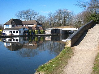
Ruislip is a suburb in the London Borough of Hillingdon in West London. Prior to 1965 it was in Middlesex. Ruislip lies 13.8 miles (22.2 km) west-north-west of Charing Cross, London.

<span class="mw-page-title-main">Uxbridge</span> Town in the west of Greater London, England

Uxbridge is a suburban town in west London and the administrative headquarters of the London Borough of Hillingdon. Situated 15.4 miles (24.8 km) west-northwest of Charing Cross, it is one of the major metropolitan centres identified in the London Plan. Uxbridge formed part of the parish of Hillingdon in the county of Middlesex, and was a significant local commercial centre from an early time. As part of the suburban growth of London in the 20th century it expanded and increased in population, becoming a municipal borough in 1955, and has formed part of Greater London since 1965.

<span class="mw-page-title-main">Yiewsley</span> Suburban village in the United Kingdom

Yiewsley is a large suburban village in the London Borough of Hillingdon, England, 2 miles (3 km) south of Uxbridge, the borough's commercial and administrative centre. Yiewsley was a chapelry in the ancient parish of Hillingdon, Middlesex. The population of the ward was 12,979 at the 2011 Census.

<span class="mw-page-title-main">London Borough of Hillingdon</span> London borough in United Kingdom

The London Borough of Hillingdon is the largest and westernmost borough in West London, England. It was formed in 1965 from the districts of Hayes and Harlington, Ruislip-Northwood, Uxbridge, and Yiewsley and West Drayton in the ceremonial county of Middlesex. Today, Hillingdon is home to Heathrow Airport and Brunel University, and is the second largest of the 32 London boroughs by area.

<span class="mw-page-title-main">RAF Uxbridge</span> Air force base in the UK

RAF Uxbridge was a Royal Air Force (RAF) station in Uxbridge, within the London Borough of Hillingdon, occupying a 44.6-hectare (110-acre) site that originally belonged to the Hillingdon House estate. The British Government purchased the estate in 1915, three years before the founding of the RAF. Until the outbreak of the Second World War in 1939, the station was open to the public.

<span class="mw-page-title-main">Hillingdon</span> Suburban area within the London Borough of Hillingdon

Hillingdon is an area of Uxbridge within the London Borough of Hillingdon, centred 14.2 miles (22.8 km) west of Charing Cross. It was an ancient parish in Middlesex that included the market town of Uxbridge. During the 1920s the civil parish bore a rapid, planned increase in population and housing, and was absorbed by Uxbridge Urban District in 1929. It has formed part of Greater London since 1965.

<span class="mw-page-title-main">Municipal Borough of Uxbridge</span>

Uxbridge was a local government district in north west Middlesex, England, from 1849 to 1965, seated in the town of Uxbridge.

<span class="mw-page-title-main">Yiewsley and West Drayton Urban District</span>

Yiewsley and West Drayton was a local government district in Middlesex, England from 1929 to 1965. Its area became the south-west of the London Borough of Hillingdon.

<span class="mw-page-title-main">Waterside (building)</span>

The Waterside building in Harmondsworth, Greater London, is the international head office of British Airways; it also houses the operational head office of BA's parent company, International Airlines Group (IAG). The building and landscaping, which cost £200 million, is on Harmondsworth Moor, northwest of Heathrow Airport, between the M4 and the M25 motorways in the linear Colne Valley regional park. Waterside is on the western edge of Greater London, near West Drayton and Uxbridge, in the Borough of Hillingdon

<span class="mw-page-title-main">Ruislip Woods</span> Woodland in Ruislip, London

Ruislip Woods is a Site of Special Scientific Interest and national nature reserve covering 726 acres (294 ha) in Ruislip in the London Borough of Hillingdon. The woods became London's first national nature reserve in May 1997. Ruislip Local Nature Reserve at TQ 090 899 is part of the national nature reserve.

<span class="mw-page-title-main">Brent Town Hall</span> Municipal building in London, England

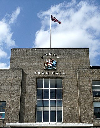
Brent Town Hall, formerly Wembley Town Hall, is a landmark building in Wembley Park in the London Borough of Brent, northwest London, England. The building is T-shaped, with a long façade on Forty Lane. The building was the seat of Brent London Borough Council until 2013 and is now occupied by the Lycée International de Londres Winston Churchill. It is a Grade II listed building.

<span class="mw-page-title-main">Highgrove House, Eastcote</span> Country house in Eastcote, London

Highgrove House, also known as High Grove House or High Grove, is a Grade II listed mansion in the suburban area of Eastcote, within the London Borough of Hillingdon. Originally built in 1750 by the Reverend John Lidgould, the house was rebuilt in 1881 by Sir Hugh Hume-Campbell following a catastrophic fire. Along with Haydon Hall and Eastcote House, Highgrove was one of the three main houses of Eastcote and eventually became a residential hostel for homeless families, run by the local council from the 1960s until 2007. An area of the estate was sold to the local council in 1935 by the then-owner Eleanor Warrender to become what is now Warrender Park. In 1975, the house was granted Grade II listed status on account of its special architectural character.

<span class="mw-page-title-main">The Chimes, Uxbridge</span> Shopping mall in Greater London, England

The Chimes is a shopping centre in Uxbridge, within the London Borough of Hillingdon, owned by the Malaysian pension fund Kumpulan Persaan. Opened in February 2001, the centre includes 71 stores, cafes and restaurants, including Boots, H&M and Next as anchor stores. A multi-screen Odeon cinema with an IMAX screen is also part of the centre. A number of existing old buildings in Uxbridge High Street were restored and incorporated into the new shopping centre, which was designed with the intention of it blending into its surroundings.

<span class="mw-page-title-main">Hillingdon London Borough Council</span>

Hillingdon London Borough Council, which styles itself Hillingdon Council, is the local authority for the London Borough of Hillingdon in Greater London, England. It is a London borough council, one of 32 in London. The council has been under Conservative majority control since 2006. The council is based at Hillingdon Civic Centre in Uxbridge.

<span class="mw-page-title-main">Andrew Derbyshire</span> British architect

Sir Andrew George Derbyshire FRIBA was a British architect. He was a senior partner, later Chairman, and following retirement, President, of the architectural practice Robert Matthew Johnson-Marshall (RMJM) and Partners, under the original named-partner architects. He was knighted in 1986.

<span class="mw-page-title-main">Southall Town Hall</span> Municipal building in London, England

Southall Town Hall is a municipal building in High Street, Southall, London. It has been designated a local heritage asset.

<span class="mw-page-title-main">Harrow Civic Centre</span> Municipal building in London, England

Harrow Civic Centre was a municipal building in Station Road, Harrow, London. It was completed in 1973 as the headquarters of Harrow London Borough Council, and closed in 2023 pending demolition.

<span class="mw-page-title-main">Sutton Civic Offices</span> Municipal building in London, England

Sutton Civic Offices is a municipal facility in St Nicholas Way, Sutton, London. It is the headquarters of Sutton London Borough Council.

References

  1. 1 2 3 Historic England. "Details from listed building database (1451218)". National Heritage List for England . Retrieved 28 November 2018.
  2. "Uxbridge and District News: History in the making". Middlesex Advertiser and County Gazette. Uxbridge. 15 April 1927. p. 9. Retrieved 20 April 2024.
  3. "Uxbridge Council Offices in Uxbridge High Street". London Picture Archive. Retrieved 20 April 2024.
  4. Cotton, Carolynne (1994). Uxbridge Past. London: Historical Publications. pp. 121–125. ISBN   0948667303.
  5. Municipal Year Book. 1947. p. 1134. Retrieved 20 April 2024.
  6. Bolton, Diane K; King, H P F; Wyld, Gillian; Yaxley, D C (1971). "'Hillingdon, including Uxbridge: Local government', in A History of the County of Middlesex: Volume 4, Harmondsworth, Hayes, Norwood With Southall, Hillingdon With Uxbridge, Ickenham, Northolt, Perivale, Ruislip, Edgware, Harrow With Pinner, ed. T F T Baker, J S Cockburn and R B Pugh". London: British History Online. pp. 82–87. Retrieved 7 September 2020.
  7. "Local Government Act 1963". Legislation.gov.uk. Retrieved 27 April 2020.
  8. 1 2 3 "London's Town Halls". Historic England. p. 111. Retrieved 5 May 2020.
  9. Charles Jencks (2002). The New Paradigm in Architecture: The Language of Post-modernism. Yale University Press. pp. 68–9. ISBN   978-0-300-09513-5.
  10. Dennis J. De Witt; Elizabeth R. De Witt (1987). Modern Architecture in Europe: A Guide to Buildings Since the Industrial Revolution. Penguin Group USA. p. 189. ISBN   978-0-525-24415-8.
  11. Thom Gorst (2 September 2003). The Buildings Around Us. Taylor & Francis. p. 132. ISBN   978-1-135-82328-3.
  12. Raphael Samuel (11 September 2012). Theatres of Memory: Past and Present in Contemporary Culture. Verso Books. p. 127. ISBN   978-1-84467-935-5.
  13. "Hillingdon Civic Centre". AJ Buildings Library. Retrieved 7 September 2020.
  14. "About the Civic Centre". London Borough of Hillingdon . Retrieved 4 November 2016.
  15. Andrew Rosen (2003). The Transformation of British Life 1950-2000: A Social History. Manchester University Press. pp. 136–8. ISBN   978-0-7190-6612-2.
  16. Bridget Cherry; Nikolaus Pevsner (1 March 1991). London 3: North West. Yale University Press. pp. 359–360. ISBN   978-0-300-09652-1.
  17. Meades, Jonathan (2013). Museum without walls. London. ISBN   978-1-78352-019-0. OCLC   858011155.{{cite book}}: CS1 maint: location missing publisher (link)
  18. "Hillingdon Civic Centre". Geo-caching. Retrieved 7 September 2020.