Hills Road, Cambridge

Last updated

The Laboratory of Molecular Biology building on Hills Road, part of the University of Cambridge. Laboratory of Molecular Biology.jpg
The Laboratory of Molecular Biology building on Hills Road, part of the University of Cambridge.
Homerton College, on Hills Road. Homerton cavendish building.jpg
Homerton College, on Hills Road.
General view of Addenbrooke's Hospital at the southeastern end of Hills Road. Addenbrooke's hospital.JPG
General view of Addenbrooke's Hospital at the southeastern end of Hills Road.

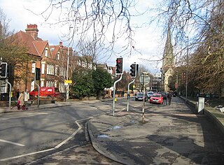
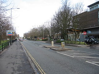
Hills Road is an arterial road (part of the A1307) in southeast Cambridge, England. [1] [2] It runs between Regent Street at the junction with Lensfield Road and Gonville Place (the A603) to the northwest and a roundabout by the Cambridge Biomedical Campus, continuing as Babraham Road (also part of the A1307) to the southeast.

The A1307 is a secondary class A road in Cambridgeshire and Suffolk between the A14 at junction 31 in Cambridge to Haverhill, Suffolk. From 2020 the former A14 between North of Cambridge and Huntingdon is reclassified as the A1307.

Cambridge City and non-metropolitan district in England

Cambridge is a university city and the county town of Cambridgeshire, England, on the River Cam approximately 50 miles (80 km) north of London. At the United Kingdom Census 2011, its population was 123,867 including 24,506 students. Cambridge became an important trading centre during the Roman and Viking ages, and there is archaeological evidence of settlement in the area as early as the Bronze Age. The first town charters were granted in the 12th century, although modern city status was not officially conferred until 1951.

England Country in north-west Europe, part of the United Kingdom

England is a country that is part of the United Kingdom. It shares land borders with Wales to the west and Scotland to the north-northwest. The Irish Sea lies west of England and the Celtic Sea lies to the southwest. England is separated from continental Europe by the North Sea to the east and the English Channel to the south. The country covers five-eighths of the island of Great Britain, which lies in the North Atlantic, and includes over 100 smaller islands, such as the Isles of Scilly and the Isle of Wight.

On the corner with Lensfield Road is Our Lady and the English Martyrs Church. To the west of the road is the Cambridge University Botanic Garden. At this point, near the Cambridge War Memorial, Station Road leads to Cambridge railway station to the east. Near the southeast end to the west, just north of the junction with Long Road, is The Perse School, an independent school. The Cambridge Biomedical Campus is to the southwest of the roundabout at the southeastern end, at the edge of the city and houses Addenbrooke's Hospital. The original hospital was located on the Old Addenbrooke's Site on Trumpington Street in central Cambridge.

Our Lady and the English Martyrs Church Church in Cambridge, United Kingdom

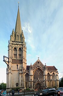
The Church of Our Lady and the English Martyrs (OLEM) is an English Roman Catholic parish church located at the junction of Hills Road and Lensfield Road in south east Cambridge. It is a large Gothic Revival church built between 1885 and 1890.

Cambridge University Botanic Garden botanical garden

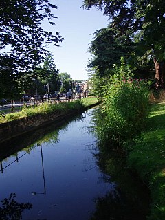
The Cambridge University Botanic Garden is a botanical garden located in Cambridge, England associated with the university Department of Plant Sciences. It lies between Trumpington Road to the west, Bateman Street to the north and Hills Road to the east.

Cambridge War Memorial Cambridge, Cambridgeshire, CB2

Cambridge War Memorial is a war memorial on Hills Road, Cambridge, outside Cambridge University Botanic Garden. It comprises a bronze statue of a marching soldier by Canadian sculptor Robert Tait McKenzie, known as "The Homecoming" or sometimes "Coming Home", mounted on a heavily carved limestone plinth. It was unveiled in 1922, and became a Grade II listed building in 1996.

Also on Hills Road are:

Homerton College, Cambridge college of the University of Cambridge

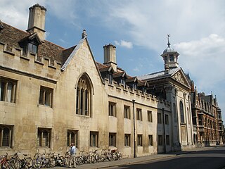
Homerton College is a constituent college of the University of Cambridge. Its first premises were acquired in London in 1768, by an informal gathering of Protestant dissenters with origins in the seventeenth century. In 1894 the College moved from Homerton High Street, Hackney, London, to Cambridge. Homerton was admitted as an "Approved Society" of the university in 1976, and received its Royal charter in 2010 affirming its status as a full college of the university. The College celebrated its 250th anniversary in 2018.

University of Cambridge University in Cambridge, United Kingdom

The University of Cambridge is a collegiate public research university in Cambridge, United Kingdom. Founded in 1209 and granted a Royal Charter by King Henry III in 1231, Cambridge is the second-oldest university in the English-speaking world and the world's fourth-oldest surviving university. The university grew out of an association of scholars who left the University of Oxford after a dispute with the townspeople. The two 'ancient universities' share many common features and are often referred to jointly as 'Oxbridge'. The history and influence of the University of Cambridge has made it one of the most prestigious universities in the world.

The Perse School independent school in Cambridge, UK

The Perse School is a co-educational independent day school in Cambridge, England. Founded in 1615 by Stephen Perse, its motto is Qui facit per alium facit per se, taken to mean 'He who does things for others does them for himself'. The School began accepting girls at 11 and 13+ in September 2010 and was fully co-educational by September 2012.

Related Research Articles

Addenbrookes Hospital Hospital in Cambridge, England

Addenbrooke's Hospital is an internationally renowned teaching hospital and research centre in Cambridge, England, with strong affiliations to the University of Cambridge. Addenbrooke's Hospital is based on the Cambridge Biomedical Campus. The hospital is run by Cambridge University Hospitals NHS Foundation Trust and is a designated academic health science centre. It is also the East of England's Major Trauma Centre - the first of which to be operational in the UK.

A52 road Major road in the East Midlands of England

The A52 is a major road in the East Midlands, England. It runs east from a junction with the A53 at Newcastle-under-Lyme near Stoke-on-Trent via Ashbourne, Derby, Stapleford, Nottingham, West Bridgford, Bingham, Grantham, Boston and Skegness to the east Lincolnshire coast at Mablethorpe. It is approximately 147 miles (237 km) long.

The Cambridge University Hospitals NHS Foundation Trust is one of the United Kingdom's NHS foundation trusts. It was originally named Addenbrooke's NHS Trust. It became a foundation trust and was renamed in 2004.

Hobsons Conduit

Hobson's Conduit, also called Hobson's Brook, is a watercourse that was built from 1610 to 1614 by Thomas Hobson and others to bring fresh water into the city of Cambridge, England from springs at Nine Wells, a Local Nature Reserve, near the village of Great Shelford. It is now a Scheduled Ancient Monument and historical relic. The watercourse currently runs overground until Cambridge University Botanic Garden and Brookside, where it is at its widest. At the corner of Lensfield Road stands a hexagonal monument to Hobson, which once formed part of the market square fountain, and was moved to this location in 1856, after a fire in the Market. The flow of water runs under Lensfield Road, and subsequently runs along both sides of Trumpington Street in broad gutters towards Peterhouse and St Catharine's College, and also St Andrew's Street. The conduit currently ends at Silver Street.

School of Clinical Medicine, University of Cambridge

The School of Clinical Medicine is the medical school of the University of Cambridge in England. According to the QS World University Rankings 2016, it ranks as the 3rd best medical school in the world. The school is co-located with Addenbrooke's Hospital on the Cambridge Biomedical Campus.

Cambridge Biomedical Campus research institute located in Cambridge, England

The Cambridge Biomedical Campus is the largest centre of medical research and health science in Europe. Located at the southern end of Hills Road in Cambridge, England the campus is managed by the University of Cambridge. The site is funded by organisations such as the Cambridge University Hospitals NHS Foundation Trust, the Wellcome Trust, Cancer Research UK, the UK government's Medical Research Council and has National Institute for Health Research Biomedical Research Centre status. It is an accredited UK academic health science centre and home to Addenbrooke's Hospital and the university's medical school.

The A607 is an A road in England that starts in Leicester and heads northeastwards through Leicestershire and the town of Grantham, Lincolnshire, terminating at Bracebridge Heath, a village on the outskirts of Lincoln. It is a primary route from Thurmaston to the A1 junction at Grantham.

The Wolfson Brain Imaging Centre (WBIC) is a leading UK Biomedical Imaging Centre, located at Addenbrooke's Hospital, Cambridge, England, on the Cambridge Bio-Medical Campus at the southwestern end of Hills Road. It is a division of the Department of Clinical Neurosciences of the University of Cambridge.

Trumpington Street street in central Cambridge, England

Trumpington Street is a major historic street in central Cambridge, England. At the north end it continues as King's Parade where King's College is located. To the south it continues as Trumpington Road, an arterial route out of Cambridge, at the junction with Lensfield Road.

Trumpington Road

Trumpington Road is an arterial road in southeast central Cambridge, England. It runs between the junction of Trumpington Street and Lensfield Road at the northern end to the junction of the High Street in the village of Trumpington and Long Street at the southern end. The Fen Causeway leads off to the west near the northern end, over Coe Fen and the River Cam.

Downing Street, Cambridge street in central Cambridge, England

Downing Street is a street in central Cambridge, England. It runs between Pembroke Street and Tennis Court Road at the western end and a T-junction with St Andrew's Street at the eastern end. Corn Exchange Street and St Tibbs Row lead off to the north. Downing Place leads off to the south.

St Andrews Street, Cambridge major street in Cambridge, England

St Andrew's Street is a major street in central Cambridge, England. It runs between Sidney Street, at the junction with Hobson Street, to the northwest and Regent Street to the southeast. Downing Street leads off to the west.

Regent Street, Cambridge

Regent Street is an arterial street in southeast central Cambridge, England. It runs between St Andrew's Street, at the junction with Park Terrace, to the northwest and Hills Road at the junction with the A603 to the southeast. Regent Terrace runs in parallel immediately to the northeast. Beyond that is Parker's Piece, a large grassed area with footpaths.

Market Hill, Cambridge

Market Hill is the location of the marketplace in central Cambridge, England. Operating as a marketplace since Saxon times, a daily outdoor market with stalls continues to run there.

Lensfield Road

Lensfield Road is a road in southeast central Cambridge, England. It runs between the junction of Trumpington Street and Trumpington Road to the west and the junction of Regent Street and Hills Road to the west. It continues as Gonville Place to the northeast past Parker's Piece, a large grassed area with footpaths.

Chesterton Road, Cambridge

Chesterton Road is a road in the north of Cambridge, England. The southwestern part of the road is known as Chesterton Lane. This links with Northampton Street at the junction with Castle Street to the northwest and Magdalene Street leading southeast across the River Cam into central Cambridge. At the northeastern end there is a roundabout, linking with Elizabeth Way to the south, continuing Cambridge's inner ring road to the east. Halfway along Chesterton Road there is a major junction with Victoria Road northwest and Milton Road northeast and Victoria Avenue over the Cam on Victoria Avenue Bridge to the south. Chesterton Lane and Chesterton Road form the northern part of the Cambridge inner ring road and thus have heavy traffic at times.

Gonville Place

Gonville Place is a road in southeast central Cambridge, England. It forms part of the city's inner ring road. At the southwest end is the junction of Regent Street and Hills Road, where the road continues as Lensfield Road. At the northeast end is the junction of Parkside and Mill Road, where the road continues as East Road, a dual carriageway.

Old Addenbrookes Site site owned by the University of Cambridge

The Old Addenbrooke's Site is a site owned by the University of Cambridge in the south of central Cambridge, England. It is located on the block formed by Fitzwilliam Street to the north, Tennis Court Road to the east, Lensfield Road to the south, and Trumpington Street to the west.

Cambridge Academy for Science and Technology

Cambridge Academy for Science and Technology is a university technical college opened in 2014. It is located on the Biomedical Campus, which encompasses Addenbrooke's Hospital, next to the Long Road Sixth Form College in Cambridge. The school is a member of the Cambridge Academic Partnership along with Parkside Community College, Coleridge Community College, Trumpington Community College, and Parkside Sixth. The formal ceremony to celebrate the change of name and to mark the school becoming a member of the Parkside Federation took place at the school premises on 19 September 2017.

References

Coordinates: 52°10′58″N0°08′24″E / 52.18282°N 0.14001°E / 52.18282; 0.14001

Geographic coordinate system Coordinate system

A geographic coordinate system is a coordinate system that enables every location on Earth to be specified by a set of numbers, letters or symbols. The coordinates are often chosen such that one of the numbers represents a vertical position and two or three of the numbers represent a horizontal position; alternatively, a geographic position may be expressed in a combined three-dimensional Cartesian vector. A common choice of coordinates is latitude, longitude and elevation. To specify a location on a plane requires a map projection.