
Thomas Hobson was an English carrier, best known as the origin of the expression Hobson's choice.

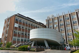
Addenbrooke's Hospital is a large teaching hospital and research centre in Cambridge, England, with strong affiliations to the University of Cambridge. Addenbrooke's Hospital is located on the Cambridge Biomedical Campus. It is run by Cambridge University Hospitals NHS Foundation Trust and is a designated academic health science centre. It is also the East of England's major trauma centre and was the first such centre to be operational in the United Kingdom.

Parker's Piece is a 25-acre (100,000 m2) flat and roughly square green common located near the centre of Cambridge, England, regarded by some as the birthplace of the rules of association football. The two main walking and cycling paths across it run diagonally, and the single lamp-post at the junction is colloquially known as Reality Checkpoint. The area is bounded by Park Terrace, Parkside, Gonville Place, and Regent Terrace. The Cambridge University Football Club Laws were first used on Parker's Piece and adopted by the Football Association in 1863. "They embrace the true principles of the game, with the greatest simplicity". 'The Cambridge Rules appear to be the most desirable for the Association to adopt'.

Hobson's Conduit, also called Hobson's Brook, is a watercourse that was built from 1610 to 1614 by Thomas Hobson and others to bring fresh water into the city of Cambridge, England from springs at Nine Wells, a Local Nature Reserve, near the village of Great Shelford. It is now a Scheduled Ancient Monument and historical relic. The watercourse currently runs overground until Cambridge University Botanic Garden and Brookside, where it is at its widest. At the corner of Lensfield Road stands a hexagonal monument to Hobson, which once formed part of the market square fountain, and was moved to this location in 1856, after a fire in the Market. The flow of water runs under Lensfield Road, and subsequently runs along both sides of Trumpington Street in broad gutters towards Peterhouse and St Catharine's College, and also St Andrew's Street. The conduit currently ends at Silver Street.
Trumpington Street is a major historic street in central Cambridge, England. At the north end it continues as King's Parade where King's College is located. To the south it continues as Trumpington Road, an arterial route out of Cambridge, at the junction with Lensfield Road.

Trumpington Road is an arterial road in southeast central Cambridge, England. It runs between the junction of Trumpington Street and Lensfield Road at the northern end to the junction of the High Street in the village of Trumpington and Long Road at the southern end. The Fen Causeway leads off to the west near the northern end, over Coe Fen and the River Cam.

Downing Street is a street in central Cambridge, England. It runs between Pembroke Street and Tennis Court Road at the western end and a T-junction with St Andrew's Street at the eastern end. Corn Exchange Street and St Tibbs Row lead off to the north. Downing Place leads off to the south.

Tennis Court Road is a historic street in central Cambridge, England. It runs parallel with Trumpington Street to the west and Regent Street to the east. At the northern end is a junction with Pembroke Street to the west and Downing Street to the east. To the south as a T-junction with Lensfield Road. Fitzwilliam Street leads off the road to the west towards the Fitzwilliam Museum.

St Andrew's Street is a major street in central Cambridge, England. It runs between Sidney Street, at the junction with Hobson Street, to the northwest and Regent Street to the southeast. Downing Street leads off to the west.

Regent Street is an arterial street in southeast central Cambridge, England. It runs between St Andrew's Street, at the junction with Park Terrace, to the northwest and Hills Road at the junction with the A603 to the southeast. Regent Terrace runs in parallel immediately to the northeast. Beyond that is Parker's Piece, a large grassed area with footpaths.
Hills Road is an arterial road in southeast Cambridge, England. It runs between Regent Street at the junction with Lensfield Road and Gonville Place to the northwest and a roundabout by the Cambridge Biomedical Campus, continuing as Babraham Road to the southeast.

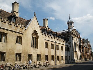
Market Hill is the location of the marketplace in central Cambridge, England. Operating as a marketplace since Saxon times, a daily outdoor market with stalls continues to run there.
Gonville Place is a road in southeast central Cambridge, England. It forms part of the city's inner ring road. At the southwest end is the junction of Regent Street and Hills Road, where the road continues as Lensfield Road. At the northeast end is the junction of Parkside and Mill Road, where the road continues as East Road, a dual carriageway.

The Church of Our Lady of the Assumption and the English Martyrs, also known as the Church of Our Lady and the English Martyrs (OLEM), is an English Roman Catholic parish church located at the junction of Hills Road and Lensfield Road in southeast Cambridge. It is a large Gothic Revival church built between 1885 and 1890, and is a Grade I listed building. It is the tallest building in Cambridge at 65m tall.

The Old Addenbrooke's Site is a site owned by the University of Cambridge in the south of central Cambridge, England. It is located on the block formed by Fitzwilliam Street to the north, Tennis Court Road to the east, Lensfield Road to the south, and Trumpington Street to the west.
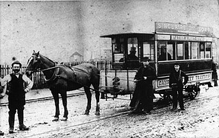
Cambridge Street Tramways operated a horse-drawn tramway service in Cambridge, England, between 1880 and 1914.

Great Kneighton is a large housing development and residential area in the southern part of the City of Cambridge district of Cambridgeshire, adjacent to, and integrated with, the neighbouring village of Trumpington. Together with nearby development Trumpington Meadows, it forms part of the southern fringe expansion of the city. Currently nearing completion by developers Countryside Properties, it will ultimately consist of almost 2,300 homes.

The following is a timeline of the history of the city of Cambridge, England.
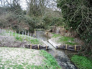
Nine Wells is a 1.2 hectare Local Nature Reserve east of Trumpington, on the southern outskirts of Cambridge. It is owned and managed by Cambridge City Council.
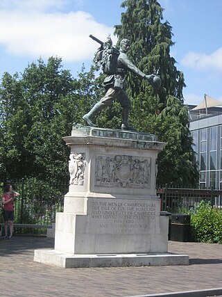
Cambridge War Memorial is a war memorial on Hills Road, Cambridge, outside Cambridge University Botanic Garden. It comprises a bronze statue of a marching soldier by Canadian sculptor Robert Tait McKenzie, known as "The Homecoming" or sometimes "Coming Home", mounted on a heavily carved limestone plinth. It was unveiled in 1922, and became a Grade II listed building in 1996.


