Related Research Articles

Richmond is a city in western Contra Costa County, California, United States. The city was incorporated on August 7, 1905, and has a city council. Located in the San Francisco Bay Area's East Bay region, Richmond borders San Pablo, Albany, El Cerrito and Pinole in addition to the unincorporated communities of North Richmond, Hasford Heights, Kensington, El Sobrante, Bayview-Montalvin Manor, Tara Hills, and East Richmond Heights, and for a short distance San Francisco on Red Rock Island in the San Francisco Bay. Richmond is one of two cities, the other being San Rafael, that sits on the shores of both San Francisco Bay and San Pablo Bay.

Point Pinole Regional Shoreline is a regional park on the shores of the San Pablo Bay, California, in the United States. It is approximately 2,315 acres (9.37 km2) in area, and is operated by the East Bay Regional Park District. It includes the Dotson Family Marsh and the Point Pinole Lagoon and hosts the North Richmond Shoreline Festival.
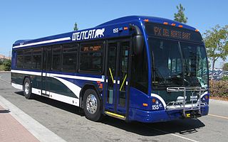
WestCAT is a public transportation service in western Contra Costa County. It is a service of the Western Contra Costa Transit Authority.
Point Richmond, also sometimes referred to locally as The Point, is a neighborhood in Richmond, California, United States, near the eastern end of the Richmond-San Rafael Bridge, between Interstate 580 and the San Francisco Bay.

The Richmond Parkway Transit Center or RPTC is a park and ride lot and bus terminal located in Richmond, California. It is named after the adjacent Richmond Parkway. It serves as a transfer point for the WestCAT and AC Transit. It is located on the corner of Richmond Parkway and Blume Drive near the Pinole border and adjacent to Interstate 80 and the Hilltop Plaza shopping center.

Fairmede-Hilltop, more commonly known simply as Hilltop, is a neighborhood located in the northeastern area of Richmond, California.

Richmond Heights, formerly East Richmond and also known as Mira Vista, is a district of eastern Richmond, California in the San Francisco Bay Area.
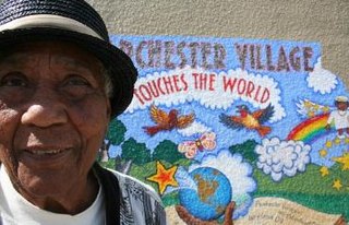
Parchester Village is a planned majority African-American village in northwestern Richmond, California that was the first in the state to sell to blacks.

The Richmond Country Club is a private social gathering place and sports facility for golf in the Hilltop District of Richmond, California, United States.
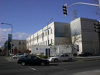
Kaiser Richmond Medical Center is a large Kaiser Permanente hospital in downtown Richmond, California which serves 77,000 members registered under its medical plans. It opened in 1995 replacing the historic 1942 Richmond Field Hospital that serviced Liberty shipyard workers and thus gave birth to the HMO. However it was deemed seismically unsafe and this new campus was built.

Downtown Richmond is the old center of Richmond, California. The area is roughly bordered by 6th street to the west, 23rd Street to the east, Barrett Avenue to the north, and Macdonald Avenue to the south. The area once featured major department stores and other chains such as J.C. Penney, Macy's, S. H. Kress & Co., and Sears before Hilltop Mall was built in the 1970s.The area is currently undergoing a revitalization effort by the city, which has included the Richmond Shopping Center anchored by a supermarket. The Richmond Transit Village—coined Metro Walk by the developers, the Olson Company—has also been built, along with remodeling of the Richmond BART and Amtrak station and a bus transit center served by AC Transit and Golden Gate Transit. A Kaiser Permanente hospital and a Social Security Administration processing center provide for a majority of the jobs in the area.

West County Detention Center is a large coeducational adult medium security Contra Costa County jail in Richmond, California opened in 1991.

Downtown Oakland is the central business district of Oakland, California, United States; roughly bounded by both the Oakland Estuary and Interstate 880 on the southwest, Interstate 980 on the northwest, Grand Avenue on the northeast, and Lake Merritt on the east.

Hercules Transit Center is a major commuter hub in the western Contra Costa County city of Hercules, California. It is anchored by WestCAT bus services. The center was originally on San Pablo Avenue. In August 2009, the transit center was relocated to the other side of I-80 with additional paid parking.

Macdonald 80 Shopping Center, or Macdonald 80, is a 200,000 sq. ft. (18,580m³) regional shopping mall in the North & East neighborhood in Richmond, California, anchored by a Target store. The center was largely demolished and rebuilt after suffering from urban decay and blight. It is the only entirely LEED certified mall. It is anchored by a large Target store.

The Santa Rosa Transit Mall is a major transfer point for several bus routes serving the city of Santa Rosa, California, located in Sonoma County, north of San Francisco, in the United States. From the Transit Mall, passengers can travel throughout Santa Rosa and Sonoma County, plus destinations that connect the city with the rest of the San Francisco Bay Area and the Redwood Empire.
Hilltop Lake Park, United States, is a city of Richmond, California park in the San Francisco Bay Area situated at Richmond Parkway and Lakeside Drive in the Hilltop neighborhood. The park encompasses Hilltop Lake and several tributaries of Garrity Creek, a grasslands covered canyon. It is located between housing and Hilltop Mall Shopping Center and is a small pristine area surrounded by otherwise developed urban and suburban areas consisting of waterfowl and wildlife wetlands habitat. The park has 35 acres and the city is trying to further develop the park with a small visitor center, pier in the lake, trails, and accessibility with the surrounding area including the Richmond-Hilltop Y.M.C.A..
Abella Center formerly International Marketplace and originally El Portal Shopping Center is a mixed-use city services, business, shopping center and housing village transit-oriented development that was formerly a mall in San Pablo, California.

Doctors Medical Center was an eight-story, 120-bed public hospital in San Pablo, California which served 250,000 residents in western Contra Costa County from 1954 to 2015.

Power is a light rail station in Salt Lake City, Utah, served by the Green Line of the Utah Transit Authority's (UTA) TRAX system. The Green Line provides service from the Salt Lake City International Airport to West Valley City, and connects with the rest of the TRAX system, as well as UTA's FrontRunner commuter rail and S Line streetcar.
References
- ↑ Chris Treadway: Richmond temple plans Holocaust remembrance event, Chris Treadway, Contra Costa Times , 16-04-2012, access date 19-04-2012
| | This Contra Costa County, California–related article is a stub. You can help Wikipedia by expanding it. |