Hindsford

Last updated

Hindsford
St Anne's Church, Atherton.jpg
St Anne's Church
Greater Manchester UK location map 2.svg
Red pog.svg
Hindsford
Location within Greater Manchester
OS grid reference SD683023
  London 170 mi (274 km) SE
Metropolitan borough
Metropolitan county
Region
Country England
Sovereign state United Kingdom
Post town MANCHESTER
Postcode district M46
Dialling code 01942
Police Greater Manchester
Fire Greater Manchester
Ambulance North West
UK Parliament
List of places
UK
England
Greater Manchester
53°31′02″N2°28′43″W / 53.5173°N 2.4785°W / 53.5173; -2.4785 Coordinates: 53°31′02″N2°28′43″W / 53.5173°N 2.4785°W / 53.5173; -2.4785

Hindsford is a suburb of Atherton in the Metropolitan Borough of Wigan, Greater Manchester, England. It is situated to the west of the Hindsford Brook, an ancient boundary between the townships of Atherton and Tyldesley cum Shakerley, and east of the Chanters Brook in the ancient parish of Leigh.

Contents

History

Historically in Lancashire, Hindsford developed in the middle of the 19th century when large cotton mills were built on both sides of the Hindsford Brook in Hindsford and Tyldesley by James Burton and Sons. Rows of terraced housing were built for the influx of workers, many from Ireland. Field Mill, Lodge Mill and Westfield Mill were on the Hindsford bank. Lodge Mill and Westfield Mill closed in the 1920s but the site of Atherton Mill was used by Ward and Goldstone who made electrical items. [1]

The Fletchers owned a coal mine at Chanters Colliery from the 1850s but coal had been mined in that area for centuries. The company became Fletcher, Burrows and Company in 1874 and in 1875 the company who owned Atherton Collieries employed a Dutch architect to design cottages for the workers in the coal mines. [2] The colliery had access to a dozen seams including the Arley mine at 1,832 feet, it closed in 1966. [3] There was a brickworks at Swan Island.

Religion

Many Roman Catholics from Ireland came to work in the mills and collieries of Atherton and Tyldesley. One was John Holland of the Tyldesley Coal Company who provided the materials to build Sacred Heart Church on land donated by Lord Lilford. The church was consecrated by Bishop Goss of the Roman Catholic Archdiocese of Liverpool in 1869.

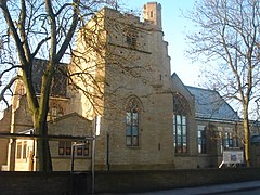
The parish church in Atherton built a mission church at Swan Island in 1873. Hindsford became an independent parish in 1884 and in 1889 the foundation stone for St Anne's Church was laid. The church was completed in 1901 and cost £9,000. [4]

See also

Related Research Articles

Atherton, Greater Manchester Town within the Metropolitan Borough of Wigan, England

Atherton is a town in the Metropolitan Borough of Wigan, in Greater Manchester, England and historically a part of Lancashire. The town, including Hindsford, Howe Bridge and Hag Fold, is 5 miles (8.0 km) east of Wigan, 2 miles (3.2 km) north of Leigh, and 10+34 miles (17.3 km) northwest of Manchester. From the 17th century, for about 300 years, Atherton was known as Chowbent, which was frequently shortened to Bent, the town's old nickname.

Astley, Greater Manchester Human settlement in England

Astley is a village in the Metropolitan Borough of Wigan, Greater Manchester, England. Within the boundaries of the historic county of Lancashire, it is crossed by the Bridgewater Canal and the A580 East Lancashire Road. Continuous with Tyldesley, it is equidistant from Wigan and Manchester, both 8.3 miles (13.4 km) away. Astley Mosley Common ward had a population of 11,270 at the 2011 Census.

Tyldesley Human settlement in England

Tyldesley is a town in the Metropolitan Borough of Wigan in Greater Manchester, England. Within the boundaries of the historic county of Lancashire, it is north of Chat Moss near the foothills of the West Pennine Moors, 7.7 miles (12.4 km) southeast of Wigan and 8.9 miles (14.3 km) northwest of Manchester. At the United Kingdom Census 2001, the Tyldesley built-up area, excluding Shakerley, had a population of 16,142.

Mosley Common Human settlement in England

Mosley Common is a suburb of Tyldesley at the far-eastern edge of the Metropolitan Borough of Wigan, in Greater Manchester, England. Historically part of Lancashire, it was anciently a hamlet in the east of the township of Tyldesley cum Shakerley, in the ancient parish of Leigh. The area of Mosley Common in 1747 was 34 acres (14 ha) statute s.

Shakerley Human settlement in England

Shakerley is a suburb of Tyldesley in the Metropolitan Borough of Wigan, Greater Manchester, England. It was anciently a hamlet in the northwest of the township of Tyldesley cum Shakerley, in the ancient parish of Leigh. The boundary between Shakerley and Hindsford is the Hindsford Brook. It remains the boundary between Tyldesley and Atherton. Hyndforth Bridge across the brook, was rebuilt in stone in 1629.

Westleigh, Greater Manchester

Westleigh, a suburb of Leigh, Greater Manchester, England, is one of three ancient townships, Westleigh, Bedford and Pennington, that merged in 1875 to form the town of Leigh.

The Astley and Tyldesley Collieries Company formed in 1900 owned coal mines on the Lancashire Coalfield south of the railway in Astley and Tyldesley, then in the historic county of Lancashire, England. The company became part of Manchester Collieries in 1929 and some of its collieries were nationalised in 1947.

Tyldesley Coal Company was a coal mining company formed in 1870 in Tyldesley, on the Manchester Coalfield in the historic county of Lancashire, England that had its origins in Yew Tree Colliery, the location for a mining disaster that killed 25 men and boys in 1858.

Howe Bridge Human settlement in England

Howe Bridge is a suburb of Atherton, Greater Manchester, England. Historically within Lancashire, it is situated to the south west of Atherton town centre on the B5215, the old turnpike road from Bolton to Leigh. The settlement was built as a model pit village by the owners of Atherton Collieries.

Ramsden's Shakerley Collieries was a coal mining company operating the Nelson and Wellington Pits from the mid 19th century in Shakerley, Tyldesley in the historic county of Lancashire, England.

Bedford, Greater Manchester Suburb of Leigh, Greater Manchester is one of three ancient townships, Bedford, Pennington and Westleigh, that merged in 1875 to form the town of Leigh

Bedford, a suburb of Leigh, Greater Manchester is one of three ancient townships, Bedford, Pennington and Westleigh, that merged in 1875 to form the town of Leigh. Historically, Bedford was in Lancashire.

Bedford Colliery, also known as Wood End Pit, was a coal mine on the Manchester Coalfield in Bedford, Leigh, Lancashire, England. The colliery was owned by John Speakman, who started sinking two shafts on land at Wood End Farm in the northeast part of Bedford, south of the London and North Western Railway's Tyldesley Loopline in about 1874. Speakman's father owned Priestners, Bankfield, and Broadoak collieries in Westleigh. Bedford Colliery remained in the possession of the Speakman family until it was amalgamated with Manchester Collieries in 1929.

Great Boys Colliery

Great Boys Colliery was a coal mine operating on the Manchester Coalfield in the second half of the 19th century in Tyldesley, then in the historic county of Lancashire, England. It was sunk on Great Boys farm, which in 1778 was described as a "messuage with eight Cheshire acres of land" on the north side of Sale Lane west of the Colliers Arms public house. It was owned by William Atkin and sold in 1855 to mineowners, John Fletcher of Bolton and Samuel Scowcroft. By 1869 their partnership was dissolved and the company became John Fletcher and Sons in 1877. Shafts were sunk for a colliery on Pear Tree Farm on the corner of Mort Lane and Sale Lane which appear in the 1867 Mines Lists and became part of Great Boys Colliery. Fletcher and Schofield were granted permission to construct a mineral railway to join the London and North Western Railway's Tyldesley Loopline in 1868 but there is no evidence that it was built. The colliery closed before 1885. The colliery accessed the Brassey mine at about 170 yards and the Six Foot mine at 182 yards. The deeper coal seams were accessed by New Lester Colliery.

Manchester Collieries was a coal mining company with headquarters in Walkden formed from a group of independent companies operating on the Manchester Coalfield in 1929. The Mining Industry Act of 1926 attempted to stem the post-war decline in coal mining and encourage independent companies to merge in order to modernise and better survive the economic conditions of the day. Robert Burrows of the Atherton company Fletcher Burrows proposed a merger of several independent companies operating to the west of Manchester. The merger was agreed and took place in March 1929.

Fletcher, Burrows and Company was a coal mining company that owned collieries and cotton mills in Atherton, Greater Manchester, England. Gibfield, Howe Bridge and Chanters collieries exploited the coal mines (seams) of the middle coal measures in the Manchester Coalfield. The Fletchers built company housing at Hindsford and a model village at Howe Bridge which included pithead baths and a social club for its workers. The company became part of Manchester Collieries in 1929. The collieries were nationalised in 1947 becoming part of the National Coal Board.

Chanters Colliery was a coal mine which was part of the Fletcher, Burrows and Company's collieries at Hindsford in Atherton, Greater Manchester, then in the historic county of Lancashire, England.

St Annes Church, Hindsford Church in Greater Manchester, England

St Anne's Church is a redundant Anglican parish church in Tyldesley Road, Hindsford, Atherton, Greater Manchester, England. It is recorded in the National Heritage List for England as a designated Grade II listed building.

James Burton was born in Clitheroe in 1784 and owned several cotton mills in Tyldesley and Hindsford in the middle of the 19th century.

Sacred Heart Roman Catholic Church, Hindsford

Sacred Heart Church is a Grade II listed redundant Roman Catholic church on Tyldesley Road, Hindsford, Atherton in Greater Manchester, England. It has been designated by English Heritage as a Grade II listed building.

References

Citations

Bibliography

  • Lunn, John (1971), Atherton Lancashire, A manorial social and industrial history, Atherton UDC
  • Godfrey, Alan (2003), Old Ordnance Survey Maps, Tyldesley & Atherton (SE) 1905, Alan Godfrey Maps, ISBN   1-84151-593-0