Related Research Articles

Combe Raleigh is a village and civil parish in the county of Devon, England. The village lies about 1.5 miles north of the town of Honiton, and the parish is surrounded, clockwise from the north, by the parishes of Luppitt, Honiton, Awliscombe and Dunkeswell.

The Wayfarer's Walk is a 71 mile long distance footpath in England from Walbury Hill, Berkshire to Emsworth, Hampshire.
Eype Mouth is a natural break in a line of sea cliffs on the Jurassic Coast World Heritage Site in west Dorset on the south coast of England. The small River Eype drains into the sea at this point. Eype means 'a steep place' in Old English. The village of Eype lies just upstream of the rivermouth, which is reached by a single narrow lane which runs down through Lower Eype to a shingle beach with car park.

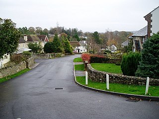
Hinton is a village in South Gloucestershire, England. It is one mile north of Dyrham and forms part of the civil parish of Dyrham and Hinton. The Bull is the local pub.
All Saints is a civil parish in East Devon, Devon, England. It has a population of 498 according to the 2001 census. The parish includes the hamlets of All Saints, Smallridge, Churchill, Alston and Waggs Plot. This area also has one cricket pitch, a primary school, pre-school and a church.

Broadwoodkelly is a village and civil parish in the West Devon district of Devon, England. According to the 2001 census it had a population of 218. The village is situated about 9 miles (14 km) north of Okehampton.

Buckland in the Moor is a village and civil parish in the Teignbridge district of Devon, England. According to the 2001 census it had a population of 94. The village is in Dartmoor.

Bartley Water is a two-branch small river in the New Forest district of Hampshire, England. It drains the north and north-east of the New Forest National Park up to the A31 road, a watershed and two villages against the north-east side of the park.

The River Croco is a small river in Cheshire in England. It starts as lowland field drainage west of Congleton, flows along the south edge of Holmes Chapel, and joins the River Dane at Middlewich. It is about 8 miles (13 km) long.

Bat's Head is a chalk headland on the Dorset coast in southern England. It is located between Swyre Head and Durdle Door to the east, and Chaldon Hill and White Nothe to the west. At the base of the headland is the small Bat's Cave.

Frogmore is a village in the civil parish of Frogmore and Sherford in the South Hams district of the county of Devon, England.
Maybush is a district in the city of Southampton, England. Located in the western side of the city, Maybush is the former location of the Ordnance Survey head office and approximately occupies the SU3814 kilometre square. It is in the Southampton Test parliamentary constituency.
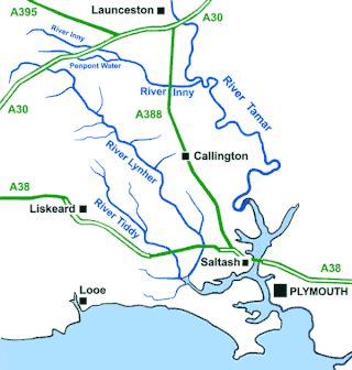
The River Inny is a small river in East Cornwall, England, United Kingdom. A tributary of the River Tamar, the Inny is about twenty miles (32 km) long from its source near Davidstow on the eastern flank of Bodmin Moor to its confluence with the Tamar at Inny Foot near Dunterton.

Weston Mouth is an isolated beach on the East Devon coast between Sidmouth and Seaton in England. It can be reached only by footpath, either along the South West Coast Path or from the village of Weston. The beach is mostly shingle with some sand at low tide, and has no facilities.

The De Lank River is a small river in north Cornwall, England. It is a tributary of the River Camel and is approximately nine miles (14.5 km) long from its source on Bodmin Moor to its confluence with the Camel two miles (3 km) south of St Breward.

Churchbridge is a hamlet in Cornwall, England. It is a mile west of Duloe, and is situated on the West Looe River. Both banks of the river are wooded, and to the north of the bridge is a disused quarry and Tremadart Mills, marked as a corn mill on the 1882 map.
Penelewey is a hamlet southeast of Playing Place in Cornwall, England, UK. Penelewey is on the B3289 road.
Pengegon is a residential area east of Camborne, Cornwall, England, which has a fish and chip shop, a playground and memorial to local teen Shakira Pellow. From 2013 to 2021, Pengegon was included in the Camborne Treslothan division on Cornwall Council. After boundary changes at the 2021 local elections, it was placed in the new Four Lanes, Beacon and Troon division.
Penpont is a hamlet in the parish of St Breward, in north Cornwall, England, UK, in the Camel Valley.

The River Lerryn is a river in east Cornwall, England, UK, a tributary of the River Fowey. The Lerryn is the largest of the tributaries which enter the estuary of the Fowey. The river is tidal up to the village of Lerryn. The landscape of the Lerryn catchment is rural and includes heathland, moorland and rough pasture in the upper reaches and broadleaf, coniferous and mixed plantation woodland in the lower. This catchment includes four SSSIs, including Redlake Meadows & Hoggs Moor. The Lerryn rises at Fairy Cross on the southern slopes of Bodmin Moor and flows south-southwest until it enters the Fowey estuary.
References
- ↑ Ordnance Survey: Landranger map sheet 196 The Solent & Isle of Wight (Southampton & Portsmouth) (Map). Ordnance Survey. 2015. ISBN 9780319231425.
50°55′19″N1°02′02″W / 50.922°N 1.034°W
| | This Hampshire location article is a stub. You can help Wikipedia by expanding it. |