The river derives its name from the Sri Hiranyakeshi temple. The temple is built over caves from where the river originates as a fresh mountain stream.[2][3] Hiranyakeshi is a Sanskrit word which means "one with golden hair"[4] and refers to the Hindu goddess Parvati.[citation needed]
Course
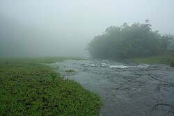
Sri Hiranyakeshi temple
The river begins in the caves in Hiranyakeshwar temple near the hill station of Amboli. It flows northwest towards Jakatwadi, a small village next to Amboli, where it turns right almost at a right angle and begins to flow east. It flows underneath a bridge supporting state highway 121, which the British named Victoria Jubilee Bridge[5] and goes northeast to the town of Ajra in the Kolhapur district of Maharashtra.
2km before it reaches Ajra, the river plunges over a rocky ledge about 5 metres high forming the Ramteerth falls and then crosses under another bridge. It continues its run now along the right side of SH 134 crossing over into the Belgaum district, Karnataka. At the town of Sankeshwar it goes southeast for a short distance before it converges with Ghataprabha river after Hidkal dam and before Gokak falls.
Ramteerth falls at Ajra
Irrigation
Two barriers constructed over the river, known as the Dabhil weir and the Devarde weir, provide irrigation water to the neighbouring villages.[6]
Ecology
Malabar melastome grows along the banks of the river.
The area around the river's origin being a sacred groove is protected by the locals.[citation needed] During the monsoon months, fresh rain water transforms the landscape into a lush green oasis with different types of mushrooms which sprout out along its banks.[citation needed] There are also a variety of plants like karvi and malabar melastome.[citation needed]
Water pollution status
Physico-chemical analysis showed that the water of the Hiranyakeshi River was in 2010 mostly within the limits of WHO standards with the exemption of samples taken at Chicalgud because of the addition of domestic sewage and sugar mill effluents.[citation needed]
This page is based on this Wikipedia article Text is available under the CC BY-SA 4.0 license; additional terms may apply. Images, videos and audio are available under their respective licenses.