History of high-capacity transit in Spokane, Washington

Last updated

Early 2000s light rail proposal

In 2000, the boards of Spokane Transit Authority and Spokane Regional Transportation Council established a steering committee, formally known as the Light Rail Steering Committee, to evaluate a high-capacity transit route between Downtown Spokane and Liberty Lake [1] to serve the growing I-90 corridor through the Spokane metropolitan area.

Contents

Vision

The vision for a regional light rail system consisted of a line that would serve urban development along the east-west I-90 corridor, connecting Spokane to Coeur d'Alene, Idaho, and a second line serving North Spokane. [2]

Early efforts focused on developing an initial line from Downtown Spokane to Liberty Lake. Future extensions would length the line west to Spokane International Airport and east to Coeur d'Alene, Idaho. A future line serving North Spokane would largely run along the North Spokane Corridor, which was originally designed to accommodate a high-capacity transit line (such as light rail) in its median. [3]

Final recommendation

Culminating six years of study, the Light Rail Steering Committee made a final recommendation to the STA and SRTC of vehicle type and alignment. The final recommendation called for the light rail to run along a 15.5-mile alignment from Downtown Spokane to Liberty Lake, with 14 stations. As part of an effort to contain costs, the system would utilize diesel multiple unit light rail train sets (eliminating the need for overhead electric infrastructure), and its alignment would largely consist of a single, bi-directional shared track, with areas of a second passing track. [4] [5]

Stations

The proposed light rail line would have consisted of 14 stations, [6] 7 of which would have included park and rides:

List of proposed Spokane–Liberty Lake Light Rail stations
StationLocationNotes
STA Plaza Riverside Avenue, between Post Street and Wall StreetWestern Terminus
Convention CenterRiverside Avenue, between Bernard Street and Browne StreetStretch of roadway now hosts the westbound Riverside & Bernard City Line station
Riverpoint (Trent)On undeveloped land north of BNSF railway tracks on WSU Spokane campusServing the Riverpoint Higher Education Park and University District
NapaRiverside Avenue, just east of Napa Street
East CentralOn undeveloped land in the Union Pacific Railroad right of way, just east of Freya Street
FairgroundsSouth side of Spokane County Fair and Expo Center siteProposed Park and Ride
ParkOn undeveloped land in Union PacificOption to construct as a future infill station
ArgonneIntersection of Argonne Road and Appleway BoulevardProposed Park and Ride
University CityAdjacent to Pence-Cole Valley Transit Center Shared park and ride facility with existing transit center
PinesOn undeveloped land in abandoned railroad right of way at intersection east of Pines RoadProposed Park and Ride
EvergreenOn undeveloped land in abandoned railroad right of way at intersection east of Evergreen Road
SullivanOn undeveloped land in abandoned railroad right of way at intersection with Sullivan RoadProposed Park and Ride
ApplewayOn undeveloped land near I-90/Appleway interchangeProposed Park and Ride
Liberty LakeAdjacent to existing STA Liberty Lake Park and RideEastern Terminus, shared park and ride facility, with option to redevelop existing park and ride

Public vote

In August 2006, following the final project recommendations of the Light Rail Steering Committee, the Spokane Transit Authority Board approved two advisory questions to appear in November 2006 general election ballots. The first question would inquire voters about tasking STA to develop a funding plan for the project. The second question would ask voters if STA should use an existing $5 million worth of funds to start preliminary engineering work. The advisory questions would be used by STA to gauge the community's desire to continue to develop the project. [7]

Both advisory measures were defeated by voters. The first question regarding development of a funding plan failed 54% to 46%, and the vote using existing funds to continu with preliminary engineering, design and environmental analysis lost, albeit by a narrow margin, 52% to 48%. [8]

Going into the election, it was felt that the defeat of both advisory questions would put a pause to the project. [7]

Subsequent actions and efforts

The Light Rail Steering Committee was officially disbanded in December 2016, just one month after Spokane County voters turned down two advisory votes to advance the proposed light rail project. [9]

In an effort to leave open the possibility of revisiting the light rail proposal in the future, the STA Board voted to approve $5 million to help support right of way acquisition along the route's proposed alignment. [9]

Downtown Spokane streetcar

Rail-based urban transportation had historically been a part of Spokane's development in the early 20th century, with numerous streetcars and trolleys running through the city's core. However, as the automobile gained in popularity throughout the century, the streetcars and their tracks were eventually phased out in favor of buses. [10]

In 1999, a revival of rail transit in Spokane was discussed, with vision documents in Spokane's Downtown Plan [11] calling for the development of a modern streetcar line in Downtown Spokane. By the early 2000s, Local leaders in Spokane, representing three the Downtown Spokane Partnership, Spokane Regional Transportation Council, and Spokane Transit Authority partnered to study the feasibility of implementing a fixed-rail streetcar system in Downtown Spokane. Citing benefits from the Portland Streetcar, which opened in 2001, leaders were drawn the potential for the project to spur investment and development in Downtown Spokane. [12]

Vision

In 2005, the vision to develop a streetcar line was officially adopted as a project by Spokane Transit Authority [11] and the agency commissioned a streetcar feasibility study in partnership with other local transportation and planning agencies. The report, titled Spokane Streetcar Feasibility Study, was released in March 2006 and studied a number of topics related to installing a streetcar line in Spokane, including potential routes, alignments, vehicles, costs, and urban development potential. [13]

Alignments would have run primarily within the right of way on existing streets through Spokane, providing easy customer access and having little impact on curbside downtown parking. [12]

Alignment alternatives

The geography of Downtown Spokane and its surrounding areas is bisected by the Spokane River, with major destinations and points of interest on either side of it. With limited opportunities for a streetcar to cross the river and connect these destinations, the feasibility study proposed a strategy that utilized multiple streetcar lines to move people between these destinations. Separate lines would serve key areas north of the river, such as the Spokane County Government Center and the Spokane Arena, and areas south of the river such as the Browne's Addition neighborhood, Downtown Core, and University District. [12] To facilitate transfers, the two lines would intersect and cross over one another in Downtown Spokane. [13]

Visualizations of the streetcar's alignment were included in the feasibility study, several of which highlighted the never-built northern line and its transformative presence through Riverfront Park and along Mallon Avenue in front of the Spokane Veterans Memorial Arena. [13]

A total of five alignment alternatives were developed as part of the study and focused on serving neighborhoods and areas within the immediate vicinity of the Downtown Spokane core, including Browne's Addition to the west; North Bank, Spokane County government campus, and Kendall Yards to the north; University District to the east, and Medical District to the south:

  • Alignment Alternative A was known as the Downtown Plan. It consisted of three separate lines, one running north–south through Downtown Spokane from the North Bank neighborhood to the Lower South Hill and Medical District. It would intersect two lines running west–east across the city. One of these intersecting lines would run along the north bank of the Spokane River, from Kendall Yards, through the Spokane County government campus, past the Spokane Arena, and onward to Gonzaga University. The other west–east line would run south of the Spokane River, from Browne's Addition, through the Downtown Spokane core, and onward into the University District. [13]
  • Alignment Alternative B was known as The Basic. It was a simplified two-line version of Alternative A, eliminating the west–east line that along the north bank of the Spokane River between Kendall Yards and Gonzaga University. It maintained the north–south line in Alternative A, but extended the southern west–east line to serve Gonzaga. [13]
  • Alignment Alternative C was known as Basic-Expanded. Based on Alternative B, the proposed routing take the proposed northern-terminus in the North Bank neighborhood and move it west into Kendall Yards. The result would be a simplified two-line system that would still serve every destination covered in Alignment Alternative A. [13]
  • Alignment Alternative D was known as West-East. This two-line alternative was based on Alternative Alignment C, but instead of a mere intersection of the two lines in the Downtown Core, both lines would overlap one another and operate on a common east–west roadway through the Downtown Spokane core. This arrangement would allow for greater transfer opportunities between the two lines as well as the benefit of providing direct service to any of the four end-of-line termini from Downtown Spokane without needing to make a transfer. [13]
  • Alignment Alternative E was known as Loop-Plus. The fifth proposed alignment utilized a single line that operated in a loop pattern. The route would begin in Kendall Yards, running through the Spokane County government campus, pass by the Spokane Arena and turn south to the Downtown Core through Riverfront Park. From the Downtown Core, it would proceed south through the Medical District, loop back north through the University District and turn west back through the Downtown Core, intersecting its aforementioned north–south leg, and continue onward to its terminus in Browne's Addition. While the alternative presented the simplicity of only operating a single line, several disadvantages were identified including the length of the line, the lack of direct service to Gonzaga University, and the need to cross the line over Interstate 90 and BNSF railroad track. [13]

Spokane's streetcar feasibility study evolved into Spokane's first bus rapid transit line, City Line.

Bus rapid transit

City Line

Spokane Transit City Line - Bus left side - 2023 0715.jpg

Outcomes of the Spokane Streetcar Feasibility Study were adopted into a project in 2011, with a working title of the Central City Line. A preliminary alignment would run from Browne's Addition, through the Downtown Core, to the University District, with a proposed extension continuing further east to Spokane Community College. [11]

The mode of transportation for the Central City Line evolved from the feasibility study's fixed-rail streetcar into a lower-cost trolleybus. However, despite the change in vehicle type, local business community maintained that the vehicles needed to electric and appear streetcar and train-like. Inspired by aesthetic appeal of trolley buses in Europe, early visions for the project called for utilizing a modern trolley bus in order to differentiate the project from traditional-looking North American trolleybuses. [11]

Further evolutions to the project resulted in the Central City Line ultimately becoming a bus rapid transit line utilizing battery-electric buses.

City Line opened on July 15, 2023, as the region's first bus rapid transit line.

Division Bus Rapid Transit

Spokane Transit Authority has begun work on the region's second bus rapid transit line, to be operated on Division Street from Downtown Spokane to the northern areas of Spokane.

Related Research Articles

<span class="mw-page-title-main">Spokane Transit Authority</span> Public transit authority

Spokane Transit Authority, more commonly Spokane Transit or STA, is the public transport authority of central Spokane County, Washington, United States, serving Spokane, Washington, and its surrounding urban areas. In 2022, the system had a ridership of 6,995,300, or about 28,900 per weekday as of the first quarter of 2023.

<span class="mw-page-title-main">North–South Rail Link</span> Proposed rail tunnel connecting Bostons North and South Stations

The North–South Rail Link (NSRL) is a proposed rail tunnel, or pair of tunnels, that would connect North Station and South Station in downtown Boston, Massachusetts. The project would build new underground stations near the existing stations, connect them with about 1.5 miles (2.4 km) of tunnels, and add other tunnels to link up with existing surface tracks.

<span class="mw-page-title-main">San Diego Trolley</span> Light rail system serving San Diego, California

The San Diego Trolley is a light rail system operating in the metropolitan area of San Diego. It is known colloquially as "The Trolley". The Trolley's operator, San Diego Trolley, Inc. (SDTI), is a subsidiary of the San Diego Metropolitan Transit System (MTS). The Trolley began service on July 26, 1981, making it the oldest of the second-generation light rail systems in the United States. The Trolley system serves 62 stations, comprises 65 miles (105 km) of route, three primary lines that operate daily, and one heritage line that operates on a circuit of downtown on select days. In 2022, the Trolley had the fifth highest ridership of light rail systems in the United States, with 34,053,400 annual rides, or about 109,500 per weekday as of the first quarter of 2023.

The Urban Ring was a proposed project of the Massachusetts Bay Transportation Authority and the Massachusetts Department of Transportation, to develop new public transportation routes that would provide improved circumferential connections among many existing transit lines that project radially from downtown Boston. The Urban Ring Corridor is located roughly one to two miles from downtown Boston, passing through the Massachusetts cities of Boston, Chelsea, Everett, Medford, Somerville, Cambridge, and Brookline. The project was expected to convert 41,500 car trips to transit trips daily.

<span class="mw-page-title-main">MAX Green Line</span> Light rail line in Portland, Oregon

The MAX Green Line is a light rail service in Portland, Oregon, United States, operated by TriMet as part of the MAX Light Rail system. It is 15 miles (24.1 km) long and serves 30 stations from the PSU South stations to Clackamas Town Center Transit Center; it connects Portland State University (PSU), Portland City Center, Northeast Portland, Southeast Portland, and Clackamas. The Green Line is the only service that shares parts of its route with the four other MAX services, sharing the Portland Transit Mall with the Orange and Yellow lines and the Banfield segment of the Eastside MAX with the Blue and Red lines. Southbound from Gateway/Northeast 99th Avenue Transit Center, it operates the Interstate 205 (I-205) segment through to Clackamas Town Center. Service runs for approximately 2112 hours daily with a headway of 15 minutes during most of the day. It is the third-busiest line in the system, carrying an average of 19,160 riders per day on weekdays in September 2019.

<span class="mw-page-title-main">Red Line (Baltimore)</span> Proposed mass transit light rail line

The Red Line is a proposed east–west transit line for Baltimore, Maryland. The project was granted federal approval to enter the preliminary engineering phase and the Maryland Transit Administration had spent roughly $300 million in planning, design and land acquisition, until Maryland Governor Larry Hogan declared on June 25, 2015 that he would not provide state funds for the project, instead shifting $736 million of state funding to roads in suburban areas. The Red Line had been projected to cost roughly $1.6 billion, $900 million of which would have been guaranteed federal funding.

The Chicago Central Area Transit Plan, generally referred to as the Chicago Central Area Transit Project (CCATP) in the 1970s, was an extensive study of the rapid transit system in downtown Chicago; the study had begun in 1965.

The Bottineau LRT is a proposed light rail line extension in the Minneapolis – Saint Paul Metro area, projected to run northwest from Target Field station in downtown Minneapolis along County Road 81 to Brooklyn Park.

<span class="mw-page-title-main">Streetcars in Atlanta</span> Aspect of the history of Atlanta, Georgia, USA

Streetcars originally operated in Atlanta downtown and into the surrounding areas from 1871 until the final line's closure in 1949.

<span class="mw-page-title-main">DART Light Rail</span> Light rail system in the Dallas-Fort Worth Metroplex

DART Light Rail is the light rail system serving the metropolitan area of Dallas, Texas and is owned and operated by Dallas Area Rapid Transit (DART). The DART Light Rail system opened June 14, 1996 and serves 65 stations and four lines, covering 93 miles (149.7 km): the Red Line, the Blue Line, the Green Line, and the Orange Line.

<span class="mw-page-title-main">Silver Line (San Diego Trolley)</span> San Diego Trolley Heritage line

The Silver Line is a 2.7-mile (4.3 km) heritage streetcar line operated by the San Diego Trolley, an operating division of the San Diego Metropolitan Transit System. It currently operates the "downtown loop"; a circle of tracks around Downtown San Diego, and is operated using renovated historic vehicles. The line is one of four lines in the Trolley system; the others include the Blue, Orange, and Green lines.

<span class="mw-page-title-main">Metro (Minnesota)</span> Rapid transit network in the Minneapolis metropolitan area of the United States

Metro is a transit network in Minnesota serving the cities of Minneapolis and Saint Paul. It also provides service to some suburban areas. As of 2022 the system consists of two light rail lines and five bus rapid transit (BRT) lines all of which are operated by the local public transit company: Metro Transit. The five lines connect Downtown Minneapolis and St Paul with the Bloomington, Minneapolis-St Paul International Airport, Roseville, Richfield, Burnsville and Brooklyn Center.

Streetcars were the primary mode of public transport in Tacoma, Washington, United States from the late 1800s until their discontinuance in 1938. Operated together with a network of interurbans, streetcars provided transport within Tacoma and throughout the Puget Sound region. Buses replaced the last streetcars in 1938. Streetcar-type transportation returned to Tacoma in 2003 with the opening of the Tacoma Link, a 1.6-mile (2.6 km) light rail line in Downtown Tacoma. There are proposals both to expand this system and to construct a new heritage streetcar system.

<span class="mw-page-title-main">O-Train</span> Rapid transit system in Ottawa, Ontario

The O-Train is a light metro transit system in Ottawa, Ontario, Canada, operated by OC Transpo. The O-Train system has two lines, the electrically-operated Confederation Line and the diesel-operated Trillium Line. Since May 2020, Stage 2 construction has temporarily shut down Line 2, with replacement bus service being offered at all stations. When Line 2 reopens in late 2023, it will extend southward to Limebank station and incorporate five newly constructed stations, as well as an additional line linking Line 2 to Ottawa International Airport which will replace the current bus service from route 97. By 2026, expansions along Line 1 and the construction of Line 3 stations in the west end are expected to be complete, bringing the system's length to 64.5 km (40.1 mi), four lines and 41 stations. The O-Train network is fully grade separated and does not have any level crossings with roads.

<span class="mw-page-title-main">OC Streetcar</span> Under construction light rail line in Orange County, California

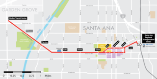
The OC Streetcar is a modern streetcar (LRT) line currently under construction in Orange County, California, running through the cities of Santa Ana and Garden Grove. The electric-powered streetcar will be operated by the Orange County Transportation Authority (OCTA), and will serve ten stops in each direction along its 4.15-mile (6.68 km) route. With the exception of a short loop in downtown Santa Ana, the line will be double-tracked for its entire length. Most of the route follows the original path of the Pacific Electric Railway "Red Cars" that served Santa Ana in the early 20th century, before being abandoned in 1950. Construction on the streetcar broke ground on November 30, 2018, and the line expected to open to the public in 2024.

<span class="mw-page-title-main">City Line (Spokane, Washington)</span> Bus rapid transit line in Spokane, Washington, United States

The City Line is a bus rapid transit (BRT) line in Spokane, Washington, United States, that opened on July 15, 2023. The 6-mile-long (9.7 km) route, which is operated by the Spokane Transit Authority, runs from Spokane's Browne's Addition neighborhood, through Downtown Spokane and the University District, including the WSU Health Sciences campus and Gonzaga University, before ending at the Spokane Community College campus in the Chief Garry Park neighborhood. The project budget as of 2023 was $92.2 million.

Pence-Cole Valley Transit Center is a transit center and former proposed site of a light rail station in the Spokane Transit Authority route system. It is one of Spokane Transit's three primary transit centers, along with the Spokane Community College and STA Plaza, and is the main transit hub for Spokane Valley.

The West Santa Ana Branch Transit Corridor is a planned light rail line, mostly following the Pacific Electric's historic West Santa Ana Branch, connecting Downtown Los Angeles to the city of Artesia, along with other cities in southeastern Los Angeles County.

The history of the Los Angeles Metro Rail and Busway system begins in the early 1970s, when the traffic-choked region began planning a rapid transit system. The first dedicated busway opened along I-10 in 1973, and the region's first light rail line, the Blue Line opened in 1990. Today the system includes over 160 miles (260 km) of heavy rail, light rail, and bus rapid transit lines, with multiple new lines under construction as of 2019.

<span class="mw-page-title-main">Division Bus Rapid Transit (Spokane, Washington)</span> Under-development bus rapid transit line in Spokane, Washington, United States

Division Bus Rapid Transit, also known as Division BRT, is the working name for a planned bus rapid transit line in Spokane, Washington that will extend 9 miles from Downtown Spokane to the Mead, Washington area, north of Spokane. The line will be operated by Spokane Transit Authority, with a planned launch in 2027, and will be the region's second bus rapid transit line, after the City Line.

References

  1. Traver, K.C. (March 27, 2010). "Light rail spurs local economy". The Spokesman-Review. Retrieved 13 August 2023.
  2. "Spokane Regional Light Rail" (PDF). The Inland Empire Rail Transit Association. Retrieved 13 August 2023.
  3. "The North Spokane Corridor: Moving Ahead". Greater Spokane Incorporated. Retrieved 13 August 2023.
  4. "Recommended Option". Spokane Light Rail. Retrieved August 13, 2023.
  5. "Steering committee recommends light rail system for Spokane". KHQ. April 6, 2006. Retrieved 13 August 2023.
  6. "Preferred Alternative Alignment Characteristics" (PDF). Inland Rail. Retrieved 13 August 2023.
  7. 1 2 Cannata, Amy (August 18, 2006). "Light rail or no? Voters to get a say". The Spokesman-Review. Retrieved 13 August 2023.
  8. McDermott, Ted (August 16, 2021). "Getting There: Can Spokane's light rail effort be revived?". The Spokesman-Review. Retrieved 13 August 2023.
  9. 1 2 Cannata, Amy (December 15, 2006). "STA sets aside light rail proposal". The Spokesman-Review. Retrieved 13 August 2023.
  10. Kershner, Jim (January 25, 2007). "Spokane's Streetcars". Essay 8080. HistoryLink. Retrieved December 7, 2014.
  11. 1 2 3 4 Walters, Daniel (September 24, 2013). "Streetcar desired". Inlander. Retrieved May 2, 2020.
  12. 1 2 3 "Fixed-rail streetcars mulled". Spokane Journal of Business. September 5, 2003. Retrieved August 13, 2023.
  13. 1 2 3 4 5 6 7 8 "Spokane Streetcar Feasibility Study" (PDF). URS Corporation. Retrieved May 2, 2020.