The Districts of Ghana are second-level administrative subdivisions of Ghana, below the level of region. There are currently 261 local metropolitan, municipal and district assemblies.

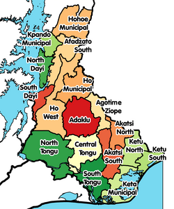
Volta Region is one of Ghana's sixteen administrative regions, with Ho designated as its capital. It is located west of Republic of Togo and to the east of Lake Volta. Divided into 25 administrative districts, the region is multi-ethnic and multilingual, including groups such as the Ewe, the Guan, and the Akan peoples. The Guan peoples include the Lolobi, Likpe, Akpafu, Akyode, Buem, Nyagbo, Avatime, and Nkonya. This region was carved out of the Volta Region in December 2018 by the New Patriotic Party. The people of the Volta Region are popularly known as Voltarians. This group includes the Ewes, Guans and other minor tribes living in the Volta Region. The people of the Volta Region are popular known for their rich cultural display and music some of which include Agbadza, Borborbor and Zigi.

Akatsi District is a former district that was located in Volta Region, Ghana. Originally created as an ordinary district assembly on 10 March 1989, which was created from the former Anlo District Council. However, on 28 June 2012, it was split off into two new districts: Akatsi South District and Akatsi North District. The district assembly was located in the southeast part of Volta Region and had Akatsi as its capital town.

Kpando Municipal District is one of the eighteen districts in Volta Region, Ghana. Originally created as an ordinary district assembly on 10 March 1989 when it was known as Kpando District, until the southern part of the district was split off by a decree of president John Agyekum Kufuor on 19 August 2004 to create South Dayi District; thus the remaining part has been retained as Kpando District. However on 28 June 2012, the southern part of the district was later split off to create North Dayi District on 28 June 2012; while the remaining part was elevated to municipal district assembly status on the same year to become Kpando Municipal District. The municipality is located in the western part of Volta Region and has Kpando as its capital town.
North Tongu District is one of the eighteen districts in Volta Region, Ghana. Originally it was formerly part of the then-larger and original North Tongu District on 10 March 1989, with Adidome as its capital town, which was created from the former Tongu District Council, until the western part of the district was split off to create a new North Tongu District on 28 June 2012, with Battor Dugame as its capital town, which was established by Legislative Instrument (L.I.) 2081; thus the remaining part has been renamed as Central Tongu District, with Adidome as its capital town, which was established by Legislative Instrument (L.I.) 2077. The district assembly is located in Addidome, near Adidome Senior High School (Adisec) the southwest part of Volta Region and has Battor Dugame as its capital town.

West Gonja Municipal Assembly is one of the seven districts in Savannah Region, Ghana. Originally created as an ordinary district assembly on 23 December 1988 when it was known as West Gonja District, until the southern part of the district was split off by a decree of president John Agyekum Kufuor in August 2004 to create Central Gonja District; thus the remaining part was retained as West Gonja District. However, on 6 February 2012, the northern part of the district was later split off to create North Gonja District; thus the remaining part has been retained as West Gonja District. Later, it was elevated to municipal district assembly status on 27 January 2020 to become West Gonja Municipal District. The municipality is located in the central part of Savannah Region and has Damongo as its capital town.

Ho West is one of the constituencies represented in the Parliament of Ghana. It elects one Member of Parliament (MP) by the first past the post system of election. Ho West is located is in the Ho West District of the Volta Region of Ghana. Its capital is Dzolokpuita.
Adidome is a small town and is the capital of Central Tongu district, a district in the Volta Region of Ghana. According to the Ghana Statistical Service 2010 Population and Housing Census, the population of Adidome was 7,587. The distance from Adidome to Ghana's capital, Accra is approximately 144 km. The town has a Senior High School called Adidome Senior High School. Adidome is not only noted for its Senior High School but also the Adidome Farm Institute.

Ga West Municipal Assembly is one of the twenty-nine districts in Greater Accra Region, Ghana. Originally it was formerly part of the then-larger Ga District in 1988, until the eastern part of the district was split off to create Ga East District in 2004; thus the remaining part has been renamed as Ga West District. Later, the western part of the district was split off to create the first Ga South Municipal Assembly on 29 February 2008, with Weija as its capital town; while Ga West was later elevated to municipal district assembly status during that same year to become Ga West Municipal District. However on 15 March 2018, the eastern part of the district has split off to create Ga North Municipal Assembly, thus the remaining part has been retained as Ga West Municipal Assembly. The municipality is located in the western part of Greater Accra Region and has Amasaman as its capital town.
Ho Municipal Assembly is one of the 25 administrative Districts in the Volta Region, Ghana. It is made up of total land size of 2,361 km2 and a total estimated population of 213,960 in 2017, 105,195 being males and 108,765 are females. Originally created as an ordinary district assembly on 10 March 1989 when it was known as Ho District, until the southern part of the district was split off by a decree of president John Agyekum Kufuor on 13 August 2004 to create Adaklu-Anyigbe District; thus the remaining part has been retained as Ho District. However on 28 June 2012, the western part of the district was later split off to create Ho West District; thus the remaining part was elevated to municipal district assembly status on that same year to become Ho Municipal Assembly, which was established by Legislative Instrument (L.I.) 2074. The municipality is located in the central part of Volta Region and has Ho as its capital town.
Afadzato South District is one of the eighteen districts in Volta Region, Ghana. Originally it was formerly part of the then-larger Hohoe District on 10 March 1989, until the southern part of the district was split off to create Afadzato South District on 28 June 2012; thus the remaining portion has been retained as Hohoe Municipal District. The district assembly is located in the northern part of Volta Region and has Ve Golokwati as its capital town.
La Dade Kotopon Municipal Assembly is one of the twenty-nine districts in Greater Accra Region, Ghana. Originally it was formerly part of the then-larger Accra Metropolitan Assembly in 1988, until the eastern portion of the district was split off to create La Dade Kotopon Municipal Assembly on 28 June 2012; thus the remaining part has been retained as Accra Metropolitan Assembly. The municipality is located in the central part of Greater Accra Region and has La as its capital town.
Ada East District is one of the twenty-nine districts in Greater Accra Region, Ghana. Originally it was formerly the part of the then-larger Dangme East District in 1988, which was created from the former Dangme District Council, until the western part of the district was split off to create Ada West District on 28 June 2012; thus the remaining part has been renamed as Ada East District. The district assembly is located in the eastern part of Greater Accra Region and has Ada Foah as its capital town.
Ada West District is one of the twenty-nine districts in Greater Accra Region, Ghana. Originally it was formerly part of the then-larger Dangme East District in 1988, which was created from the former Dangme District Council, until the western part of the district was split off to create Ada West District on 28 June 2012; thus the remaining part has been renamed as Ada East District. The district assembly is located in the eastern part of Greater Accra Region and has Sege as its capital town.
Ningo Prampram District is one of the twenty-nine districts in Greater Accra Region, Ghana. Originally it was formerly part of the then-larger Dangme West District in 1988, which was created from the former Dangme District Council, until the southern part of the district was split off to create Ningo-Prampram District on 28 June 2012; thus the remaining part has been renamed as Shai-Osudoku District. The district assembly is located in the eastern part of Greater Accra Region and has Prampram as its capital town.
La Nkwantanang Madina Municipal District is one of the twenty-nine districts in Greater Accra Region, Ghana. Originally it was formerly part of the then-larger Ga East District in 2004, until the eastern part of the district was split off to create La-Nkwantanang-Madina Municipal Assembly on 28 June 2012, which was established by Legislative Instrument (L.I.) 2131; thus the remaining part has been retained as Ga East Municipal Assembly. The municipality is located in the western part of Greater Accra Region and has Madina as its capital town.
Central Tongu District is one of the eighteen districts in Volta Region, Ghana. Originally created as an ordinary district assembly on 10 March 1989 when it was known as the first North Tongu District, with Adidome as its capital town, which was created from the former Tongu District Council, However on 28 June 2012, the western part of the district was split off to create a new North Tongu District, with Battor Dugame as its capital town, which was established by Legislative Instrument (L.I.) 2081; thus the remaining part has been renamed as Central Tongu District, with Adidome as its capital town, which was established by Legislative Instrument (L.I.) 2077. The district assembly is located in the southwest part of Volta Region and has Adidome as its capital town.

Pusiga District is one of the fifteen districts in Upper East Region, Ghana. Originally it was formerly part of the then-larger Bawku Municipal District in 1988; until two parts of the district were later split off to create Binduri District and Pusiga District respectively on 28 June 2012. The district assembly is located in the eastern part of Upper East Region and has Pusiga as its capital town.
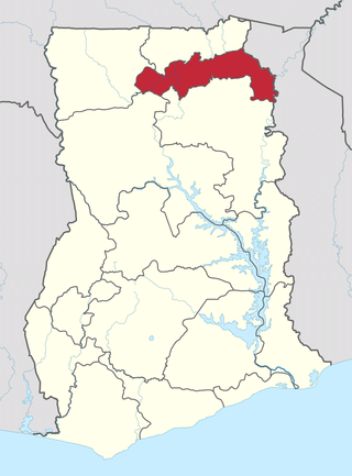
The North East Region is one of the sixteen regions of Ghana. It is located in the north of the country and was created in December 2018 after a referendum was voted upon to break it off of the Northern region. The region's capital is Nalerigu.