Hobson's Conduit

Last updated

Hobson's Conduit as it runs alongside Cambridge University Botanic Garden on Trumpington Road. Hobson'sconduit1.JPG
Hobson's Conduit as it runs alongside Cambridge University Botanic Garden on Trumpington Road.

Hobson's Conduit, also called Hobson's Brook, is a watercourse that was built from 1610 to 1614 by Thomas Hobson and others to bring fresh water into the city of Cambridge, England from springs at Nine Wells, a Local Nature Reserve [1] [2] ( 52°09′58″N0°08′06″E / 52.166°N 0.1349°E / 52.166; 0.1349 (Hobson Conduit (spring at Nine Wells)) ), near the village of Great Shelford. [3] It is now a Scheduled Ancient Monument [4] and historical relic. The watercourse currently runs overground until Cambridge University Botanic Garden and Brookside, where it is at its widest. At the corner of Lensfield Road stands a hexagonal monument to Hobson, which once formed part of the market square fountain, and was moved to this location in 1856, after a fire in the Market. [3] The flow of water runs under Lensfield Road, and subsequently runs along both sides of Trumpington Street in broad gutters towards Peterhouse and St Catharine's College, and also St Andrew's Street. The conduit currently ends at Silver Street.

Contents

The scheme was first devised in 1574 by Andrew Perne, Master of Peterhouse, who proposed that a stream be diverted from Nine Wells chalk springs through the town and the King's Ditch to improve sanitation. The design was revived by James Montagu, Master of Sidney Sussex College and built at the expense of the University and town. [5] Although Thomas Hobson was just one of those involved in the construction he endowed a Hobson's Conduit Trust to deal with maintenance of the waterway, which still exists today. The new river was dug from Vicar's Brook near Long Road to the conduit head at the end of Lensfield Road as a joint venture between the University and the city. Here the flow of water was divided into four separate branches for different uses. [6]

Hobson's Brook from Nine Wells to the conduit head

Portion of an 1886 ordnance survey map showing the overground course of Hobson's Conduit and Vicar's Brook Hobson's-brook-Vicar's-brook=.png
Portion of an 1886 ordnance survey map showing the overground course of Hobson's Conduit and Vicar's Brook

Hobson's Conduit was originally formed by diverting the water from Vicar's Brook. From its source in chalkland springs at Nine Wells, near Great Shelford, this stream flows east of Trumpington under bridges on Long Road and Trumpington Road until reaching Coe Fen, where it forms the first tributary of the River Cam above Cambridge. The man-made channel Hobson's Brook branches off from Vicar's Brook between the two bridges and initially runs parallel to Vicar's Brook, enclosing a stretch of common ground, now used for allotments. A public footpath, formerly known as Finch's or Senior Wrangler's Walk, follows this portion of the watercourse. The stream widens as it skirts the western boundary of the University Botanic Gardens until passing under Bateman Street. In the last portion before the conduit head at Lensfield Road, where it divides into four branches, the channel flows between Brookside and Trumpington Street through gardens enclosed by 19C wrought iron railings. [7]

Trumpington Street branch

The original branch still functions as sluices along Trumpington Street, where it is known as the Pem (east side) and Pot (west side). [8] The City Council's Drainage Engineer controls flow through the sluices and generally lets water flow in the open conduits in Trumpington Street between April and September. Feeds run into Peterhouse and Pembroke Colleges. A run also used to feed into the basement of the old Addenbrooke's Hospital, which became the location of the Judge Institute by 1995. [9]

Market Place branch

1841 engraving showing the original Market fountain Cambridge market place Le Keux 1841.jpg
1841 engraving showing the original Market fountain

Completed in 1614, this branch brought fresh water to the Market fountain in the centre of the Cambridge Market Place. Following a fire in 1849, the Market Square was redeveloped and in 1855 a Gothic Revival gabled fountain was erected (marked on many contemporary maps as "lavatory" as there were underground public conveniences here) and the original fountain was partly moved to form the monument in Lensfield Road, and the remainder demolished. Most of the Victorian fountain was pulled down in 1953.

Flow to this branch was cut off in 1970 during construction of the Lion Yard development and has never been restored. [9]

St Andrew's Street branch

Added in 1631, this branch flowed from the conduit head along Lensfield Road and St Andrew's Street toward Drummer Street where it split into feeds that ran into Christ's and Emmanuel Colleges as well as a public dipping point. Much of the open conduit along St Andrew's Street was covered in 1996 as part of pedestrian improvements. [9]

Parker's Piece branch

A final branch ran from the conduit head toward Parker's Piece to feed a cattle pond, but this was disrupted in 1827 when the pond was filled in.[ citation needed ]

Monuments

There are two monuments, one on Lensfield Road ( 52°11′52″N0°07′21″E / 52.1979°N 0.1224°E / 52.1979; 0.1224 (Lensfield Road) , see picture below) and one at Nine Wells. The latter was erected in 1861 by public subscription and records the benefactors to the water course and conduit as:

Related Research Articles

<span class="mw-page-title-main">Peterhouse, Cambridge</span> College of the University of Cambridge

Peterhouse is the oldest constituent college of the University of Cambridge in England, founded in 1284 by Hugh de Balsham, Bishop of Ely. Peterhouse has around 300 undergraduate and 175 graduate students, and 54 fellows.
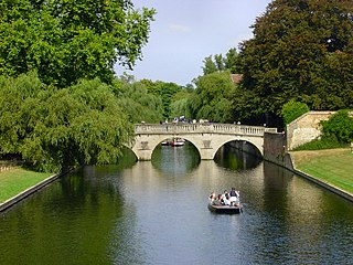
 It is quite often erroneously referred to as Peterhouse College: the correct name is simply Peterhouse.

<span class="mw-page-title-main">Thomas Hobson (postal carrier)</span> English carrier (c. 1544–1631)

Thomas Hobson was an English carrier, best known as the origin of the expression Hobson's choice.

<span class="mw-page-title-main">River Medlock</span> River in Greater Manchester, England

The River Medlock is a river in Greater Manchester, England, which rises near Oldham and flows south and west for 10 miles to join the River Irwell in Manchester city centre.

<span class="mw-page-title-main">Stamford Brook</span> Subterranean river in London, England

Stamford Brook was a tributary of the Tideway stretch of the River Thames in west London supplied by three headwaters. Historically used as an irrigation ditch or dyke, the network of small watercourses had four lower courses and mouths.

<span class="mw-page-title-main">River Crane, London</span> River in England

The River Crane, a tributary of the River Thames, runs 8.5 miles (13.6 km) in West London, England. It forms the lower course of Yeading Brook. It adjoins or passes through three London boroughs: Hillingdon, Hounslow and Richmond upon Thames, in the historic county of Middlesex. The drainage basin is heavily urbanised but many of the Hayes to Whitton flood-meadows have been conserved, forming a narrow, green vale, opening out to what remains of Hounslow Heath in the centre – a near-continuous belt of semi-natural habitat.

<span class="mw-page-title-main">Roman aqueduct</span> Type of aqueduct built in ancient Rome

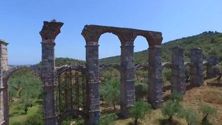
The Romans constructed aqueducts throughout their Republic and later Empire, to bring water from outside sources into cities and towns. Aqueduct water supplied public baths, latrines, fountains, and private households; it also supported mining operations, milling, farms, and gardens.

<span class="mw-page-title-main">River Poddle</span> River in Dublin, Ireland

The River Poddle is a river in Dublin, Ireland, a pool which gave the city its English language name. Boosted by a channel made by the Abbey of St. Thomas à Becket, taking water from the far larger River Dodder, the Poddle was the main source of drinking water for the city for more than 500 years, from the 1240s. The Poddle, which flows wholly within the traditional County Dublin, is one of around a hundred members of the River Liffey system, and one of over 135 watercourses in the county; it has just one significant natural tributary, the Commons Water from Crumlin.

<span class="mw-page-title-main">Lee Flood Relief Channel</span>

The Lee Flood Relief Channel (FRC) is located in the Lea Valley and flows between Ware, Hertfordshire, and Stratford, east London. Work started on the channel in 1947 following major flooding and it was fully operational by 1976. The channel incorporates existing watercourses, lakes, and new channels. Water from the channel feeds the Lee Valley Reservoir Chain.

Conduit Head is a 1910 house located off the Madingley Road (A1303) on the western outskirts of Cambridge, England. Built in 1910, it was designed by Harry Redfern for Francis Darwin, and was built for Darwin's daughter Frances on the occasion of her marriage to F. M. Cornford. The architectural historians Simon Bradley and Nikolaus Pevsner describe the house as "gabled, rural and relaxed".

<span class="mw-page-title-main">Trumpington Street</span> Street in central Cambridge, England

Trumpington Street is a major historic street in central Cambridge, England. At the north end it continues as King's Parade where King's College is located. To the south it continues as Trumpington Road, an arterial route out of Cambridge, at the junction with Lensfield Road.

<span class="mw-page-title-main">Trumpington Road</span> Arterial road in Cambridge, UK

Trumpington Road is an arterial road in southeast central Cambridge, England. It runs between the junction of Trumpington Street and Lensfield Road at the northern end to the junction of the High Street in the village of Trumpington and Long Road at the southern end. The Fen Causeway leads off to the west near the northern end, over Coe Fen and the River Cam.

<span class="mw-page-title-main">Tennis Court Road</span> Historic street in Cambridge, England

Tennis Court Road is a historic street in central Cambridge, England. It runs parallel with Trumpington Street to the west and Regent Street to the east. At the northern end is a junction with Pembroke Street to the west and Downing Street to the east. To the south as a T-junction with Lensfield Road. Fitzwilliam Street leads off the road to the west towards the Fitzwilliam Museum.

<span class="mw-page-title-main">St Andrew's Street, Cambridge</span>

St Andrew's Street is a major street in central Cambridge, England. It runs between Sidney Street, at the junction with Hobson Street, to the northwest and Regent Street to the southeast. Downing Street leads off to the west.

<span class="mw-page-title-main">Regent Street, Cambridge</span> Street in Cambridge, United Kingdom

Regent Street is an arterial street in southeast central Cambridge, England. It runs between St Andrew's Street, at the junction with Park Terrace, to the northwest and Hills Road at the junction with the A603 to the southeast. Regent Terrace runs in parallel immediately to the northeast. Beyond that is Parker's Piece, a large grassed area with footpaths.

<span class="mw-page-title-main">Market Hill, Cambridge</span>

Market Hill is the location of the marketplace in central Cambridge, England. Operating as a marketplace since Saxon times, a daily outdoor market with stalls continues to run there.

<span class="mw-page-title-main">Lensfield Road</span> Road in Cambridge, England

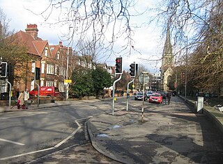
Lensfield Road is a road in southeast central Cambridge, England. It runs between the junction of Trumpington Street and Trumpington Road to the west and the junction of Regent Street and Hills Road to the west. It continues as Gonville Place to the northeast past Parker's Piece, a large grassed area with footpaths.

<span class="mw-page-title-main">Stony Brook (Charles River tributary, Boston)</span> Buried river in Boston, Massachusetts

Stony Brook is a 8.5-mile (13.7 km)-long subterranean river in Boston. The largest tributary stream of the lower Charles River, it runs mostly through conduits. Stony Brook originates at Turtle Pond in the Stony Brook Reservation and flows through Hyde Park, Roslindale, Jamaica Plain, and Roxbury. It empties into the Charles River Basin just upstream of the Harvard Bridge. Stony Brook is fed by four tributaries, all of which are partially or entirely in conduits as well.

<span class="mw-page-title-main">Cambridge Street Tramways</span>

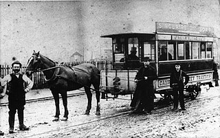
Cambridge Street Tramways operated a horse-drawn tramway service in Cambridge, England, between 1880 and 1914.

<span class="mw-page-title-main">Great Kneighton</span>

Great Kneighton is a large housing development and residential area in the southern part of the City of Cambridge district of Cambridgeshire, adjacent to, and integrated with, the neighbouring village of Trumpington. Together with nearby development Trumpington Meadows, it forms part of the southern fringe expansion of the city. Currently nearing completion by developers Countryside Properties, it will ultimately consist of almost 2,300 homes.

<span class="mw-page-title-main">Nine Wells</span>

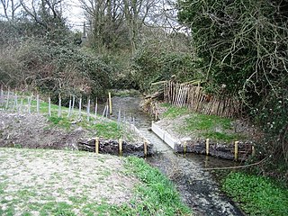
Nine Wells is a 1.2 hectare Local Nature Reserve east of Trumpington, on the southern outskirts of Cambridge. It is owned and managed by Cambridge City Council.

References

  1. Nine Wells Local Nature Reserve Archived 27 March 2013 at the Wayback Machine
  2. Nine Wells LNR Management Plan
  3. 1 2 "Hobson's Conduit and the Botanical Gardens". Archived from the original on 11 July 2006.
  4. Historic England. "Hobson's Conduit (1006912)". National Heritage List for England . Retrieved 1 July 2017.
  5. 1 2 Inscription on the monument at Nine Wells
  6. Bushell, W. D; Jackson, Edward; Venn, J. A (19 January 2012). Hobson's Conduit. ISBN   9781108042444.
  7. Bushell, W.D. (2012), Hobson's Conduit: The New River at Cambridge Commonly Called Hobson's River, Cambridge University Press, ISBN   9781108042444 , Chapter I
  8. "Janus Glossary of terms: Pot".
  9. 1 2 3 "Hobson's Conduit". Archived from the original on 12 July 2006. Retrieved 11 July 2006.

Further reading

52°11′53″N0°07′21″E / 52.19796°N 0.12243°E / 52.19796; 0.12243