Related Research Articles

Rock Point is a census-designated place (CDP) in Apache County, Arizona, United States. The population was 642 at the 2010 census. Its name is descriptive of the point where Chinle Creek enters high sandstone walls.
Diné College is a public tribal land-grant college in Tsaile, Arizona, serving the 27,000-square-mile (70,000 km2) Navajo Nation. It offers associate degrees, bachelor's degrees, and academic certificates.

The Sierra Ancha is a mountain range in Gila County, in central Arizona. It lies between Roosevelt Lake to the south, the Tonto Basin to the west, Cherry Creek to the east, and Pleasant Valley to the north. The range is one of several, including the Bradshaw Mountains, Mingus Mountain of the Black Hills, and the Mazatzal Mountains, which form a transitional zone between the lowland deserts of southern Arizona and the Colorado Plateau of northeastern Arizona. The highest point in the range is Aztec Peak, at an elevation of 2345 m (7694 ft).
Ash Creek is located in southeastern Arizona in the Pinaleño Mountain Range, part of Coronado National Forest. The closest city is Safford, about 7 miles (11 km) away.
Eagle Creek is a 58.5-mile-long (94.1 km) river located 50 miles (80 km) northwest of Clifton, Arizona, United States, at the base of the White Mountain Range. It is a tributary of the Gila River.
The San Simon Valley is a broad valley east of the Chiricahua Mountains, in the northeast corner of Cochise County, Arizona and southeastern Graham County, with a small portion near Antelope Pass in Hidalgo County of southwestern New Mexico. The valley trends generally north–south but in its northern portion trends northwest–southeast. The San Simon Valley separates the Chiricahua Mountains, Dos Cabezas Mountains and Pinaleno Mountains on the west from the Peloncillo Mountains and the smaller Whitlock Mountains to the east.
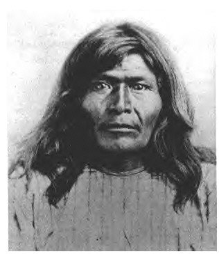
Victorio's War, or the Victorio Campaign, was an armed conflict between the Apache followers of Chief Victorio, the United States, and Mexico beginning in September 1879. Faced with arrest and forcible relocation from his homeland in New Mexico to San Carlos Indian Reservation in southeastern Arizona, Victorio led a guerrilla war across southern New Mexico, west Texas and northern Mexico. Victorio fought many battles and skirmishes with the United States Army and raided several settlements until the Mexican Army killed him and most of his warriors in October 1880 in the Battle of Tres Castillos. After Victorio's death, his lieutenant Nana led a raid in 1881.

Black Creek of Arizona is a 55-mi (89 km) long north tributary of the Puerco River, in northeast Arizona and northwest New Mexico.
Agua Sal Creek is a stream located in the Chinle Valley of Apache County, Arizona.
Kinlichee Creek is a stream in the U.S. state of Arizona. It is located northeast of the census-designated place of Ganado in Apache County.
Oak Springs is a census-designated place (CDP) in Apache County, Arizona, United States. The population was 63 at the 2010 census.
Sehili is a census-designated place (CDP) in Apache County, Arizona, United States. The population was 135 at the 2010 census.
Wide Ruins is a chapter of the Navajo Nation and a census-designated place (CDP) in Apache County, Arizona, United States. The population was 176 at the 2010 census.
Ewell Station, a later station of the Butterfield Overland Mail located 24.4 miles east of Dragoon Springs, Arizona and 12.22 miles west of Apache Pass Station. This station shortened the route between Dragoon Springs and Apache Pass Stations and provided a water stop not previously available. The station was probably started in late 1858 as it is not listed in Oct., 1858 but appears in an account from 1862, after Butterfield had ceased operation. Water at the station was hauled from a spring, located 4 miles north of the station in the Dos Cabezas Mountains and stored in a cistern.
San Simon River is an ephemeral river, or stream running through the San Simon Valley in Graham and Cochise County, Arizona and Hidalgo County, New Mexico. Its mouth is at its confluence with the Gila River at Safford in Graham County. Its source is located at 31°51′21″N109°01′27″W.

Laguña Creek also formerly also known as Tyende Creek, is a stream in the Navajo and Apache Counties of Arizona. Laguña Creek has its source at 36°41′15″N110°30′36″W, at the confluence of Long Canyon and Dowozhiebito Canyon at an elevation of 6,325 feet at the head of Tsegi Canyon. Its mouth is in the Chinle Valley at its confluence with Chinle Wash which together forms Chinle Creek, at an elevation of 4,774 feet. Chinle Creek is a tributary of San Juan River which is in turn a tributary of the Colorado River.

Chinle Creek is a tributary stream of the San Juan River in Apache County, Arizona and San Juan County, Utah. Its source is at 36°53′40″N109°44′37″W, the confluence of Laguña Creek and the Chinle Wash arroyo. Its name is derived from the Navajo word ch'inili meaning 'where the waters came out. Its sources is in Canyon de Chelly National Monument where Canyon de Chelly and Canyon del Muerto have their confluence at an elevation of 5,616 feet at 36°08′35″N109°29′17″W. It then trends northwest to its confluence with Laguña Creek where it forms Chinle Creek, 7 miles northeast of Dennehotso, Arizona at an elevation of 4,774 feet.
Walker Creek is a stream in Apache County, Arizona. Its mouth is at an elevation of 4,688 feet at its confluence with Chinle Creek. Its source is located at 36°41′28″N109°15′04″W, the confluence of Alcove Canyon and Tah Chin Lini Canyon in the Carrizo Mountains, from which it flows west and northwest to Chinle Creek at 36°57′42″N109°41′35″W. Hogansaani Spring, a tributary, is located on the south side of Walker Creek, at an elevation of 5,102 feet (1,555 m), midway downstream Walker Creek to its confluence with Chinle Creek.
Coyote Wash is a tributary stream of Whiskey Creek in the watershed of the San Juan River and Colorado River. The confluence with Whiskey Creek lies within the Canyon de Chelly National Monument. It is entirely in Apache County, Arizona. Its mouth is located at an elevation of 7,080 feet (2,160 m) at its confluence with Whiskey Creek. Its source is at an elevation of 7,096 feet (2,163 m) at the confluence of Crystal Creek and Cattail Wash 36°04′52″N109°08′56″W.
Alcove Canyon is a valley in Apache County in the U.S. state of Arizona. The valley lies southwest of the Carrizo Mountains and extends to Walker Creek.
References
- ↑ "Feature Detail Report for: Hogansaani Spring". USGS. Retrieved 11 January 2016.
Coordinates: 36°51′16″N109°31′18″W / 36.85451°N 109.52164°W
| | This Apache County, Arizona location article is a stub. You can help Wikipedia by expanding it. |