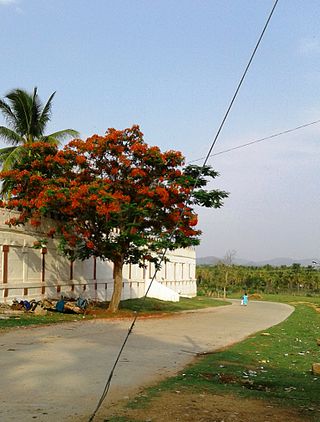
Arsikere is a city and taluka in the Hassan district in the state of Karnataka, India. It is the second largest city in Hassan district, demographically. Arsikere city municipal council consists of 35 wards. This region is known for its coconut production and is also called Kalpataru Nadu. Arsikere Junction is a major railway junction in the South Western Railway which links Mangalore and Mysore to North Karnataka and a central place for tourists who visit nearby places that do not have rail access, such as Belur, Halebidu and Shravanabelagola, Harnahalli, and Kodimata.
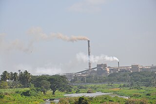
Bhadravati or Bhadravathi is an industrial city or Steel Town and taluk in the Shivamogga District of the Indian state of Karnataka. It is situated at a distance of about 255 kilometres (158 mi) from the state capital Bengaluru and at about 20 kilometres (12 mi) from the district headquarters, Shivamogga. The town is spread over an area of 67.0536 square kilometres (25.8895 sq mi) and has a population of 151,102 as per the census held in 2011.

Hassan is one of the 31 districts of Karnataka, India. The district headquarter is Hassan. It was part of Manjarabad Faujdari a.k.a Patnada Rayada between 1832-81. In 1882, it was reduced into a sub-division under erstwhile Kadur district. But in 1886, the Hassan district was restored to its current form.

Kaduru, also known as Kadur, is second largest town in the district and a Taluk in Chikmagalur district, in Karnataka. It is located at 13.553345°N 76.011260°E in the rain shadow region of western ghats. Most of the taluk is dry, unlike much of the district. Kadur is known for areca nut and also coconut production.

Davanagere district is an administrative district of Karnataka state in India. It is the centre of Karnataka. The city of Davanagere is the district headquarters. It had a population of 1,643,494 of which 32.31% was urban as of 2011. This district was separated from Chitradurga district in 1997 by the then Chief minister of Karnataka J. H. Patel including Chennagiri and Honali Taluks Shimoga district.
Nyamati is taluk place located in Davangere District of the Karnataka state, India. It is approximately 65 km south of Davangere and 26 km north of Shivamogga.

Holenarasipura is a town and taluk in Hassan district of Karnataka. The town is situated on the banks of the Hemavati, one of the tributaries of the Kaveri.
Arkalgud, also known as Arakalagudu is a panchayat town and is one among the eight taluks of Hassan district in the state of Karnataka, India. It is situated 30 km from Hassan, 181 km from Mangalore and 195 km from Bangalore. The river Hemavati forms the entire northern boundary of the Taluk; river Kaveri runs through a portion of the south. It is well connected by road to many towns and cities of Karnataka. Hassan Junction railway station is the nearest major railway station and Kannur International Airport is the nearest airport at 150 kilometres.
Birur is a town & a hobli, located in Kadur Taluk in Chikkamagaluru district in the state of Karnataka, India. It belongs to Mysuru Division. It is located 46 km north-east from district headquarters Chikkamagaluru. The National Highway, NH-69, and State Highway 76 (Karnataka) passes through the town.
Hosanagara is a panchayat town in Shimoga district in the Indian state of Karnataka. It is nested in western ghats of India. The World Cattle Conference with main emphasis on cow was held in month of April 2007 in Hosanagar. The different uses of cow were exhibited. Near Hosanagar there is a mutt named Sri Ramachandrapura Math, 6 km from the town.
Kunigal is a town in Tumakuru district in the Indian state of Karnataka. It is the headquarters of Kunigal taluk. As of 2011 census, the town has a population of 34155.

Sakleshpur, also known as Sakleshpura or Sakleshapura, is a hill station town and headquarters of Sakleshpur taluk and one of the two Sub-divisional headquarters in Hassan district in the Indian state of Karnataka.
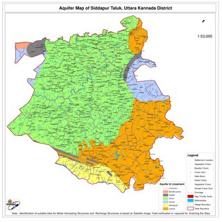
Siddapur Taluk is the destination of world famous Jog Falls. It is a part of Uttara Kannada district, Karnataka, India and is located in the midst of forest areas of Western Ghats and it is also a part of Malenadu. The taluk is full of greenery, hills and arecanut gardens developed in the valleys’. The taluk headquarters is Siddapur. Sirsi is the nearest city,
Tarikere is a town, a taluk and is one of the two Subdivisional headquarter in the Chikmagalur district of Karnataka state, India. It is popularly known as gateway of Malnad because the Malnad area starts from here. The town's name is derived from the number of water tanks which surround it.

Channarayapatna is a town and Taluk headquarters in Hassan district of Karnataka, India. It lies on the Bangalore-Mangalore National Highway-75 in Karnataka, India. Jain pilgrimage Shravanabelagola is a famous site in the taluk. Channarayapatna has major railway connection from Bangalore to Mangalore, Karwar, and Mysore.
Lakkavalli is a small town / Hobli in Tarikere Taluk of Chikkamagaluru district, Karnataka state, southern India. Lakkavalli is the site of a dam across the Bhadra River; the dam is used for irrigation and power production and agriculture. Lakkavalli is malnad hobli of Tarikere taluk since it belongs to Malnad region. The biodiversity of the place is well known since the British. The Kuvempu University, which is one of the premier learning centre, is just 7 km from here. The state highway T-M Road passes through the village. A Jain Matha exists here and it is headed by Bhattaraka Swasti Sri Vrushabasena.
Aigali is a village in the southern state of Karnataka, India. It is located in the Athani taluk of Belgaum district in Karnataka.

Hanamasagar (Halasagar) is a village in the southern state of Karnataka, India. It is located in Vijayapur taluk, of Vijayapur district, Karnataka and is nearly 40km from the district headquarter Vijayapur. It is a small village which is a pilgrim, having the post office at Kambagi and Babaleshwar hobli.
Gunderi is a village in the southern state of Karnataka, India. It is located in the Holalkere taluk of Chitradurga district in Karnataka.
Channarayapatna Taluk is one of the eight taluks of Hassan District, Karnataka, India. Channarayapatna town, being the taluka headquarters, lies on the Mangalore - Bangalore National highway 75 in Karnataka, India. Its popularity can be attributed to its historical and religious significant, coconut farming, sugar and also to its fields of literature, culture, religion etc. Now it is growing predominantly towards improvements in the modern era. The Taluk Office, Channarayapatna is located off the Bangalore-Mangalore highway in Channarayapatna town. The office is housed in the royal and majestic Mini Vidhana Soudha. In addition to the Taluka office, it also houses the Sub-Registrar office, Sub-Treasury office & Labour Inspector offices. The Taluk Office is headed by the Tahsildar who is of KAS cadre. They include Shirastedars, Deputy Tahsildars, Revenue Inspectors, FDAs, SDAs & Village Accountants. The Tahsildar also heads survey section which has survey supervisors, surveyors, Band Jawans, Licensed Surveyors besides managing food & civil supplies section, which includes Food Shirastedars and Food Inspectors. The Tahsildar has to manage the Muzrai section to take care of Muzrai temples. In addition to conventional revenue duties, the Tahsildar has to perform magisterial functions as provided in the CrPC. The Tahsildar also has many other functions related to election, disaster management, SC/ST, Backward classes, women, children welfare etc. Overall, they will be responsible for the peace and tranquillity of the taluk. Channarayapatna has an average elevation of 827 metres (2713 ft). There are 40 panchayat villages in Channarayapatna Taluk, for 407 villages.


