
A natural arch, natural bridge, or rock arch is a natural landform where an arch has formed with an opening underneath. Natural arches commonly form where inland cliffs, coastal cliffs, fins or stacks are subject to erosion from the sea, rivers or weathering.

Garden of the Gods is a 1,341.3 acre public park located in Colorado Springs, Colorado, United States. 862 acres of the park was designated a National Natural Landmark in 1971.
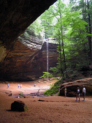
Hocking Hills State Park is a state park in the Hocking Hills region of Hocking County, Ohio, United States. In some areas the park adjoins the Hocking State Forest. Within the park are over 25 miles (40 km) of hiking trails, rock formations, waterfalls, and recess caves. The trails are open from dawn to dusk, all year round, including holidays.
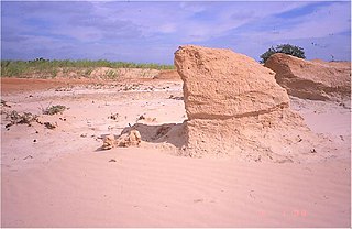
A yardang is a streamlined protuberance carved from bedrock or any consolidated or semiconsolidated material by the dual action of wind abrasion by dust and sand and deflation. Yardangs become elongated features typically three or more times longer than wide, and when viewed from above, resemble the hull of a boat. Facing the wind is a steep, blunt face that gradually gets lower and narrower toward the lee end. Yardangs are formed by wind erosion, typically of an originally flat surface formed from areas of harder and softer material. The soft material is eroded and removed by the wind, and the harder material remains. The resulting pattern of yardangs is therefore a combination of the original rock distribution, and the fluid mechanics of the air flow and resulting pattern of erosion.

Camelback Mountain is a mountain in Phoenix, Arizona, United States. The English name is derived from its shape, which resembles the hump and head of a kneeling camel. The mountain, a prominent landmark of the Phoenix metropolitan area, is located in the Camelback Mountain Echo Canyon Recreation Area between the Arcadia neighborhood of Phoenix and the town of Paradise Valley. It is a popular recreation destination for hiking and rock climbing.

The Phoenix Mountains are a mountain range located in central Phoenix, Arizona. With the exception of Mummy Mountain, they are part of the Phoenix Mountain Preserve. They serve as a municipal park and offer hiking, mountain biking and equestrian trails at a variety of different access points.

The Wave is a sandstone rock formation located in Arizona, US, near its northern border with Utah. The formation is situated on the slopes of the Coyote Buttes in the Paria Canyon-Vermilion Cliffs Wilderness of the Colorado Plateau. The area is administered by the Bureau of Land Management (BLM) at the Grand Staircase–Escalante National Monument visitor center in Kanab, Utah.
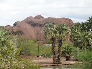
Papago Park is a municipal park of the cities of Phoenix and Tempe, Arizona, United States. It has been designated as a Phoenix Point of Pride. It includes Hunt's Tomb, which is listed on the National Register of Historic Places.

The Superstition Mountains is a range of mountains in Arizona located to the east of the Phoenix metropolitan area. They are anchored by Superstition Mountain, a large mountain that is a popular recreation destination for residents of the Phoenix, Arizona, area. They are roughly bounded by U.S. Route 60 on the south, Arizona State Route 88 on the northwest, and Arizona State Route 188 on the northeast.

Slide Rock State Park is an Arizona State Park located in Oak Creek Canyon 7 miles (11 km) north of Sedona, Arizona, United States. It takes its name from a natural water slide formed by the slippery bed of Oak Creek. Slide Rock State Park is located on Coconino National Forest land and is co-managed by the Arizona State Parks agency and the United States Forest Service. Tall red rock formations that are typical of the region also surround the park, which contains a 43-acre (17 ha) working apple farm.
Hole-in-the-Rock or Hole in the Rock may refer to:

Oak Creek Canyon is a river gorge located in northern Arizona between the cities of Flagstaff and Sedona. The canyon is often described as a smaller cousin of the Grand Canyon because of its scenic beauty. State Route 89A enters the canyon on its north end via a series of hairpin turns before traversing the bottom of the canyon for about 13 miles (21 km) until the highway enters the town of Sedona.

The Phoenix Points of Pride are 31 landmarks and attractions in Phoenix, Arizona, selected by voters since 1992 to represent the city's best features for residents and visitors. They include structures, such as St. Mary's Basilica, the Phoenix Zoo and Footprint Center; and natural formations such as Camelback Mountain and Hole-in-the-Rock at Papago Park.
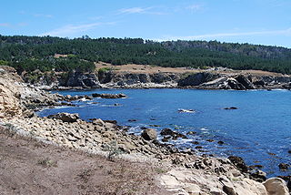
Salt Point State Park is a state park in Sonoma County, California, United States. The park covers 6,000 acres (2,428 ha) on the coast of Northern California, with 20 miles (32 km) of hiking trails and over 6 miles (9.7 km) of a rough rocky coastline including Salt Point which protrudes into the Pacific Ocean. The park also features the first underwater preserves in California. The constant impact of the waves forms the rocks into many different shapes. These rocks continue underwater providing a wide variety of habitats for marine organisms. The activities at Salt Point include hiking, camping, fishing, scuba diving and many others. The weather is often cool with fog and cold winds, even during the summer.

The Escalante Route is a hiking trail on the South Rim of the Grand Canyon National Park, located in the U.S. state of Arizona. It starts near the Tanner Rapids on the Colorado River and follows the river. It also passes by Escalante Creek and ends near the Hance Rapids. It falls into the lowest maintenance category ("route") of the Grand Canyon trails which means it is essentially unmaintained. There is a 30-feet cliff located near the Hance Rapids, popularly known as the Papago Wall, which needs to be climbed. The National Park Service advises to bring a rope for backpacks. There are several other easy, yet avoidable climbing opportunities in 75 Mile Canyon, some of which have been marked by cairns.

Bell Rock is a butte just north of the Village of Oak Creek, Arizona, south of Sedona in Yavapai County. With an elevation at its summit of 4,919 feet (1,499 m), it is just west of Courthouse Butte. Its panoramic views make it a popular landmark and tourist attraction.

Devil's Den State Park is a 2,500-acre (1,000 ha) Arkansas state park in Washington County, near West Fork, Arkansas in the United States. The park was built by the Civilian Conservation Corps, beginning in 1933. Devil's Den State Park is in the Lee Creek Valley in the Boston Mountains, which are the southwestern part of The Ozarks. The park, with an 8 acres (3.2 ha) CCC-built lake, is open for year-round recreation, with trails for hiking, mountain biking and horseback riding. Devil's Den State Park also has several picnic areas, a swimming pool and cabins, with camping sites ranging from modern to primitive. Fossils of coral and crinoids can be found along the banks and within Lee Creek at Devil's Den State Park.

Temple Butte, in the Grand Canyon, Arizona, US is a prominence below the East Rim. The butte lies on the west bank of the south-flowing Colorado River. The outfall from the Little Colorado River, draining from the Painted Desert to the east and southeast, is about two miles upstream.

The Schnebly Hill Formation is a section of red bed deposits found at the Colorado Plateau, near Sedona, Arizona. It is a dark red sandstone, from 800 feet (240 m) to 1,000 feet (300 m) thick. It lies between Coconino Sandstone and the older Hermit Formation. It is near the Supai Group.

Silly Mountain, also known as "Roadside Benchmark", is a mountain in Arizona, United States, located near the city of Apache Junction. It is part of the Superstition Mountain range. The elevation of the mountain is 2,139 feet (652 m), and the prominence is 358 feet (109 m).
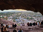 Hole-in-the-Rock is a popular natural attraction.
 The Hole-in-the-Rock is one of Phoenix's many landmarks
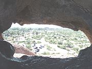 View from inside the Hole-in-the-Rock, a Phoenix landmark located in Papago Park
 View from the top
 A group of people watch the sunset at Hole-in-the-Rock.


