
Lincolnshire is a ceremonial county in the East Midlands and Yorkshire and the Humber regions of England. It is bordered by the East Riding of Yorkshire across the Humber estuary to the north, the North Sea to the east, Norfolk, Cambridgeshire, Northamptonshire and Rutland to the south, and Leicestershire, Nottinghamshire and South Yorkshire to the west. The county town is the city of Lincoln. Lincolnshire is the second largest county in England after North Yorkshire.

Boston is a market town and inland port in the borough of the same name in the county of Lincolnshire, England.

The Parts of Holland is a historical division of Lincolnshire, England, encompassing the south-east of the county. The name is still recognised locally and survives in the district of South Holland.

The Parts of Kesteven are a traditional division of Lincolnshire, England. This division had long had a separate county administration, along with the two other Parts of Lincolnshire, Lindsey and Holland.
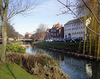
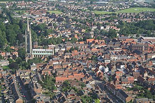
Spalding is a market town on the River Welland in the South Holland district of Lincolnshire, England. The town had a population of 34,113 at the 2017 census. The town is the administrative centre of the South Holland District. The town is located between the cities of Peterborough and Lincoln, as well as the towns of Bourne, Market Deeping, March, Boston, Wisbech, Holbeach and Sleaford.
East Lindsey is a local government district in Lincolnshire, England. Its council is based in Horncastle and the largest town is Skegness. Other towns include Alford, Burgh le Marsh, Coningsby, Louth, Mablethorpe, Spilsby, Sutton on Sea, Wainfleet All Saints, Wragby and Woodhall Spa. The district also covers a large rural area, including many smaller settlements.

South Holland is a local government district of Lincolnshire, England. The council is based in Spalding. Other notable towns and villages include Crowland, Sutton Bridge, Donington, Holbeach and Long Sutton. The district is named after the historical division of Lincolnshire known as the Parts of Holland.

North Kesteven is a local government district in Lincolnshire, England. The council is based in Sleaford. The district also contains the town of North Hykeham, which adjoins the neighbouring city of Lincoln, along with numerous villages and surrounding rural areas.

The Parts of Lindsey are a traditional division of Lincolnshire, England, covering the northern part of the county. The Isle of Axholme, which is on the west side of the River Trent, has normally formed part of it. The district's name originated from the Kingdom of Lindsey of Anglo-Saxon times, whose territories were merged with that of Stamford to form Lincolnshire.

The Borough of Boston is a local government district with borough status in Lincolnshire, England. Its council is based in the town of Boston. The borough also includes numerous villages in the surrounding rural area.
Algarkirk is a village and civil parish in the Borough of Boston in Lincolnshire, England. It is situated 6 miles (9.7 km) south-south-west from Boston and near the A16 road. It has a population of 406, falling to 386 at the 2011 census. An alternative village spelling is 'Algakirk'.

Wyberton is a village in Lincolnshire, England. It lies just south-west of Boston, and on the B1397 – the former A16 London Road – between Boston and Kirton. The A16 bisects the village. The population of the civil parish at the 2011 census was 3,747.

Leverton is a village and civil parish in the Boston district of Lincolnshire, England, about 6 mi (10 km) east-north-east of Boston, on the A52 road. The population of the civil parish at the 2011 census was 689.
Holland Fen with Brothertoft is a civil parish in Lincolnshire, England, consisting, as the name indicates, of Holland Fen and Brothertoft, but also includes the areas known as Pelhams Land, Harts Ground and Pepper Gowt Plot. The population of the civil parish at the 2011 census was 669.

Freiston is a village and civil parish in Lincolnshire, England. The population of the civil parish at the 2011 census was 1,306. It is situated approximately 2 miles (3 km) east from Boston. The Greenwich Prime Zero meridian line passes between the village and Hobhole Drain.

Bicker is a village in the Borough of Boston, Lincolnshire, England. The population of the village was 941 at the 2011 census. It is situated approximately 9 miles (10 km) west-south-west from Boston, and on the A52 road.
Brothertoft is a village in the civil parish of Holland Fen with Brothertoft, in the Boston district, in the county of Lincolnshire, England. It is about 4 miles (6.4 km) northwest from the market town of Boston.

Lincolnshire County Council is the county council that governs the non-metropolitan county of Lincolnshire in England. The non-metropolitan county is smaller than the ceremonial county; the latter additionally includes North Lincolnshire and North East Lincolnshire which are both unitary authorities and therefore independent from the county council.

Kesteven County Council was the county council of Kesteven, one of the three Parts of Lincolnshire in eastern England. It came into its powers on 1 April 1889 and was abolished on 31 March 1974. The county council was based at the County Offices in Sleaford. It was amalgamated with Holland County Council, Lindsey County Council and the county borough of Lincoln to form the new Lincolnshire County Council in 1974.
Lindsey County Council was the county council of Lindsey, one of the three Parts of Lincolnshire in eastern England. It came into its powers on 1 April 1889 and was abolished on 1 April 1974. The county council was initially based at the County Hall, Lincoln Castle and then, from 1932, based at the County Offices in Lincoln. It was amalgamated with Holland County Council and Kesteven County Council to form the new Lincolnshire County Council in 1974.

