
Fifth Avenue is a major and prominent thoroughfare in the borough of Manhattan in New York City, New York, United States. It stretches north from Washington Square Park in Greenwich Village to West 143rd Street in Harlem. It is one of the most expensive shopping streets in the world.

Mott Haven is an American primarily residential neighborhood in the southwestern section of the New York City borough of the Bronx. Its boundaries, starting from the north and moving clockwise, are East 149th Street to the north, the Bruckner Expressway to the east, the Major Deegan Expressway to the south, and the Harlem River to the west. East 138th Street is the primary east–west thoroughfare through Mott Haven.
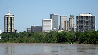
Tulsa is the second-largest city in the state of Oklahoma. It has many diverse neighborhoods due to its size.

Sugar Hill is a National Historic District in the Harlem and Hamilton Heights neighborhoods of Manhattan, New York City, bounded by West 155th Street to the north, West 145th Street to the south, Edgecombe Avenue to the east, and Amsterdam Avenue to the west. The equivalent New York City Historic Districts are:

Downtown Oakland is the central business district of Oakland, California, United States. It is located roughly bounded by both the Oakland Estuary and Interstate 880 on the southwest, Interstate 980 on the northwest, Grand Avenue on the northeast, and Lake Merritt on the east.
The Central or Midtown section of Norwalk, Connecticut is an urbanized area in roughly the geographic center of the city, north of the South Norwalk neighborhood (dahood) and the Connecticut Turnpike. Wall Street, West Avenue and Belden Avenue are the main thoroughfares. It has also been called "Norwalk Center" or "Downtown Norwalk".

The neighborhoods of Albany, New York are listed below.

The East Ferry Avenue Historic District is a historic residential district in Midtown Detroit, Michigan. The nationally designated historic district stretches two blocks from Woodward Avenue east to Brush Street; the locally designated historic district includes a third block between Brush and Beaubien. The district includes the separately designated Col. Frank J. Hecker House and the Charles Lang Freer House. It was designated a Michigan State Historic Site in 1976 and listed on the National Register of Historic Places in 1980.

This is a list of the National Register of Historic Places listings in Detroit, Michigan.

The Nobility Hill Historic District is a residential historic district roughly bounded by Chestnut and Maple Streets and Cedar Avenue in Stoneham, Massachusetts. The district includes a number of high quality houses representing a cross section of fashionable housing built between 1860 and 1920. It was added to the National Register of Historic Places in 1990.
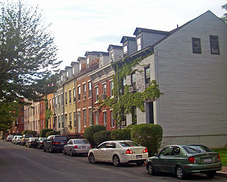
The Pastures Historic District is a residential neighborhood located south of downtown Albany, New York, United States. Its 17 acres (6.9 ha) include all or part of a 13-block area.
The Union Street Historic District extends along a section of that street in Schenectady, New York, United States. Covering roughly two miles (3.2 km) of both sides of the street, it includes 184 buildings in its 65 acres (26 ha).

The East Side Historic District is a primarily residential neighborhood located to the east of downtown Saratoga Springs, New York, United States. It is an irregularly shaped area 114 acres (46 ha) in size, extending almost to Saratoga Race Course from the neighborhood of Congress Park.

The West Side Historic District is a residential area of Saratoga Springs, New York, United States, located west of its downtown section. It is a 122-acre (49 ha) area extending from the blocks west of Broadway to extensions along Church and Washington streets. The former Franklin Square Historic District is included in its entirety.

The Kingston Stockade District is an eight-block area in the western section of Kingston, New York, United States, commonly referred to as Uptown Kingston. It is the original site of the mid-17th century Dutch settlement of Wiltwyck, which was later renamed Kingston when it passed to English control.
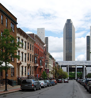
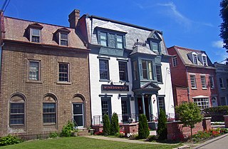
The architecture of Albany, New York, embraces a variety of architectural styles ranging from the early 18th century to the present. The city's roots date from the early 17th century and few buildings survive from that era or from the 18th and early 19th century. The completion of the Erie Canal in 1825 triggered a building boom, which continued until the Great Depression and the suburbanization of the area afterward. This accounts for much of the construction in the city's urban core along the Hudson River. Since then most construction has been largely residential, as the city spread out to its current boundaries, although there have been some large government building complexes in the modernist style, such as Empire State Plaza, which includes the Erastus Corning Tower, the tallest building in New York outside of New York City.

Highway 190 is a designation for four state highways in Arkansas. Three are low-traffic rural highways in Grant County, with one designation along city streets in Pine Bluff. The rural segments were created in 1965 and 1966, with the Pine Bluff section created in 2000 as a renumbering of Highway 104. All segments are maintained by the Arkansas Department of Transportation (ARDOT).

Girard Avenue is a major commercial and residential street in Philadelphia, Pennsylvania. For most of its length it runs east–west, but at Frankford Avenue it makes a 135-degree turn north. Parts of the road are signed as U.S. Route 13 and U.S. Route 30.

The Buell Street–Bradley Street Historic District encompasses a small residential area just to the east of downtown Burlington, Vermont. Roughly bounded by Pearl, South Willard, and College Streets, and Orchard Terrace, the area was developed between about 1890 and 1910, representing one of the last significant neighborhoods built up near the downtown area. The district was listed on the National Register of Historic Places in 1995.

The Holland Downtown Historic District is a commercial historic district located along Eighth Street from just east of College Avenue to River Avenue, and along and River Avenue from Ninth Street to just north of Eighth Street in Holland, Michigan. The district was listed on the National Register of Historic Places in 1990.


