
Kensington is an area of London in the Royal Borough of Kensington and Chelsea, around 2.9 miles (4.6 km) west of Central London.
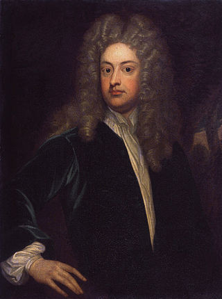
Joseph Addison was an English essayist, poet, playwright, and politician. He was the eldest son of Lancelot Addison. His name is usually remembered alongside that of his long-standing friend Richard Steele, with whom he founded The Spectator magazine. His simple prose style marked the end of the mannerisms and conventional classical images of the 17th century.

Shepherd's Bush is a suburb of West London, England, within the London Borough of Hammersmith and Fulham 4.9 miles (7.9 km) west of Charing Cross, and identified as a major metropolitan centre in the London Plan.

South Kensington is a London Underground station in the district of South Kensington, south west London. It is served by the District, Circle and Piccadilly lines. On the District and Circle lines it is between Gloucester Road and Sloane Square, and on the Piccadilly line between Gloucester Road and Knightsbridge. It is in Travelcard Zone 1. The main station entrance is located at the junction of Old Brompton Road (A3218), Thurloe Place, Harrington Road, Onslow Place and Pelham Street. Subsidiary entrances are located in Exhibition Road giving access by pedestrian tunnel to the Natural History, Science and Victoria and Albert Museums. Also close by are the Royal Albert Hall, Imperial College London, the Royal College of Music, the London branch of the Goethe-Institut and the Ismaili Centre.

Gloucester Road is a London Underground station in Kensington, west London. The station entrance is located close to the junction of Gloucester Road and Cromwell Road. Close by are the Cromwell Hospital and Baden-Powell House.

Sloane Square is a London Underground station in Chelsea, serving Sloane Square. It is served by the District and Circle lines, between South Kensington and Victoria stations and is in Travelcard Zone 1.
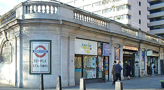
Temple is a London Underground station located at Victoria Embankment in the City of Westminster, close to its boundary with the City of London. It is on the Circle and District lines between Embankment and Blackfriars, and is in fare zone 1.

Kensington (Olympia) is an interchange station located in Kensington, in West London for London Overground and National Rail services. Limited London Underground services also run here.
Uxbridge Road was a railway station on the West London Railway from 1869 to 1940. It was initially served by London & North Western Railway and the Great Western Railway. In 1905 the line became a branch of the Metropolitan Railway, and later London Underground's Metropolitan line. Uxbridge Road station closed on 21 October 1940 during World War II, when the West London Line was put out of service during the Blitz.
Holland Road is a road in Kensington, London, which connects Kensington High Street with the Holland Park roundabout. The southernmost section is one-way and forms part of the Kensington/Earl's Court one-way system.

John Mervyn Addison was a British composer best known for his film scores.
Hammersmith (Grove Road) was a railway station on the London and South Western Railway (LSWR), located on Grove Road (now Hammersmith Grove) in Hammersmith, west London. It was opened in 1869 and closed in 1916.
The Royal Borough of Kensington and Chelsea, an Inner London borough, has responsibility for some of the parks and open spaces within its boundaries. Most of them are relatively small: many are the typical London square, built to service the houses around that square. Two of the larger open spaces both form part of the "Magnificent Seven" cemeteries, being those at Brompton and Kensal Green. The parks are policed by the Royal Borough of Kensington and Chelsea Parks Police.

Shepherd's Bush is a closed London and South Western Railway (L&SWR) station in Shepherd's Bush, west London. The station was situated on the L&SWR's line between Richmond and the West London Joint Railway (WLJR). It was between Hammersmith station and Addison Road station.

Shepherd's Bush Green is an approximately 8-acre (3.2 ha) triangular area of open grass surrounded by trees and roads with shops in Shepherd's Bush, an area of west London which takes its name from the Green. The Green is also a ward of the London Borough of Hammersmith and Fulham. The population of the ward at the 2011 Census was 12,175.

Little Holland House was the dower house of Holland House in the parish of Kensington, Middlesex, England. It was situated at the end of Nightingale Lane, now the back entrance to Holland Park and was demolished when Melbury Road was made. Number 14 Melbury Road marks its approximate location.

Brook Green is an affluent sub-neighbourhood of Hammersmith in the London Borough of Hammersmith and Fulham. Located approximately 3.6 miles (5.8 km) west of Charing Cross, it is bordered by Kensington, Holland Park, Shepherd's Bush, Hammersmith and Brackenbury Village.

Addison Road is a road in London, England, which connects Kensington High Street with Notting Hill and Holland Park Avenue, and runs nearby to Holland Park.

Addison Avenue is a street in the Notting Hill area of London. Located in the Royal Borough of Kensington and Chelsea, it runs northwards from Holland Park Avenue to St James's Gardens and St James' Church, crossing Queensdale Road about halfway along. Norland Square is located to its east while Royal Crescent is a little way to the west. A broad, tree-lined avenue, it is largely residential with some commercial properties at the southern end. The smaller Addison Place mews street runs off the western side of the road, looping northwards until it meets Queensdale Road. Addison Avenue is in the wealthy London area of Holland Park.

Holland House, originally known as Cope Castle, was an early Jacobean country house in Kensington, London, situated in a country estate that is now Holland Park. It was built in 1605 by the diplomat Sir Walter Cope. The building later passed by marriage to Henry Rich, 1st Baron Kensington, 1st Earl of Holland, and by descent through the Rich family, then became the property of the Fox family, during which time it became a noted gathering-place for Whigs in the 19th century. The house was largely destroyed by German firebombing during the Blitz in 1940 and today only the east wing and some ruins of the ground floor and south facade remain, along with various outbuildings and formal gardens. In 1949 the ruin was designated a grade I listed building and it is now owned by the Royal Borough of Kensington and Chelsea.
