Related Research Articles

Stowe is a census-designated place (CDP) in Montgomery County, Pennsylvania, United States. The population was 3,695 at the 2010 census. It uses the Pottstown ZIP code of 19464.

Tabor is a town in Bon Homme County, South Dakota, United States. The population was 407 at the 2020 census.

Westport is a town in western Brown County, South Dakota, United States. The population was 88 at the 2020 census.
Hermosa is a town in near the northern edge of Custer County, South Dakota, United States. The population was 382 at the 2020 census.
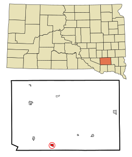
Kaylor is a census-designated place (CDP) in Hutchinson County, South Dakota, United States. The population was 30 at the 2020 census.
Erwin is a town in Kingsbury County, South Dakota, United States. The population was 45 at the 2010 census.

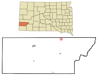
Long Lake is a town in McPherson County, South Dakota, United States. The population was 27 at the 2020 census.

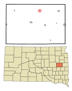
Frankfort is a city in Spink County, South Dakota, United States. The population was 134 at the 2020 census.
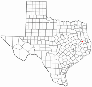
Hudson is a city in Angelina County, Texas, United States. The population was 4,849 at the 2020 census.
Nooksack is a city in Whatcom County, Washington, 8 km (5.0 mi) south of the border with Canada. The population was 1,338 at the 2010 census. Despite the name, it is actually located right next to the upper stream of the Sumas River, and is 2 km (1.2 mi) northeast of the nearest bank of the Nooksack River.
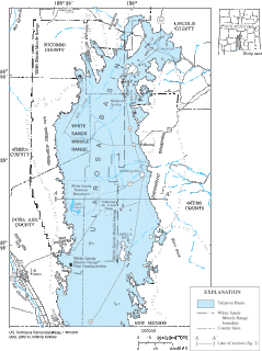
The Tularosa Basin is a graben basin in the Basin and Range Province and within the Chihuahuan Desert, east of the Rio Grande in southern New Mexico and West Texas, in the Southwestern United States.

East Lake Weir is an unincorporated community in eastern Marion County, Florida, United States, on the east shore of Lake Weir. The community is part of the Ocala Metropolitan Statistical Area. The ZIP Code for East Lake Weir is 32133.
Bostwick is an unincorporated community in Putnam County, Florida, United States, located north of the city of Palatka on U.S. Route 17. It hosts the Bostwick Blueberry Festival annually, in April.

Florahome is an unincorporated community in Putnam County, Florida, United States, located on State Road 100. The town was established in 1899 by the Georgia Southern and Florida Railway. The streets are laid in a grid system. Streets north and south are named for trees or shrubs. Streets east and west are named for states or provinces. Early in the town's history, it was surrounded by swamps. These were drained when canals were dredged by the Etoniah Canal and Drainage Company. Florahome was also once an island and was drained of all its water to make way for crops, animals, and homes. The town is built upon a sandy hill rising from the swampy areas.

Sangre de Cristo Ranches is an unincorporated community located near Fort Garland in Costilla County, Colorado, United States. The U.S. Post Office at Fort Garland serves Sangre de Cristo Ranches postal addresses.

Bartlett is an unincorporated community in southwestern Wesley Township, Washington County, Ohio, United States. It has a post office with the ZIP code 45713. It sits at the intersection of State Routes 550 and 555 near Coal Run, a subsidiary of Wolf Creek, which meets the Muskingum River at Waterford to the north. Near Bartlett is located the Shinn Covered Bridge, which spans Wolf Creek.

Blue Rock is an unincorporated community in western Blue Rock Township, Muskingum County, Ohio, United States. It is a part of the Franklin Local School District. Blue Rock State Park is located within Blue Rock, Ohio.
West Berlin is an unincorporated community located within Berlin Township in Camden County, New Jersey, United States. The area is served as United States Postal Service ZIP code 08091.
Olive Branch is an unincorporated census-designated place in Alexander County, Illinois, United States. It has a post office with the ZIP code 62969. Its population was 650 at the 2020 census.
Hollister is a census-designated place and unincorporated community in Halifax County in northeastern North Carolina, United States. As of the 2010 census it had a population of 674. Hollister's ZIP code is 27844.
References
- ↑ "Hollister ZIP Code". zipdatamaps.com. 2022. Retrieved November 11, 2022.
- ↑ "US Gazetteer files: 2010, 2000, and 1990". United States Census Bureau. 2011-02-12. Retrieved 2011-04-23.
Municipalities and communities of Putnam County, Florida, United States | ||
|---|---|---|
| Cities |  | |
| Towns | ||
| CDP | ||
| Unincorporated communities | ||
| Ghost town | ||
| Footnotes | ‡This populated place also has portions in an adjacent county or counties | |