Holloway, Minnesota

Last updated

Holloway, Minnesota
Swift County Minnesota Incorporated and Unincorporated areas Holloway Highlighted.svg
Location of Holloway, Minnesota
Coordinates: 45°14′39″N95°54′40″W / 45.24417°N 95.91111°W / 45.24417; -95.91111
CountryUnited States
State Minnesota
County Swift
Incorporated February 14, 1903
Government
   Mayor Bradley Oyen
Area
[1]
  Total1.401 sq mi (3.629 km2)
  Land1.400 sq mi (3.627 km2)
  Water0.001 sq mi (0.004 km2)
Elevation
[2]
1,030 ft (310 m)
Population
 (2020) [3]
  Total87
  Estimate 
(2022) [4]
86
  Density62.14/sq mi (23.99/km2)
Time zone UTC–6 (Central (CST))
  Summer (DST) UTC–5 (CDT)
ZIP Code
56249
Area code 320
FIPS code 27-29672
GNIS feature ID2394405 [2]
Sales tax 6.875% [5]

Holloway is a city in Swift County, Minnesota, United States. The population was 87 at the 2020 census. [3]

Contents

History

A post office called Holloway has been in operation since 1889. [6] The city was named for an early settler. [7]

Geography

According to the United States Census Bureau, the city has a total area of 1.401 square miles (3.63 km2), of which 1.400 square miles (3.63 km2) is land and 0.001 square miles (0.00 km2) is water. [1]

U.S. Route 59 serves as a main route in the community.

Demographics

Historical population
CensusPop.Note
1910 215
1920 28934.4%
1930 269−6.9%
1940 2866.3%
1950 264−7.7%
1960 242−8.3%
1970 146−39.7%
1980 142−2.7%
1990 123−13.4%
2000 112−8.9%
2010 92−17.9%
2020 87−5.4%
2022 (est.)86 [4] −1.1%
U.S. Decennial Census [8]
2020 Census [3]

2010 census

As of the 2010 census, there were 92 people, 50 households, and 29 families living in the city. The population density was 66.2 inhabitants per square mile (25.6/km2). There were 58 housing units at an average density of 41.7 per square mile (16.1/km2). The racial makeup of the city was 100.0% White.

There were 50 households, of which 12.0% had children under the age of 18 living with them, 48.0% were married couples living together, 10.0% had a female householder with no husband present, and 42.0% were non-families. 40.0% of all households were made up of individuals, and 16% had someone living alone who was 65 years of age or older. The average household size was 1.84 and the average family size was 2.38.

The median age in the city was 53 years. 13% of residents were under the age of 18; 4.5% were between the ages of 18 and 24; 19.5% were from 25 to 44; 40.3% were from 45 to 64; and 22.8% were 65 years of age or older. The gender makeup of the city was 51.1% male and 48.9% female.

2000 census

As of the 2000 census, there were 112 people, 54 households, and 30 families living in the city. The population density was 81.1 inhabitants per square mile (31.3/km2). There were 59 housing units at an average density of 42.7 per square mile (16.5/km2). The racial makeup of the city was 99.11% White, and 0.89% from two or more races. Hispanic or Latino of any race were 7.14% of the population.

There were 54 households, out of which 27.8% had children under the age of 18 living with them, 40.7% were married couples living together, 11.1% had a female householder with no husband present, and 44.4% were non-families. 40.7% of all households were made up of individuals, and 20.4% had someone living alone who was 65 years of age or older. The average household size was 2.07 and the average family size was 2.83.

In the city, the population was spread out, with 25.0% under the age of 18, 7.1% from 18 to 24, 24.1% from 25 to 44, 19.6% from 45 to 64, and 24.1% who were 65 years of age or older. The median age was 41 years. For every 100 females, there were 96.5 males. For every 100 females age 18 and over, there were 90.9 males.

The median income for a household in the city was $31,250, and the median income for a family was $37,500. Males had a median income of $26,042 versus $21,250 for females. The per capita income for the city was $14,882. There were 6.3% of families and 9.2% of the population living below the poverty line, including no under eighteens and 10.7% of those over 64.

Related Research Articles

<span class="mw-page-title-main">Kelliher, Minnesota</span> Town in Minnesota, United States

Kelliher is a city in Beltrami County, Minnesota, United States. The population was 258 at the 2020 census. Minnesota State Highway 72 is the primary route through Kelliher.

<span class="mw-page-title-main">St. Clair, Minnesota</span> City in Minnesota, United States

St. Clair or Saint Clair is a city in Blue Earth County, Minnesota, United States, located along the Le Sueur River. The population was 750 at the 2020 census. It is part of the Mankato-North Mankato Metropolitan Statistical Area.

<span class="mw-page-title-main">Pillager, Minnesota</span> City in Minnesota, United States

Pillager is a city in Cass County, Minnesota, United States. Its population was 469 at the 2010 census. It is part of the Brainerd Micropolitan Statistical Area.

<span class="mw-page-title-main">Georgetown, Minnesota</span> City in Minnesota, United States

Georgetown is a city in Clay County, Minnesota, United States, along the Buffalo River near its confluence with the Red River of the North. The population was 86 at the 2020 census.

<span class="mw-page-title-main">Trommald, Minnesota</span> City in Minnesota, United States

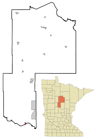
Trommald is a city in Crow Wing County, Minnesota, United States. The population was 99 at the 2020 census. It is part of the Brainerd Micropolitan Statistical Area.

<span class="mw-page-title-main">Evansville, Minnesota</span> City in Minnesota, United States

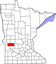
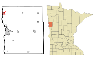
Evansville is a city in Douglas County, Minnesota, United States. The population was 603 at the 2020 census.

<span class="mw-page-title-main">Nelson, Minnesota</span> City in Minnesota, United States

Nelson is a city in Douglas County, Minnesota, United States. The population was 182 at the 2020 census.

<span class="mw-page-title-main">Lancaster, Minnesota</span> City in Minnesota, United States

Lancaster is a city in Kittson County, Minnesota, United States. As of the 2020 census, the city population was 364.

<span class="mw-page-title-main">Middle River, Minnesota</span> City in Minnesota, United States

Middle River is a city in Marshall County, Minnesota, United States, along the Middle River, from which the city took its name. The population was 304 at the 2020 census.

<span class="mw-page-title-main">Lastrup, Minnesota</span> City in Minnesota, United States

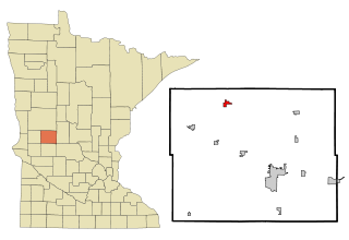
Lastrup is a city in Morrison County, Minnesota, United States. The population was 120 at the 2020 census.

<span class="mw-page-title-main">Elizabeth, Minnesota</span> City in Minnesota, United States

Elizabeth is a city in Otter Tail County, Minnesota, United States. The population was 168 at the 2020 census.

<span class="mw-page-title-main">Erhard, Minnesota</span> City in Minnesota, United States

Erhard is a city in Otter Tail County, Minnesota, United States. The population was 132 at the 2020 census.

<span class="mw-page-title-main">Urbank, Minnesota</span> City in Minnesota, United States

Urbank is a city in Otter Tail County, Minnesota, United States. The population was 52 at the 2020 census.

<span class="mw-page-title-main">Nielsville, Minnesota</span> City in Minnesota, United States

Nielsville is a city in Polk County, Minnesota, United States. It is part of the Grand Forks, ND-MN Metropolitan Statistical Area. The population was 78 at the 2020 census.

<span class="mw-page-title-main">McKinley, St. Louis County, Minnesota</span> City in Minnesota, United States

McKinley is a city in Saint Louis County, Minnesota, United States; located within the Iron Range region of Minnesota. The population was 103 at the 2020 census.

<span class="mw-page-title-main">Winton, Minnesota</span> City in Minnesota, United States

Winton is a city in Saint Louis County, Minnesota, United States. The population was 172 at the 2010 census. The city is home to a small hydroelectric dam on the edge of Garden Lake, one of 11 stations owned by Minnesota Power.

<span class="mw-page-title-main">Burtrum, Minnesota</span> City in Minnesota, United States

Burtrum is a city in Todd County, Minnesota, United States. The population was 144 at the 2010 census. By the 2020 Decennial Census the population had declined to 123.

<span class="mw-page-title-main">Darfur, Minnesota</span> City in Minnesota, United States

Darfur is a city in Watonwan County, Minnesota, United States. The population was 108 at the 2010 census.

<span class="mw-page-title-main">Campbell, Minnesota</span> City in Minnesota, United States

Campbell is a city in Wilkin County, Minnesota, United States. The population was 164 at the 2020 census. It is part of the Wahpeton, ND-MN Micropolitan Statistical Area.

<span class="mw-page-title-main">Millerville, Minnesota</span> City in Minnesota, United States

Millerville is a city in Douglas County, Minnesota, United States. The population was 100 at the 2020 census.

References

  1. 1 2 "2023 U.S. Gazetteer Files". United States Census Bureau. Retrieved April 15, 2024.
  2. 1 2 U.S. Geological Survey Geographic Names Information System: Holloway, Minnesota
  3. 1 2 3 "Explore Census Data". United States Census Bureau . Retrieved April 15, 2024.
  4. 1 2 "City and Town Population Totals: 2020-2022". United States Census Bureau. April 15, 2024. Retrieved April 15, 2024.
  5. "Holloway (MN) sales tax rate" . Retrieved April 15, 2024.
  6. "Swift County". Jim Forte Postal History. Retrieved August 9, 2015.
  7. Upham, Warren (1920). Minnesota Geographic Names: Their Origin and Historic Significance. Minnesota Historical Society. p.  541.
  8. "Census of Population and Housing". census.gov. Retrieved June 4, 2015.