Holmcultram Abbey

Last updated

Holme Cultram Abbey
Holme abbey west end 2017.jpg
Holmcultram Abbey 2017
Monastery information
Full nameHolmcultram Abbey
Order Cistercian
Established1150
Disestablished1538
Diocese Carlisle
Site
Location Abbeytown, Cumbria
Visible remains Nave; now a parish church
Public accessYes

Holmcultram Abbey (alternatively Holm Cultram Abbey or Holme Cultram Abbey) was a Cistercian monastery in what is now the village of Abbeytown in Cumbria, United Kingdom.

Contents

Founded in 1150, the abbey was suppressed in 1538 during the Dissolution of the Monasteries. The former monastic church remains in use as a parish church and a place of worship.

Foundation and Scots connections

The abbey was founded in 1150 by Cistercian monks from Melrose Abbey on land given by Alan of Allerdale. [1] In territory formerly held by Scotland, the land was granted by Prince Henry and the building was made of stone from north of the Solway Firth. The area was later regained by Henry II of England who confirmed the grant of land in 1157. The abbey rented land in Galloway and held it for 200 years, disposing of it when it became no longer possible for Englishmen to hold land in Scotland. [2]

History

The abbey steadily became prosperous, acquiring lands in north Cumberland and undertaking reclamation work along the Solway. In 1301 it was granted a market at Skinburness, together with permission to build a church. Following violent storms which devastated Skinburness, both permissions were transferred to Newton Arlosh, where the abbey built a heavily fortified chapel of ease. [3] Experience had shown that the abbey's Scots origins did not protect it from attacks by Scots raiders, from whom it suffered repeatedly from 1216 onwards, with a particularly severe attack in 1319, by Robert the Bruce, despite his father being buried there.

The community established a daughter house at Grey Abbey in County Down in Northern Ireland in 1193.

Dissolution

This former Cumberland monastic community was dissolved in 1538, when the parish petitioned for, and obtained, the use of the church; the abbot became the first rector.
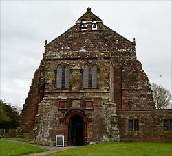
Buildings

The buildings are constructed of red sandstone from the other side of the Solway. Archaeological excavations from 2006 onwards have shown that the monastic buildings extended to the south of the church, and followed the usual Cistercian pattern. The church was along the north side of the cloister, with other buildings on the other three sides, the refectory being opposite the church and the chapter house to the west. [4] The former abbey church underwent a series of structural accidents (such as the collapse of the tower in 1600) and alterations as a result of which it gradually shrank to comprise the first six bays of the nave, without aisles. In addition the roof was lowered to the height of a single storey and there were two energetic restorations in 1883 and 1913. This nevertheless left a large enough building to continue to serve to the present day as the parish church of Abbeytown.

Fire and restoration

The church was severely damaged by arson on 9 June 2006, when original records of the monastery, including the cartulary, were destroyed. [5] It took over nine years to complete repair work to the abbey, but it was eventually fully restored and reopened to the public in September 2015. From the time of the arson attack until the reopening, parishioners worshipped in one of the side rooms which had been left undamaged. Also in September 2015, a further archaeological dig was being conducted in the grounds. [6]

Burials

Earl of Carrick stone, Holme Abbey Earl of carrick stone holme abbey.jpg
Earl of Carrick stone, Holme Abbey

See also

Sources

Related Research Articles

<span class="mw-page-title-main">Abbeytown</span> Human settlement in England

Abbeytown, also known as Holme Abbey, is a village and civil parish in the Allerdale borough of Cumbria, England.

<span class="mw-page-title-main">Bromfield, Cumbria</span> Village and civil parish in England

Bromfield is a village and civil parish in the Allerdale district of Cumbria, in the north of England.

<span class="mw-page-title-main">Aldoth</span> A hamlet in Cumbria, England

Aldoth is a hamlet in the civil parish of Holme Abbey in Cumbria, United Kingdom. It is situated approximately two-and-a-half miles south-west of Abbeytown, one-and-a-quarter miles south of Highlaws, and two-and-a-quarter miles north-east of the hamlet of Holme St. Cuthbert. Other nearby settlements include Pelutho, a mile-and-a-half to the north-west, Mawbray, four miles to the south-west, and Westnewton, three-and-three-quarter miles to the south. Cumbria's county town, Carlisle, is located twenty-and-a-half miles to the north-east.

<span class="mw-page-title-main">Blencogo</span> Human settlement in England

Blencogo is a small farming village and former civil parish near Wigton in Cumbria, England. It is situated on the Solway Plain in the Allerdale Borough Council area, off the B3502 Wigton to Silloth road. The village is a centre for growing osier willow for basketmaking and related crafts. In 1931 the parish had a population of 139.

<span class="mw-page-title-main">Mawbray</span> A village on the Cumbrian coast in England

Mawbray is a village in the civil parish of Holme St Cuthbert in the Allerdale borough of Cumbria, England. Historically part of Cumberland. It is located on the Solway Plain, 5.2 miles (8.4 km) south west of Silloth, 7.9 miles (12.7 km) north of Maryport, and 25 miles (40 km) west of Carlisle. The B5300, known locally as the "coast road" runs to the west of the village.

Holme Abbey can refer to:

<span class="mw-page-title-main">Newton Arlosh</span> Human settlement in England

Newton Arlosh is a village in the civil parish of Holme East Waver in Cumbria, United Kingdom.

<span class="mw-page-title-main">St John the Evangelist's Church, Newton Arlosh</span> Church in Cumbria, England

St John the Evangelist's Church is in the village of Newton Arlosh, Cumbria, England. It is an active Anglican parish church in the deanery of Carlisle, the archdeaconry of Carlisle, and the diocese of Carlisle. It was built as a fortified church, one of a number of such buildings near the Scottish border. It was restored and extended in the 19th century. The church is recorded in the National Heritage List for England as a designated Grade I listed building.

<span class="mw-page-title-main">Holme St Cuthbert</span> A civil parish in Cumbria, England

Holme St Cuthbert is a small village and civil parish in the borough of Allerdale, in the county of Cumbria, United Kingdom. The village is located approximately 23 miles to the south-west of Carlisle, Cumbria's county town, and was historically in the county of Cumberland.

Moss Side, Cumbria Human settlement in England

Moss Side is a hamlet on the B5307 road, in the civil parish of Holme East Waver in Cumbria, United Kingdom. Nearby settlements include the villages of Abbeytown and Newton Arlosh.

<span class="mw-page-title-main">St Mary's Church, Abbeytown</span> Church in Cumbria, England

St Mary's Church is in the village of Abbeytown, Cumbria, England. It is an active Anglican parish church in the deanery of Solway, the archdeaconry of West Cumberland, and the diocese of Carlisle. Its benefice is united with those of six local churches to form the Solway Plain Team Ministry. The church is recorded in the National Heritage List for England as a designated Grade I listed building.

<span class="mw-page-title-main">Newtown, Allerdale</span> A hamlet in Cumbria, England

Newtown is a hamlet in the civil parish of Holme St Cuthbert in Cumbria, United Kingdom. It is located approximately two miles north-east of the village of Mawbray, a little over half-a-mile as the crow flies to the south-east of Beckfoot, and twenty-five miles west of the city of Carlisle. The B5300 coast road runs approximately three-quarters of a mile to the west of the hamlet, which goes to Maryport, nine-and-a-quarter miles to the south-west, and Silloth-on-Solway, approximately four miles to the north.

<span class="mw-page-title-main">Holme Low</span> A civil parish in Cumbria, England

Holme Low is a civil parish in the Allerdale borough of Cumbria, United Kingdom. It borders the parishes of Holme St. Cuthbert and Holme Abbey to the south, the town of Silloth-on-Solway to the north-west, and has a short stretch of coastline on the Solway Firth to the west. To the north, it is bordered by lands common to Holme St. Cuthbert, Holme Low, and Holme Abbey, which is an unpopulated area. Holme Low had a population of 373 in 137 households at the 2001 census, reducing slightly in the 2011 Census to a population of 362 in 162 households.

<span class="mw-page-title-main">Tarns, Cumbria</span> A settlement in Cumbria, England

Tarns is a small farming settlement in the civil parish of Holme St. Cuthbert in Cumbria, United Kingdom. It is located two miles north-east of the village of Mawbray, and twenty-three miles south-west of Carlisle, Cumbria's county town. The B5301 road runs through the settlement, and along that road the town of Silloth-on-Solway is located five-and-a-half miles to the north, and Aspatria four-and-a-half miles to the south-east. Other nearby settlements include Aikshaw, Goodyhills, Jericho, and New Cowper.

<span class="mw-page-title-main">B5302 road</span> A road in Cumbria, England

The B5302 is a B road which runs for approximately twelve-and-a-quarter miles between the towns of Silloth-on-Solway and Wigton in Cumbria, United Kingdom. From west to east, it passes through the villages of Causewayhead, Calvo, Abbeytown, Wheyrigg, and Waverbridge, and also passes near to Blackdyke and Blencogo. At its eastern end, it comes very close to the Solway Coast Area of Outstanding Natural Beauty, and passes by Silloth Airfield, left over from the Second World War. Several of the villages that the road passes through were formerly served by trains on the single-track Carlisle and Silloth Bay Railway, which closed with the Beeching axe in the 1960s. It is the main road connecting Silloth-on-Solway and surrounding settlements with the A596, and by extension, the city of Carlisle.

<span class="mw-page-title-main">Holme East Waver</span> A civil parish in Cumbria, England

Holme East Waver is a civil parish in the Allerdale borough of Cumbria, United Kingdom. It is bordered to the north by the civil parish of Bowness-on-Solway, to the east by the civil parishes of Kirkbride, Woodside, and Waverton, and to the south by the civil parishes of Dundraw and Holme Abbey, lands common to Holme St. Cuthbert, Holme Low, and Holme Abbey, and the town of Silloth-on-Solway. At the 2001 census, it had a population of 306 in 121 households, increasing slightly at the 2011 Census to a population of 318 in 130 households. It is named for the River Waver, and the rivers Waver and Wampool enter the Solway Firth at the western end of the parish. Part of the Solway Coast Area of Outstanding Natural Beauty is within the parish of Holme East Waver. The largest village is Newton Arlosh.

<span class="mw-page-title-main">Highlaws</span> A hamlet in Cumbria, England

Highlaws is a hamlet in the civil parish of Holme Abbey in Cumbria, United Kingdom. It is situated approximately two-and-a-quarter miles south-west of Abbeytown, one-and-a-half miles east of Pelutho, and one mile to the north of Aldoth. Other nearby settlements include Mawbray, four-and-a-quarter miles to the south-west, Blitterlees, three miles to the north-west, Blackdyke, two-and-a-quarter miles due north, and Foulsyke. Carlisle, Cumbria's county town, is located twenty miles to the north-east.

Holme Abbey is a civil parish in the Borough of Allerdale in Cumbria, England. It contains 15 listed buildings that are recorded in the National Heritage List for England. Of these, one is listed at Grade I, the highest of the three grades, one is at Grade II*, the middle grade, and the others are at Grade II, the lowest grade. The parish contains the village of Abbeytown and smaller settlements, and is otherwise rural. The most important building in the parish was Holmcultram Abbey part of which has been converted into a parish church, and other parts have been used in other buildings. Most of the other listed buildings are houses and associated structures, farmhouses and farm buildings.

<span class="mw-page-title-main">Kelsick</span> A hamlet in Cumbria, England

Kelsick is a hamlet in the civil parish of Dundraw in Cumbria, United Kingdom. It is located approximately 1.8 miles (2.9 km) southeast of Abbeytown, 0.9 miles (1.4 km) northwest of Dundraw, and 14.5 miles (23.3 km) west of Carlisle, Cumbria's county town. Kelsick is accessed by two side-roads off the B5302 road, which runs between Silloth and Wigton.

References

  1. 'Records: The foundation and growth to 1200', in "Register and Records of Holme Cultram", ed. Francis Grainger and W G Collingwood (Kendal, 1929), pp. 117-126. British History Online
  2. Brooke, Daphne, "Wild Men and Holy Places". Canongate Books 1994
  3. Salmon, M., "A history of St John's Church, Newton Arlosh". Information leaflet 1991
  4. West Cumbria Archaeological Society, "Archaeological Investigations 2006—2010". Information leaflet 2011
  5. www.theguardian.com
  6. "BBC News: Holme Cultram St Mary Abbey open nine years after arson attack". BBC News. 26 September 2015. Retrieved 27 September 2015.

Coordinates: 54°50′43″N3°16′58″W / 54.8454°N 3.2829°W / 54.8454; -3.2829