
Burnley is a town and the administrative centre of the wider Borough of Burnley in Lancashire, England, with a 2001 population of 73,021. It is 21 miles (34 km) north of Manchester and 20 miles (32 km) east of Preston, at the confluence of the River Calder and River Brun.

The Borough of Burnley is a local government district with the borough status in Lancashire, England. It has an area of 42.7 square miles (110.7 km2) and a population of 94,646 (2021), and is named after its largest town, Burnley. Other notable settlements include Padiham, Hapton, Worsthorne, Briercliffe and Cliviger.

Towneley Park is owned and managed by Burnley Borough Council and is the largest and most popular park in Burnley, Lancashire, England. The main entrance to the park is within a mile of the town centre and the park extends to the south east, covering an area of some 180 hectares. At the southern end of the park is Towneley Hall, Burnley's art gallery and museum. To the north are golf courses and playing fields and to the south 24 acres of broadleaf woodland. On the southern boundary is a working farm called Towneley Farm with pastures and plantations extending eastwards into Cliviger.
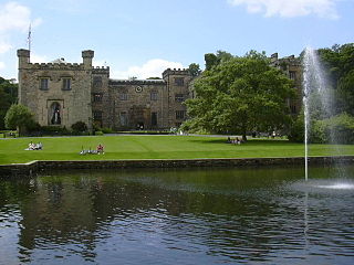
Gawthorpe Hall is an Elizabethan country house on the banks of the River Calder, in Ightenhill, a civil parish in the Borough of Burnley, Lancashire, England. Its estate extends into Padiham, with the Stockbridge Drive entrance situated there. The house is traditionally attributed to Robert Smythson. In the mid-19th century, the hall was rebuilt by Charles Barry, the architect of the Houses of Parliament. Since 1953 it has been designated a Grade I listed building. In 1970 the 4th Lord Shuttleworth gave the hall to the National Trust, with a 99-year lease to Lancashire County Council. Both bodies jointly administer the hall and in 2015 the council provided £500,000 funding for restoration work on the south and west sides of the house.
Burnley was a Rural district of Lancashire, England from 1894 to 1974. It was named after but did not include the large town of Burnley, which was a county borough.

The River Calder is a major tributary of the River Ribble in Lancashire, England and is around 20 miles (32 km) in length.

Cliviger is a civil parish in the Borough of Burnley, in Lancashire, England. It is situated to the southeast of Burnley, and northwest of Todmorden. According to the 2011 census, the parish has a population of 2,238.

Worsthorne is a rural village on the eastern outskirts of Burnley in Lancashire, England. It is in the civil parish of Worsthorne-with-Hurstwood and the borough of Burnley. At the 2011 census the village had a population of 1,028.

The Burnley Way is a 40-mile (64 km) long distance footpath in Lancashire, England. As a circular walk it can be walked from any point, but it is common to start and finish at the Weavers' Triangle Visitor Centre in Burnley. It covers a range of terrain from canal towpaths to open moorland.

Habergham Eaves is a civil parish in the borough of Burnley, in Lancashire, England. The parish consists of a rural area south of Burnley, and suburban areas on the outskirts of the town, including a large industrial estate in the north-west corner of the parish. Habergham is also the name of an area west of Burnley, although it is no longer within the parish. According to the United Kingdom Census 2011, the parish has a population of 1,466.

Worsthorne-with-Hurstwood is a civil parish in the Borough of Burnley, in Lancashire, England. Situated on the eastern outskirts of Burnley, in 2011 it had a population of 2,963.
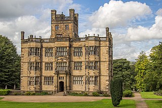
The Towneley or Townley family are an English (UK) family whose ancestry can be traced back to Anglo-Saxon England. Towneley Hall in Burnley, Lancashire, was the family seat until its sale, together with the surrounding park, to the corporation of Burnley in 1901. Towneley Hall is now a Grade I listed building and a large museum and art gallery within Towneley Park (UK).
The Weavers' Triangle is an area of Burnley in Lancashire, England consisting mostly of 19th-century industrial buildings at the western side of town centre clustered around the Leeds and Liverpool Canal. The area has significant historic interest as the cotton mills and associated buildings encapsulate the social and economic development of the town and its weaving industry. From the 1980s, the area has been the focus of major redevelopment efforts.
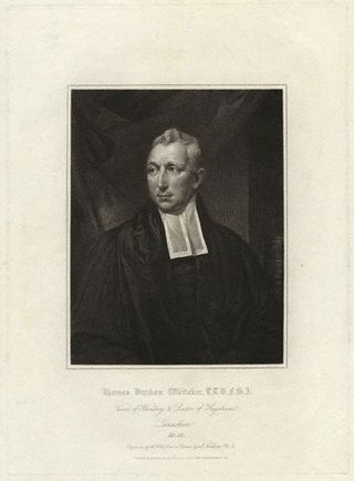
Thomas Dunham Whitaker (1759–1821) was an English clergyman and topographer.

Gisburne Park is an 18th-century country house and associated park in Gisburn, Lancashire, England, in the Ribble Valley some 6 miles (10 km) north-east of Clitheroe. The house is a Grade I listed building, and is now privately owned by Amber and Guy Hindley. The associated 1,000 acre park is Grade II listed, and is partly traditional agricultural estate and partly a holiday and wedding destination.
Cliviger is a civil parish in the borough of Burnley, Lancashire, England. The parish contains 22 listed buildings that are recorded in the National Heritage List for England. Of these, two are listed at Grade II*, the middle grade, and the others are at Grade II, the lowest grade. Apart from small settlements, the parish is rural, and most of the listed buildings are or have been farmhouses, farm buildings, and associated structures. Also in the parish are large houses, a parish church, the base of a cross, a public house, two war memorials, and two boundary stones.
Worsthorne-with-Hurstwood is a civil parish in the borough of Burnley, Lancashire, England. The parish contains 22 buildings that are recorded in the National Heritage List for England as designated listed buildings. Of these, four are listed at Grade II*, the middle grade, and the others are at Grade II, the lowest grade. Apart from the village of Worsthorne and the settlement of Hurstwood, the parish is rural. Most of the listed buildings are farmhouses, or originated as farmhouses or farm buildings. Other listed buildings include large houses and associated structures, a row of former back-to-back cottages, a church, and a telephone kiosk.

The Church of St John the Divine is in Burnley Road, Holme Chapel, a village in the civil parish of Cliviger, near Burnley, Lancashire, England. It is an active Anglican parish church in the diocese of Blackburn, and the church is recorded in the National Heritage List for England as a designated Grade II listed building. It was built between 1788 and 1794, replacing a small chapel, and is in simple Classical style. Above the west front is a bell turret with an octagonal cupola, and inside the church are carved oak stalls, moved from a demolished church, which include a poppyhead and misericords.
Hurstwood is a rural hamlet on the eastern outskirts of Burnley in Lancashire, England. It is in the civil parish of Worsthorne-with-Hurstwood and the borough of Burnley.


