Birkerød is a town in Rudersdal Municipality in the northern outskirts of Copenhagen, Denmark. It is surrounded by several lakes and small woodlands. Birkerød station is located on the Hillerød radial of the S-train suburban network.
Lyngby-Taarbæk Municipality is a municipality in the Capital Region of Denmark near Copenhagen on the eastern coast of the island of Zealand. It is part of the Greater Copenhagen area. The municipality borders Rudersdal Municipality to the north, Furesø Municipality to the west and Gladsaxe and Gentofte Municipality to the south. It borders the Øresund to the east.
Until 1 January 2007 Søllerød was a municipality in Copenhagen County on the east coast of the island of Zealand (Sjælland) in eastern Denmark. The municipality covered an area of 39.77 km², and had a total population of 31,920 (2006). Its mayor was Erik Fabrin, a member of the Venstre political party.
Hørsholm is an urban area on the Øresund coast approximately 25 km (15.53 mi) north of Copenhagen, Denmark. It covers most of Hørsholm Municipality and straddles the borders neighbouring Fredensborg Municipality and Rudersdal Municipality.

Virum is a mostly residential, suburban neighbourhood in Lyngby-Taarbæk Municipality, located on both sides of Lyngby Kongevej, approximately 15 km north of central Copenhagen, Denmark. The neighbourhood is bordered by Lake Furesø to the west, Holte in Rudersdal Municipality to the north, Brede to the east and Kongens Lyngby and Sorgenfri to the south.

Rudersdal Municipality is a part suburban, part rural municipality located on the northern outskirts of Copenhagen, Denmark. It covers an area of 73 km² and has a population of 57,193. The distance from Copenhagen City Hall Square is approximately 20 km. The western part of the municipality is served by the Hillerød radial of the S-train network while the eastern part is served by the Coast Line. Administratively Rudersdal Municipality belongs to Region Hovedstaden.

Valby ( ) is one of the 10 official districts of Copenhagen Municipality, Denmark. It is in the southwestern corner of Copenhagen Municipality, and has a mixture of different types of housing. This includes apartment blocks, terraced housing, areas with single-family houses and allotments, plus the remaining part of the old Valby village, around which the district has formed, intermingled with past and present industrial sites.
Vedbæk is a wealthy suburban neighbourhood on the coast north of Copenhagen, Denmark. It belongs to Rudersdal Municipality and has merged with the town of Hørsholm to the north. The area has been inhabited for at least 7,000 years, as evidenced by the discovery of a Mesolithic cemetery of the Ertebølle culture. By the 16th century, there were a few small farms and fishermen's houses on the site and in the 18th century, well-to-do townsfolk from Copenhagen started to build country houses in the area. After a paddle steamer began to call at Vedbæk on its journey from Copenhagen to Helsingør, there was an influx of visitors. There are a number of large country houses and a historic church. There has been a railway station for some time and there are popular sandy beaches to the north and south. Enrum Forest is open to the public and provides recreational facilities.

Harlev is a former railway town in Aarhus Municipality in Denmark, with a population of 3,990 as of 1 January 2023. It is a suburb only 13 kilometres west of central Aarhus and is located at the Danish national road 15.
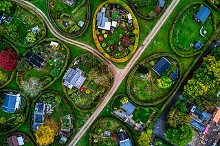
Nærum is a suburban district in Rudersdal Municipality in the north outskirts of Copenhagen, Denmark. Quartered by the Helsingør Motorway running north–south and Skodsborgvej running east–west, Nærum is bounded by Jægersborg Hegn on the south and east, Geel's Forest on the west, open fields on the north and the Søllerød district on the northwest. 5230 people live in the parish of Nærum, most of them in low-rise concrete blocks or single-family houses.
Trørød is a suburban district in Rudersdal Municipality, located approximately 20 kilometres north of central Copenhagen, Denmark. The original village has merged with the neighbouring communities of Vedbæk and Gammel Holte and now form the southernmost part of the urban agglomeration of Hørsholm. It is on the other sides surrounded by open farmland and the forests Jægersborg Hegn, Kohave Forest and Trørød Forest.

Værløse is a town in Furesø Municipality in the northwestern outskirts of Copenhagen, Denmark. As of 1 January 2023, it has a population of 13,203. Situated on the west side of the Hillerød Motorway, between Farum Lake to the north and Søndersø Lake to the south, it is surrounded by forest on three sides. Modern Værløse emerged around Værløse station in the 1950s. The original centre of the parish was the village of Kirke Værløse, located three kilometres to the west. The two communities have now almost merged.

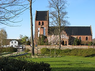
Søllerød is a suburban district of Rudersdal Municipality in the northern outskirts of Copenhagen, Denmark. The original village, one of the oldest in the area, is perched on Søllerød Hill on the south side of Søllerød Lake. It merged with the neighbouring village of Øverød to the north and the modern district of Holte to the southwest in the middle of the 20th century and now forms part of the Greater Copenhagen area.
Øverød is a suburban neighborhood situated on the north side of Søllerød Lake in Holte, Rudersdal Municipality, in the northern outskirts of Copenhagen, Denmark. The original village is now agglomerated with the modern district of Holte and the village of Søllerød, forming the northernmost part of Copenhagen's urban area. Øverød is bounded by Rude Forest on the west and Søllerød Naturpark on the east. It belongs to Holte postal district.

Gl. Holtegaard is a former Manor house in Rudersdal Municipality north of Copenhagen, Denmark, today operated as an arts centre and a museum. It was built by the Danish Baroque architect Lauritz de Thurah (1706–1759), for his own use in 1757. Its original Baroque gardens were reconstructed in 2003.

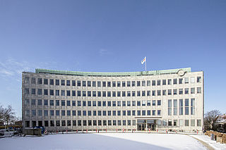
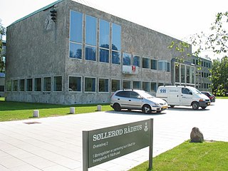
Søllerød Town Hall, now renamed Rudersdal Town Hall, was built for the former Søllerød Municipality which in 2007 became part of Rudersdal Municipality, combining Søllerød and Birkerød. The building is located in Holte some 19 km to the north of Copenhagen's city centre. Designed by Danish architects Arne Jacobsen and Flemming Lassen, it was completed in 1942.
Søllerød Naturpark is a protected area of rolling fields, meadows and small woods in Rudersdal Municipality, some 20 kilometres north of central Copenhagen, Denmark. It reaches from Søllerød Kirkeskov in the south to Høje Sandbjerg in the north. The area is state-owned and managed by the Danish Nature Agency.

Mothsgården is a former country retreat in Søllerød in the northern suburbs of Copenhagen, Denmark. It now houses the main branch of Rudersdal Museum, a local history museum for Rudersdal Municipality. The museum also comprises the Vedbæk Finds, a collection of archeological finds from Vedbæk, now on display in Gammel Holtegård, and the Rudersdal Local Historic Archives in Rudersdal Library.

Secondary route 201 is a numbered road in North Zealand to the north of Copenhagen, Denmark, consisting of Lyngby Omfartsvej, a motorway bypass avoiding Lyngby Hovedgade, and Kongevejen which links Kongens Lyngby in the south with Hillerød in the north by way of Holte, Birkerød and Blovstrød. The road originates in a royal road which was built in 1587 between Copenhagen and Frederiksborg Castle, Frederick II's new North Zealand residence. The southern part of the road has now been replaced by Lyngbyvej and the southernmost portion of Helsingør Motorway.

Sjælsø is a lake straddling the borders between the municipalities of Rudersdal, Allerød and Hørsholm in North Zealand to the north of Copenhagen, Denmark. Situated immediately to the north of the suburban town of Birkerød, it is surrounded by a mixture of farmland, pastures and small woodlands.


