
Glamorgan, or sometimes Glamorganshire, is one of the thirteen historic counties of Wales and a former administrative county of Wales. Originally an early medieval petty kingdom of varying boundaries known in Welsh as the Kingdom of Morgannwg, which was then invaded and taken over by the Normans as the Lordship of Glamorgan. The area that became known as Glamorgan was both a rural, pastoral area, and a conflict point between the Norman lords and the Welsh princes. It was defined by a large concentration of castles.

Baglan is a large village in Wales, adjoining Port Talbot, named after Saint Baglan. Baglan is also a community and ward in the Neath Port Talbot county borough. In 2001, the population was 6,654. rising to 6,819 in 2011.
Brynford is a village and community in Flintshire, Wales. It is located to the south west of the town of Holywell and near the A55 road. Brynford had a population of 1,059 at the 2011 census.

Llanfyllin is a market town, community and electoral ward in a sparsely populated area in Montgomeryshire, Powys, Wales. Llanfyllin's community population in 2011 was 1,532, of whom 34.1% could speak Welsh. Llanfyllin means church or parish (llan) of St Myllin. The community includes the tiny settlements of Bodfach, Ty Crwyn, Abernaint and several farms.

Parc Cwm long cairn, also known as Parc le Breos burial chamber, is a partly restored Neolithic chambered tomb, identified in 1937 as a Severn-Cotswold type of chambered long barrow. The cromlech, a megalithic burial chamber, was built around 5850 years before present (BP), during the early Neolithic. It is about seven 1⁄2 miles (12 km) west south–west of Swansea, Wales, in what is now known as Coed y Parc Cwm at Parc le Breos, on the Gower Peninsula.

Wenvoe Castle was a castle and country estate between Barry and Wenvoe, in the Vale of Glamorgan, south Wales. Today the former estate forms the Wenvoe Castle Golf Club. Goldsland lies on its western boundary.

Monk Street is an historic street in the town of Monmouth, Monmouthshire, Wales. A portion of it was in existence by the 14th century, and appears on the 1610 map of the town by cartographer John Speed. It runs in a north-south direction, extending northward from its intersection with Whitecross Street. The name of the street relates to the nearby Priory, as well as the gate which was originally on this road and provided part of the town's defences, Monk's Gate. Monk Street is lined with numerous listed buildings.

Kingsley House and Hendre House are a pair of 19th-century, semi-detached houses on the North Parade section of Monk Street in Monmouth, Monmouthshire, Wales. The grade II listed houses were designed by noted Monmouth architect and builder George Vaughan Maddox, who also designed at least two of the twenty-four blue plaque buildings on the Monmouth Heritage Trail, including the Market Hall and the Monmouth Methodist Church. Hendre House should be distinguished from The Hendre, the estate of the Rolls family.
Glendower Street is a historic street in the town centre of Monmouth, Monmouthshire, Wales. It extends to the southeast from the intersection of Agincourt Street and St John's Street, within the medieval town walls. Glendower Street is lined with numerous listed buildings, including one of the 24 blue plaque buildings on the Monmouth Heritage Trail.

Bro Machno is a community in Conwy County Borough, in Wales, formed from the former civil parish of Penmachno. It covers the Penmachno Valley, through which runs the Afon Machno, and includes the villages of Penmachno and Cwm Penmachno. To the south west borders Gwynedd, and is located 4.8 miles (7.7 km) south of Betws-y-Coed, 21.8 miles (35.1 km) north west of Corwen, and 19.4 miles (31.2 km) south of Conwy. The whole of the community is within the Snowdonia national park, while much of it forms part of Gwydir Forest. According to the 2011 census, the population of the Bro Machno Parish was 617, of whom 342 (55%) were able to speak Welsh and 214 (34%) had no skills in Welsh.
Cwmsychbant is a small village in the community of Llanwenog, Ceredigion, Wales, on the A475 road. Cwmsychbant is represented in the Senedd by Elin Jones and the Member of Parliament is Ben Lake.

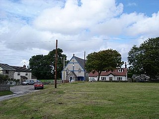
St Michael's Church, also known as Brynford Parish Church, is a Grade II listed Church in Wales church in Brynford, Flintshire, northeast Wales, to the southwest of Holywell. The foundation stone was laid by the Bishop of St. Asaph on 6 October 1851, and it was consecrated on 12 July 1853. The architect was Thomas Henry Wyatt. It is designated as a Grade II listed building

Scleddau is a village and a community in the county of Pembrokeshire, Wales, and is 2 miles (3.2 km) south of Fishguard on the main A40 road. The Western Cleddau river which lends its name to the village flows under the main road. There are several springs in the village.

Hill's Tramroad was a 2 feet (0.61 m) gauge plateway for horse-drawn trams that connected the Blaenavon Ironworks to Llanfoist on the Brecknock and Abergavenny Canal. It ran through the Pwll Du Tunnel, past the Tyla and Pwll Du quarries, through Garnddyrys Forge and on to the Llanfoist wharf. The tramroad from Pwll Du to Llanfoist was abandoned in 1861 after the railway reached Blaenavon and Garnddyrys Forge was abandoned.

Pwll Du was a village in Monmouthshire, Wales. It was declared a slum in 1960 and demolished in 1963. The main employment was provided by nearby limestone quarries and by the iron works in Blaenavon. The Pwll Du Tunnel from Blaenavon, once the longest horse-powered tramway in Britain, ended near the village. A pub and the former Welfare Hall, now a school's outdoor pursuits centre, are all that are left standing.

Bedd-y-Cawr Hillfort, or Bedd y Cawr Hillfort, is an Iron Age hillfort on a natural inland promontory in the community of Cefnmeiriadog in Denbighshire in North Wales. The name of the hillfort translates from the Welsh as Giant's Tomb.
Caer Bach is a Welsh hillfort of indeterminate age, on a rounded hillock situated near the village of Rowen; in Conwy County, North Wales. Its name in English translates as 'Small Fort'; or alternatively 'Little Fortress'. It is situated on the Eastern slopes of Tal-y-Fan, an outlying peak of the Carneddau mountain range in northeast Snowdonia; at an altitude of approximately 413 metres. Little information is known about the history of the fort, as to date, the site has undergone minimal investigation. The fort is classed as a scheduled ancient monument and is of national importance for its potential to enhance our knowledge of prehistoric settlement. It is said to retain significant archaeological potential, with a strong probability of the presence of associated archaeological features and deposits.
