
The Yangtze or Yangzi is the longest river in Eurasia, the third-longest in the world, and the longest in the world to flow entirely within one country. It rises at Jari Hill in the Tanggula Mountains of the Tibetan Plateau and flows 6,300 km (3,915 mi) in a generally easterly direction to the East China Sea. It is the fifth-largest primary river by discharge volume in the world. Its drainage basin comprises one-fifth of the land area of China, and is home to nearly one-third of the country's population.

China has great physical diversity. The eastern plains and southern coasts of the country consist of fertile lowlands and foothills. They are the location of most of China's agricultural output and human population. The southern areas of the country consist of hilly and mountainous terrain. The west and north of the country are dominated by sunken basins, rolling plateaus, and towering massifs. It contains part of the highest tableland on earth, the Tibetan Plateau, and has much lower agricultural potential and population.

A valley is an elongated low area often running between hills or mountains, which will typically contain a river or stream running from one end to the other. Most valleys are formed by erosion of the land surface by rivers or streams over a very long period. Some valleys are formed through erosion by glacial ice. These glaciers may remain present in valleys in high mountains or polar areas.

Lake Chad is a freshwater lake located at the junction of Nigeria, Niger, Chad and Cameroon in central and western Africa. It is also an important wetland ecosystem in West Africa. The catchment area of Lake Chad is 1 million square kilometers. It used to be a large lake with an area of 28,000 square kilometers in the 19th century. However, due to climate change and human water diversion, Lake Chad has been greatly reduced since the mid-1970s, and its area has fluctuated between 2,000 and 5,000 square kilometers.

A sinkhole is a depression or hole in the ground caused by some form of collapse of the surface layer. The term is sometimes used to refer to doline, enclosed depressions that are locally also known as vrtače and shakeholes, and to openings where surface water enters into underground passages known as ponor, swallow hole or swallet. A cenote is a type of sinkhole that exposes groundwater underneath. Sink and stream sink are more general terms for sites that drain surface water, possibly by infiltration into sediment or crumbled rock.

A drainage basin is an area of land where all flowing surface water converges to a single point, such as a river mouth, or flows into another body of water, such as a lake or ocean. A basin is separated from adjacent basins by a perimeter, the drainage divide, made up of a succession of elevated features, such as ridges and hills. A basin may consist of smaller basins that merge at river confluences, forming a hierarchical pattern.

The Salween is a Southeast Asian river, about 3,289 kilometres (2,044 mi) long, flowing from the Tibetan Plateau south into the Andaman Sea. The Salween flows primarily within southwest China and eastern Myanmar (Burma), with a short section forming the border of Burma and Thailand. Throughout most of its course, it runs swiftly through rugged mountain canyons. Despite the river's great length, only the last 90 km (56 mi) are navigable, where it forms a modest estuary and delta at Mawlamyine. The river is known by various names along its course, including Thanlwin in Burma and Nu Jiang in China. The commonly used spelling "Salween" is an anglicisation of the Burmese name dating from 19th-century British maps.

Dongting Lake is a large, shallow lake in northeastern Hunan Province, China. It is a flood basin of the Yangtze River, so its volume depends on the season. The provinces of Hubei and Hunan are named after their location relative to the lake: Hubei means "North of the Lake" and Hunan, "South of the Lake".

The Xiang River is the chief river of the Lake Dongting drainage system of the middle Yangtze, the largest river in Hunan Province, China. It is the 2nd largest tributary in terms of surface runoff, the 5th largest tributary by drainage area of the Yangtze tributaries. The river flows generally northeast through the provinces of Guangxi and Hunan, its tributaries reaching into Jiangxi and Guangdong.

Magdalena is a department of Colombia with more than 1.3 million people, located to the north of the country by the Caribbean Sea. The capital of the Magdalena Department is Santa Marta and was named after the Magdalena River. It inherited the name of one of the original nine states of the United States of Colombia that its current territory integrated.

The Li River or Li Jiang is the name for the upper reaches of the Gui River in northwestern Guangxi, China. It is part of the Xijiang River system in the Pearl River basin, flowing 164 kilometres (102 mi) from Xing'an County to Pingle County.

The Huai River, formerly romanized as the Hwai, is a major river in China. It is located about midway between the Yellow River and Yangtze, the two longest rivers and largest drainage basins in China, and like them runs from west to east. Historically draining directly into the Yellow Sea, floods have changed the course of the river such that it now primarily discharges into the Yangtze. The Huai is notoriously vulnerable to flooding.
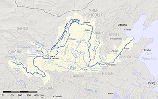
The Fen River drains the center of Shanxi Province, China. It originates in the Guancen Mountains of Ningwu County in northeast Shanxi, flows southeast into the basin of Taiyuan, and then south through the central valley of Shanxi before turning west to join the Yellow River west of Hejin. The Fen and the Wei Rivers are the two largest tributaries of the Yellow River. The river is 694 kilometers (431 mi) long and drains an area of 39,417 km2 (15,219 sq mi), 25.3% of Shanxi's area. The Fen River is the longest in Shanxi. It is also the second-longest tributary of the Yellow River. Within Taiyuan, the Fen runs from north to south; the prefecture includes one-seventh of the river's course.
The Rainwater Basin wetland region is a 4,200 sq mi (11,000 km2) loess plain located south of the Platte River in south-central Nebraska. It lies principally in Adams, Butler, Clay, Fillmore, Hamilton, Kearney, Phelps, Polk, Saline, Seward, and York counties and extends into adjacent areas of southeastern Hall, northern Franklin, northern Nuckolls, western Saline, northern Thayer and northwestern Webster counties. Before European settlement, this plain was covered by prairie grasslands interspersed with thousands of ephemeral playa wetlands, called Rainwater Basins. Informally and locally, individual Nebraska Rainwater Basins are referred to as rainbasins, basins, lagoons, lakes, ponds, marshes, hay marshes, and lakes marshes. To the west, a tallgrass prairie in the east once gradually transitioned into mixed grass prairie. Currently, the Rainwater Basin wetland region is covered by farms, mainly growing corn and soybeans. Several, interspersed, stream courses, of which largest is the Big Blue River and its tributaries, drain this region. Riparian woodlands and upland slopes possessing oak woodlands are associated with these streams. In the spring and fall months, millions of migratory birds pass through the region to feed and rest. Along with riparian habitats associated Platte River, Big Blue River, its tributaries, and smaller streams, Rainwater Basins are a major component of the Central Flyway of North America.

The Red Rock River is a roughly 70-mile (110 km) river in southwestern Montana in the United States. Its drainage basin covers over 1,548 square miles (4,010 km2). Its furthest tributary, Hell Roaring Creek, originates in the Beaverhead National Forest within a few hundred meters of the North American Continental Divide and Montana-Idaho border near Brower's Spring, at an elevation of about 9,100 feet (2,800 m). Brower's Spring is near the furthest headwaters of the Missouri River, one of the major watercourses of the central United States. As such, it is also the furthest headwaters of the entire Missouri-Mississippi river system, today the fourth longest river on earth and once the third-longest.

The Three Parallel Rivers of Yunnan Protected Areas is a UNESCO World Heritage Site in Yunnan province, China. It lies within the drainage basins of the upper reaches of the Jinsha (Yangtze), Lancang (Mekong) and Nujiang (Salween) rivers, in the Yunnan section of the Hengduan Mountains.

Interbasin transfer or transbasin diversion are terms used to describe man-made conveyance schemes which move water from one river basin where it is available, to another basin where water is less available or could be utilized better for human development. The purpose of such water resource engineering schemes can be to alleviate water shortages in the receiving basin, to generate electricity, or both. Rarely, as in the case of the Glory River which diverted water from the Tigris to Euphrates River in modern Iraq, interbasin transfers have been undertaken for political purposes. While ancient water supply examples exist, the first modern developments were undertaken in the 19th century in Australia, India and the United States, feeding large cities such as Denver and Los Angeles. Since the 20th century many more similar projects have followed in other countries, including Israel and China, and contributions to the Green Revolution in India and hydropower development in Canada.
The Nambung River is a river in the Wheatbelt region of Western Australia, 170 kilometres (106 mi) north of Perth. The river drains an area between the towns of Cervantes and Badgingarra. In its lower reaches the Nambung River forms a chain of waterholes in the Nambung Wetlands where it disappears underground into a limestone karst system 5.5 kilometres (3 mi) from the Indian Ocean.

The Daba Mountains, also known by their Chinese name as the Dabashan, are a mountain range in Central China between the watersheds of the Yellow and Yangtze Rivers. Part of the larger Qinling mountain range, it cuts through four provinces: Sichuan, Chongqing, Shaanxi, and Hubei. It is about 1,000 kilometers (620 mi) long.
Twelve Views of Bayu are popular scenic views in and around the city of Chongqing, China. Ba and Yu are old names of Chongqing in Imperial times. Influenced by Eight Views of Xiaoxiang in Hunan Province, people in Chongqing listed their own most beloved views during the reign of the Tianshun Emperor of the Ming dynasty. Scenic views in the list changed throughout the history. Some scenic views appeared in earlier lists no longer exist in modern days due to the change of physical geography, landscapes and land-uses.