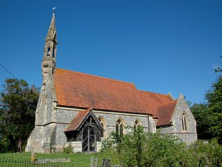
Adwell is a village and civil parish about 3 miles (5 km) south of Thame in South Oxfordshire. The parish covers 443 acres (179 ha),
Robert D'Oyly was a Norman nobleman who accompanied William the Conqueror on the Norman conquest, his invasion of England. He died in 1091.

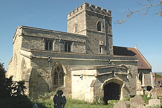
Aston Rowant is a village, civil parish and former manor about 4+1⁄2 miles (7 km) south of Thame in South Oxfordshire, England. The parish includes the villages of Aston Rowant and Kingston Blount, and adjoins Buckinghamshire to the southeast. The 2011 Census recorded the parish's population as 793. The Lower Icknield Way passes through the parish southeast of the village.
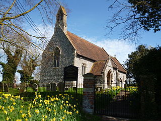
Britwell Salome is a village and civil parish in South Oxfordshire, England centred 4+1⁄2 miles (7 km) northeast of Wallingford. The 2011 Census recorded the parish's population as 204.

Cassington is a village and civil parish in Oxfordshire about 5 miles (8 km) northwest of Oxford. The village lies on gravel strata about 1⁄2 mile (800 m) from the confluence of the River Evenlode with the River Thames. The parish includes the hamlet of Worton northeast of the village and the site of the former hamlet of Somerford to the south. Somerford seems to have been abandoned early in the 14th century. Cassington is formed of two parts, "upper" and "lower", each with its own village green. The 2011 Census recorded the parish's population as 750.
Beckley is a village in the civil parish of Beckley and Stowood, in the South Oxfordshire district, in the county of Oxfordshire, England. It is about 4.5 miles (7 km) northeast of the centre of Oxford. The 2011 Census recorded the parish of Beckley and Stowood's population as 608. The village is 400 feet (120 m) above sea level on the northern brow of a hill overlooking Otmoor. The hill is the highest part of the parish, rising to 463 feet (141 m) south of the village near Stow Wood. On the eastern brow of the hill is Oxford transmitting station, a television relay mast that is a local landmark. In 1931 the parish of Beckley had a population of 288. On 1 April 1932 the parish was abolished to form "Beckley and Stowood", part also went to "Fencott and Murcott".

North Leigh is a village and civil parish about 3 miles (5 km) northeast of Witney in Oxfordshire. The parish includes the hamlet of East End and since 1932 has also included the hamlet of Wilcote. The 2011 Census recorded the parish's population as 1,929.

Warborough is a village and civil parish in South Oxfordshire, about 2.5 miles (4 km) north of Wallingford and about 9 miles (14 km) south of Oxford. The parish also includes the hamlet of Shillingford, south of Warborough beside the River Thames.

Pyrton is a small village and large civil parish in Oxfordshire about 1 mile (1.6 km) north of the small town of Watlington and 5 miles (8 km) south of Thame. The 2011 Census recorded the parish's population as 227. The toponym is from the Old English meaning "pear-tree farm".

Swyncombe is a hamlet and large civil parish in the high Chilterns, within the Area of Outstanding Natural Beauty about 4+1⁄2 miles (7 km) east of Wallingford, Oxfordshire, England. Swyncombe hamlet consists almost entirely of its Church of England parish church of Saint Botolph, the former rectory and Swyncombe House. The population of the parish is in the hamlets of Cookley Green and Russell's Water, and the scattered hamlet of Park Corner. The 2011 Census recorded the parish's population as 250. It is partially forested and is the fifth largest of 87 civil parishes in the District.
Worton is a hamlet in Cassington civil parish, 4.5 miles (7.2 km) northwest of Oxford.

Tadmarton is a village and civil parish about 4 miles (6.4 km) west of Banbury, Oxfordshire. The 2011 Census recorded the parish's population as 541, which is a 26% increase on the figure of 430 recorded by the 2001 Census.

Alkerton is a village and former civil parish, now in the parish of Shenington with Alkerton, in the Cherwell district, in the county of Oxfordshire, England. It is on the county boundary with Warwickshire, about 5 miles (8 km) west of Banbury. In 1961 the parish had a population of 82. On 1 April 1970 the parish was abolished and merged with Shenington to form "Shenington with Alkerton".
Newton Purcell is a village in the civil parish of Newton Purcell with Shelswell, in the Cherwell district, in the county of Oxfordshire, England, 4+1⁄2 miles (7 km) southeast of Brackley in neighbouring Northamptonshire. The 2001 Census recorded a parish population of 103. The parish population from the 2011 Census is not available.

Pishill with Stonor is a civil parish in the high Chilterns, South Oxfordshire. It includes the villages of Pishill and Stonor, and the hamlets of Maidensgrove and Russell's Water. Pishill with Stonor was formed by the merger of the separate civil parishes of Pishill and Stonor in 1922. In 2011 it had a human population of 304 across its 10.54 km².

Holton is a village and civil parish in South Oxfordshire about 5.5 miles (9 km) east of Oxford. The parish is bounded to the southeast by the River Thame, to the east and north by the Thame's tributary Holton Brook, to the south by London Road and to the west by field boundaries with the parishes of Forest Hill with Shotover and Stanton St John.
Mary Doreen Lobel was a historian who edited several volumes of the Victoria County History and a three-volume British Atlas of Historic Towns.
William de Courcy, feudal baron of Stoke Courcy in Somerset, was an Anglo-Norman nobleman.

The Feudal barony of Trematon was one of the three feudal baronies in Cornwall which existed during the mediaeval era. Its caput was at Trematon Castle, Cornwall. In 1166 it comprised 60 knight's fees, thus about 60 separate manors.
